Distrikt Chachapoyas
| Distrikt Chachapoyas | |||
|---|---|---|---|
 Lage des Distrikts in der Provinz Chachapoyas | |||
| Symbole | |||
| |||
| Basisdaten | |||
| Staat | Peru | ||
| Region | Amazonas | ||
| Provinz | ChachapoyasVorlage:Infobox Verwaltungseinheit/Wartung/Sonstiges | ||
| Sitz | Chachapoyas | ||
| Fläche | 153 km² | ||
| Einwohner | 32.589 (2017) | ||
| Dichte | 213 Einwohner pro km² | ||
| ISO 3166-2 | PE-AMA | ||
| Politik | |||
| Alcalde Distrital | Víctor Raúl Culqui Puerta (2019–2022) | ||
| Partei | Unión por el Perú | ||
 | |||


-6.232778-77.87Koordinaten: 6° 14′ S, 77° 52′ W
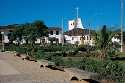
Der Distrikt Chachapoyas ist einer von 21 Distrikten der Provinz Chachapoyas in der Region Amazonas in Nord-Peru. Der Distrikt hat eine Fläche von 153 km². Beim Zensus 2017 lebten im Distrikt 32.589 Menschen. Im Jahr 1993 lag die Einwohnerzahl bei 17.447, im Jahr 2007 bei 23.939. Verwaltungssitz ist die Stadt Chachapoyas zugleich Provinz- und Regionshauptstadt.
Städte, Dörfer und Gehöfte im Distrikt Chachapoyas
- Achamaqui
- Bocanegra
- Caclic
- Chachapoyas
- El Alfalfar
- El Atajo
- El Cruce
- El Franco
- El Molino
- El Tapial
- Hidalgo
- Jupia
- Leticia
- Lucmauro
- Maripata
- Membrillo
- Mitopampa
- Opelel
- Osmal
- Penca Pampa
- Pollapampa
- Pucacruz
- Puente Utcubamba
- Rondon
- Sacra Huayco
- San Antonio
- San Isidro
- Santa Cruz
- Santa Isabel
- Silva Urco
- Taquia
- Taquipampa
- Villa Paris
- Vitaliano
Siehe auch
- Provinz Chachapoyas
- Region Amazonas
Weblinks
Commons: Distrikt Chachapoyas – Sammlung von Bildern, Videos und Audiodateien
- Peru: Region Amazonas (Provinzen und Bezirke) bei www.citypopulation.de


