Mozoncillo
| Gemeinde Mozoncillo | |||
|---|---|---|---|
| Wappen | Karte von Spanien | ||
 |
| ||
| Basisdaten | |||
| Land: | Spanien Spanien Spanien | ||
| Autonome Gemeinschaft: | Kastilienleon Kastilien und León Kastilien und León | ||
| Provinz: | Segovia | ||
| Comarca: | Cuéllar | ||
| Gerichtsbezirk: | Segovia | ||
| Koordinaten: | 41° 9′ N, 4° 11′ W41.147777777778-4.1861111111111857Koordinaten: 41° 9′ N, 4° 11′ W | ||
| Höhe: | 857 msnm | ||
| Fläche: | 42,74 km² | ||
| Einwohner: | 858 (1. Jan. 2022)[1] | ||
| Bevölkerungsdichte: | 20 Einw./km² | ||
| Postleitzahl(en): | 40250 | ||
| Gemeindenummer (INE): | 40134 Vorlage:Infobox Gemeinde in Spanien/Wartung/cod_ine | ||
| Verwaltung | |||
| Bürgermeister: | David de Santos Gómez | ||
| Website: | Mozoncillo | ||
| Lage des Ortes | |||
Karte anzeigen  | |||

Mozoncillo ist ein Ort und eine Gemeinde (municipio) mit 858 Einwohnern (Stand 1. Januar 2022) in der zentralspanischen Provinz Segovia in der Autonomen Region Kastilien-León.
Lage und Klima
Mozoncillo liegt in der kastilischen Meseta in ca. 855 m Höhe ungefähr 32 Kilometer (Fahrtstrecke) nordnordöstlich der Provinzhauptstadt Segovia. Das Klima ist gemäßigt bis warm; Regen (ca. 480 mm/Jahr) fällt mit Ausnahme der trockenen Sommermonate übers Jahr verteilt.[2]
Bevölkerungsentwicklung
| Jahr | 1970 | 1981 | 1991 | 2001 | 2011 | 2021 |
| Einwohner | 1188 | 1102 | 1074 | 1061 | 1032 | 851[3] |
Sehenswürdigkeiten
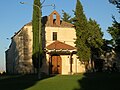
- Johannes-der-Täufer-Kirche
- Marienkapelle
- Christuskapelle
- Rochuskapelle
-
 Johannes-der-Täufer-Kirche
 -
 Marienkapelle
 -
 Rochuskapelle
 -
 Christuskapelle
 -
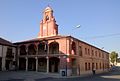 Rathaus


Weblinks
Commons: Mozoncillo – Sammlung von Bildern, Videos und Audiodateien
Einzelnachweise
- ↑ Cifras oficiales de población de los municipios españoles en aplicación de la Ley de Bases del Régimen Local (Art. 17). Instituto Nacional de Estadística; abgerufen am 19. Mai 2023 (Bevölkerungsstatistiken des Instituto Nacional de Estadística, Stand 1. Januar 2022).
- ↑ Mozoncillo – Klimatabellen
- ↑ Mozoncillo – Bevölkerungsentwicklung

Gemeinden in der Provinz Segovia
Abades | Adrada de Pirón | Adrados | Aguilafuente | Alconada de Maderuelo | Aldea Real | Aldealcorvo | Aldealengua de Pedraza | Aldealengua de Santa María | Aldeanueva de la Serrezuela | Aldeanueva del Codonal | Aldeasoña | Aldehorno | Aldehuela del Codonal | Aldeonte | Anaya | Añe | Arahuetes | Arcones | Arevalillo de Cega | Armuña | Ayllón | Barbolla | Basardilla | Bercial | Bercimuel | Bernardos | Bernuy de Porreros | Boceguillas | Brieva | Caballar | Cabañas de Polendos | Cabezuela | Calabazas de Fuentidueña | Campo de San Pedro | Cantalejo | Cantimpalos | Carabias | Carbonero el Mayor | Carrascal del Río | Casla | Castillejo de Mesleón | Castro de Fuentidueña | Castrojimeno | Castroserna de Abajo | Castroserracín | Cedillo de la Torre | Cerezo de Abajo | Cerezo de Arriba | Chañe | Cilleruelo de San Mamés | Cobos de Fuentidueña | Coca | Codorniz | Collado Hermoso | Condado de Castilnovo | Corral de Ayllón | Cozuelos de Fuentidueña | Cubillo | Cuéllar | Cuevas de Provanco | Domingo García | Donhierro | Duruelo | Encinas | Encinillas | Escalona del Prado | Escarabajosa de Cabezas | Escobar de Polendos | El Espinar | Espirdo | Fresneda de Cuéllar | Fresno de Cantespino | Fresno de la Fuente | Frumales | Fuente de Santa Cruz | Fuente el Olmo de Fuentidueña | Fuente el Olmo de Íscar | Fuentepelayo | Fuentepiñel | Fuenterrebollo | Fuentesaúco de Fuentidueña | Fuentesoto | Fuentidueña | Gallegos | Garcillán | Gomezserracín | Grajera | Honrubia de la Cuesta | Hontalbilla | Hontanares de Eresma | Los Huertos | Ituero y Lama | Juarros de Riomoros | Juarros de Voltoya | Labajos | Laguna de Contreras | Languilla | Lastras de Cuéllar | Lastras del Pozo | La Lastrilla | La Losa | Maderuelo | Marazoleja | Marazuela | Martín Miguel | Martín Muñoz de la Dehesa | Martín Muñoz de las Posadas | Marugán | Mata de Cuéllar | Matabuena | La Matilla | Melque de Cercos | Membibre de la Hoz | Migueláñez | Montejo de Arévalo | Montejo de la Vega de la Serrezuela | Monterrubio | Moral de Hornuez | Mozoncillo | Muñopedro | Muñoveros | Nava de la Asunción | Navafría | Navalilla | Navalmanzano | Navares de Ayuso | Navares de Enmedio | Navares de las Cuevas | Navas de Oro | Navas de Riofrío | Navas de San Antonio | Nieva | Olombrada | Orejana | Ortigosa de Pestaño | Ortigosa del Monte | Otero de Herreros | Pajarejos | Palazuelos de Eresma | Pedraza | Pelayos del Arroyo | Perosillo | Pinarejos | Pinarnegrillo | Prádena | Puebla de Pedraza | Rapariegos | Rebollo | Remondo | Riaguas de San Bartolomé | Riaza | Ribota | Riofrío de Riaza | Roda de Eresma | Sacramenia | Samboal | San Cristóbal de Cuéllar | San Cristóbal de la Vega | San Cristóbal de Segovia | Real Sitio de San Ildefonso | San Martín y Mudrián | San Miguel de Bernuy | San Pedro de Gaíllos | Sanchonuño | Sangarcía | Santa María la Real de Nieva | Santa Marta del Cerro | Santiuste de Pedraza | Santiuste de San Juan Bautista | Santo Domingo de Pirón | Santo Tomé del Puerto | Sauquillo de Cabezas | Sebúlcor | Segovia | Sepúlveda | Sequera de Fresno | Sotillo | Sotosalbos | Tabanera la Luenga | Tolocirio | Torre Val de San Pedro | Torreadrada | Torrecaballeros | Torrecilla del Pinar | Torreiglesias | Trescasas | Turégano | Urueñas | Valdeprados | Valdevacas de Montejo | Valdevacas y Guijar | Valle de Tabladillo | Vallelado | Valleruela de Pedraza | Valleruela de Sepúlveda | Valseca | Valtiendas | Valverde del Majano | Veganzones | Vegas de Matute | Ventosilla y Tejadilla | Villacastín | Villaverde de Íscar | Villaverde de Montejo | Villeguillo | Yanguas de Eresma | Zarzuela del Monte | Zarzuela del Pinar


