Arapaho Glacier
Glacier in Colorado, USA
40°01′24″N 105°38′52″W / 40.02333°N 105.64778°W / 40.02333; -105.64778[1]
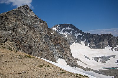
Arapaho Glacier is an alpine glacier in a cirque immediately southeast of North Arapaho Peak, in Roosevelt National Forest in the U.S. state of Colorado.[3] The glacier is just east of the Continental Divide. Arapaho Glacier is the largest glacier in the state of Colorado and helps provide water for the city of Boulder, Colorado. The glacier has a negative glacier mass balance and lost over 52% of its surface area during the 20th Century.[2]
See also
References
- ^ "Arapaho Glacier". Geographic Names Information System. United States Geological Survey, United States Department of the Interior. Retrieved August 18, 2012.
- ^ a b c d "Arapaho Glacier". National Snow and Ice Data Center. Retrieved October 2, 2017. (dead link 28 April 2018)
- ^ Monarch Lake, CO (Map). TopoQwest (United States Geological Survey Maps). Retrieved August 18, 2012.
Wikimedia Commons has media related to Arapaho Glacier.
External links
- Glaciers and Glacier Change in Rocky Mountain National Park
- v
- t
- e
Glaciers of Colorado
- Andrews Glacier
- Arapaho Glacier
- Arikaree Glacier
- Fair Glacier
- Isabelle Glacier
- Mills Glacier
- Moomaw Glacier
- Navajo Glacier
- Peck Glacier
- Rowe Glacier
- Saint Mary's Glacier
- Saint Vrain Glaciers
- Sprague Glacier
- Taylor Glacier
- The Dove
- Tyndall Glacier
Authority control databases | |
|---|---|
| International |
|
| National |
|
 | This Colorado state location article is a stub. You can help Wikipedia by expanding it. |
- v
- t
- e
 | This article about a glacier in the United States is a stub. You can help Wikipedia by expanding it. |
- v
- t
- e


