Ashville, Manitoba


class=notpageimage|
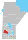
Location of Ashville in ManitobaAshville is an unincorporated community in the Rural Municipality of Gilbert Plains, Manitoba, Canada.
It is located along Highway 10 and the CPR tracks, 20 kilometers (12 mi) north-west of the City of Dauphin. It lies at an elevation of 340 meters (1,120 ft), south of the Valley River and north of the Riding Mountain National Park.
The community was named after Isaac Ash, a person of Irish descent who settled in the area.[1]
The Ashville Formation, a stratigraphical unit of the Western Canadian Sedimentary Basin, was named for this community.
See also
References
- ^ ePodunk. "Ashville Manitoba". Retrieved October 5, 2009.
- v
- t
- e
Division No. 17, Manitoba (Dauphin Area)
- Dauphin
| Former towns |
|
|---|
| Former villages |
|
|---|
| Former RMs |
|---|
- Ebb and Flow
- Keeseekoowenin (Partly)
- Alonsa
- Amaranth
- Ashville
- Bacon Ridge
- Bluff Creek
- Cayer
- East Bay
- Eddystone
- Fork River
- Freedale
- Garland
- Glencairn
- Halicz
- Harcus
- Keld
- Kinosota
- Laurier
- Lonely Lake
- Magnet
- Makinak
- Manitoba House
- Meharry
- Million
- Mink Creek
- Moore Dale
- Moose Bay
- Norgate
- North Junction
- Oak Brae
- Ochre River
- Paulson
- Portia
- Reedy Creek
- Reeve
- Reykjavik
- Rorketon
- Ste. Amélie
- Shergrove
- Sifton
- Silver Ridge
- Toutes Aides
- Trembowla
- Valley River
- Valpoy
- Venlaw
- Volga
- Weiden
- Zoria
51°10′30″N 100°17′45″W / 51.17500°N 100.29583°W / 51.17500; -100.29583
 | This Manitoba location article is a stub. You can help Wikipedia by expanding it. |
- v
- t
- e


