Clayton Peak
Mountain in Utah, United States


Clayton Peak
Location in Utah
Show map of Utah
Clayton Peak
Clayton Peak (the United States)
Show map of the United StatesRocky Mountains
Clayton Peak, also known unofficially as Mount Majestic, is a 10,721-foot-elevation (3,268-meter) summit on the boundary that Salt Lake County shares with Wasatch County, in Utah, United States.
Description
Clayton Peak is located 22 miles (35 km) southeast of downtown Salt Lake City and 1.5 miles (2.4 km) southeast of Brighton in the Wasatch–Cache National Forest.[4] The peak is set in the Wasatch Range which is a subrange of the Rocky Mountains. Precipitation runoff from the mountain's west slope drains into headwaters of Big Cottonwood Creek, whereas the east slope drains to Snake Creek. Topographic relief is significant as the summit rises 2,900 feet (884 meters) above Snake Creek in 1.5 mile (2.4 km). From Guardsman Pass, reaching the top involves 2.2 miles (round-trip) of hiking along a portion of the Great Western Trail with 1,015 feet of elevation gain.[6] The summit provides views of the Brighton Lakes area, the Uinta Mountains, Heber Valley, and Mount Timpanogos.[1] This mountain's toponym has been officially adopted by the United States Board on Geographic Names,[3] and has been recorded in publications since at least 1891.[7]
Climate
Clayton Peak has a subarctic climate (Köppen Dfc), bordering on an Alpine climate (Köppen ET), with long, cold, snowy winters, and cool to warm summers.[8] Due to its altitude, it receives precipitation all year, as snow in winter, and as thunderstorms in summer. This climate supports skiing at the Brighton Ski Resort on the peak's west slope.
Gallery
-
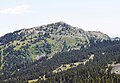 West aspect
 -
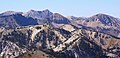 View from Clayton Peak looking toward Sugarloaf Mountain (center), Twin Peaks behind left, Mount Baldy to right.


References
- ^ a b Clayton Peak Trail #025, US Forest Service, Retrieved 2024-06-06.
- ^ a b c d e "Clayton Peak - 10,721' UT". listsofjohn.com. Retrieved 2024-06-06.
- ^ a b "Clayton Peak". Geographic Names Information System. United States Geological Survey, United States Department of the Interior. Retrieved 2024-06-06.
- ^ a b "Clayton Peak, Utah". Peakbagger.com. Retrieved 2024-06-06.
- ^ Laurence P. James, Geology, Ore Deposits, and History of the Big Cottonwood Mining District, Salt Lake County, Utah, Utah Geological Survey, 1979.
- ^ Greg Witt, 60 Hikes Within 60 Miles: Salt Lake City, Menasha Ridge Press, 2012, ISBN 9780897329439, p. 145.
- ^ Henry Gannett, United States Geological Survey (1891), A Dictionary of Altitudes in the United States, US Government Printing Office, p. 89.
- ^ Peel, M. C.; Finlayson, B. L.; McMahon, T. A. (2007). "Updated world map of the Köppen−Geiger climate classification". Hydrol. Earth Syst. Sci. 11. ISSN 1027-5606.
External links
- Clayton Peak Trail: US Forest Service
- Clayton Peak: weather forecast
- National Geodetic Survey Data Sheet
Places adjacent to Clayton Peak | ||||||||||||||||
|---|---|---|---|---|---|---|---|---|---|---|---|---|---|---|---|---|
| ||||||||||||||||


Portals:
 Geography
 Geology
 Mountains


