Comiskey, Kansas
Ghost town in Morris County, Kansas
Ghost town in Kansas, United States
38°38′40″N 96°21′15″W / 38.64444°N 96.35417°W / 38.64444; -96.35417[1][1]
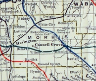
Comiskey is a ghost town in Morris County, Kansas, United States.[1] It was located approximately 6 miles (9.7 km) east of Council Grove, next to the county line.
History
Comiskey was platted in 1887 and originally a whistle-stop of the Missouri Pacific Railroad. A post office existed in Comiskey from 1887 to 1929 (about 42 years).[2] In 1910, the community had a population of 28.[3]
Following the St. Louis Browns victory in the 1886 World Series over the Chicago White Stockings, the Missouri Pacific Railroad honored several of the St. Louis players by naming some of their depots after the players. This community was named in honor of St. Louis Browns 1st baseman Charles Comiskey (later he founded Chicago White Sox and built Comiskey Park). The neighboring city of Bushong was named after Doc Bushong from the same team.[4]
Comiskey Cemetery still exists about 0.5 miles (0.80 km) north of the former community at southwest of the intersection of 100 Rd and U Ave.
-
 1887 deed for town of Comiskey
 -
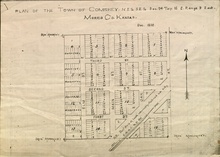 1887 platt for town of Comiskey
 -
 1915-1918 railroad map of Morris County (incorrectly showing Comiskey east of the county line)


Geography
Comiskey was located at 38°38′40″N 96°21′15″W / 38.64444°N 96.35417°W / 38.64444; -96.35417 (38.6444525, -96.3541663),[1] which is about 1.5 miles (2.4 km) south of U.S. 56 highway on 100 Rd in Morris County, Kansas. 100 Rd is the county line between Morris and Lyon counties.
References
- ^ a b c d e "Comiskey, Kansas", Geographic Names Information System, United States Geological Survey, United States Department of the Interior
- ^ Kansas Post Offices, 1828-1961; Kansas Historical Society.
- ^ Kansas : A Cyclopedia of State History, Embracing Events, Institutions, Industries, Counties, Cities, Towns, Prominent Persons, Etc; Frank W. Blackmar; Standard Publishing Co; 2723 pages (in 3 volumes); 1912.
- ^ "Why are a handful of Kansas ghost towns named after former Major Leaguers?". Major League Baseball. February 12, 2016. Archived from the original on October 21, 2018.
Further reading
- Living in the Depot: The Two-Story Railroad Station; H. Roger Grant; University of Iowa Press; 130 pages; 1993; ISBN 978-0877455882. Contains historic images of Kansas stations at Alta Vista, Bucklin, Comiskey, Haddam, Hoyt, and Wakarusa.
External links
Wikimedia Commons has media related to Comiskey, Kansas.
- Morris County maps: Current, Historic, KDOT
- v
- t
- e
Municipalities and communities of Morris County, Kansas, United States
County seat: Council Grove

communities
- Comiskey‡
- Cambria
- Overland
- Township 1
- Township 2
- Township 3
- Township 4
- Township 5
- Township 6
- Township 7
- Township 8
- Township 9
‡This community also has portions in an adjacent county or counties.
- Kansas portal
- United States portal


