Denison County
Map all coordinates using OpenStreetMap
Download coordinates as:
- KML
- GPX (all coordinates)
- GPX (primary coordinates)
- GPX (secondary coordinates)
Cadastral in New South Wales, Australia
| Denison New South Wales | |||||||||||||||
|---|---|---|---|---|---|---|---|---|---|---|---|---|---|---|---|
 Location in New South Wales | |||||||||||||||
| |||||||||||||||
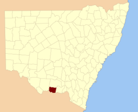
Denison County is one of the 141 cadastral divisions of New South Wales. It contains the towns of Barooga and Berrigan.
Denison County was named in honour of the Governor-General of New South Wales, Sir William Thomas Denison (1804-1871).[1]
Parishes within this county

A full list of parishes found within this county; their current LGA and mapping coordinates to the approximate centre of each location is as follows:
| Parish | LGA | Coordinates |
|---|---|---|
| Barooga | Berrigan Shire Council | 35°49′54″S 145°40′04″E / 35.83167°S 145.66778°E / -35.83167; 145.66778 (Barooga) |
| Berrigan | Berrigan Shire Council | 35°33′54″S 145°44′04″E / 35.56500°S 145.73444°E / -35.56500; 145.73444 (Berrigan) |
| Boomanoomana | Berrigan Shire Council | 35°54′54″S 145°54′04″E / 35.91500°S 145.90111°E / -35.91500; 145.90111 (Boomanoomana) |
| Bull Plain | Federation Council | 35°44′54″S 146°10′04″E / 35.74833°S 146.16778°E / -35.74833; 146.16778 (Bull Plain) |
| Carlyle | Berrigan Shire Council | 35°49′54″S 145°54′04″E / 35.83167°S 145.90111°E / -35.83167; 145.90111 (Carlyle) |
| Coreen West | Federation Council | 35°38′54″S 146°14′04″E / 35.64833°S 146.23444°E / -35.64833; 146.23444 (Coreen West) |
| Cottadidda | Berrigan Shire Council | 35°54′54″S 145°45′04″E / 35.91500°S 145.75111°E / -35.91500; 145.75111 (Cottadidda) |
| Denison | Federation Council | 35°47′54″S 146°09′04″E / 35.79833°S 146.15111°E / -35.79833; 146.15111 (Denison) |
| Dry Forest | Federation Council | 30°52′54″S 146°10′04″E / 30.88167°S 146.16778°E / -30.88167; 146.16778 (Dry Forest) |
| Finley | Berrigan Shire Council | 35°38′54″S 145°36′04″E / 35.64833°S 145.60111°E / -35.64833; 145.60111 (Finley) |
| Gereldery | Berrigan Shire Council | 35°41′54″S 145°49′04″E / 35.69833°S 145.81778°E / -35.69833; 145.81778 (Gereldery) |
| Headford | Berrigan Shire Council | 35°44′54″S 145°42′04″E / 35.74833°S 145.70111°E / -35.74833; 145.70111 (Headford) |
| Kilnyana | Berrigan Shire Council | 35°45′54″S 145°55′04″E / 35.76500°S 145.91778°E / -35.76500; 145.91778 (Kilnyana) |
| Lalalty | Berrigan Shire Council | 35°50′54″S 145°46′04″E / 35.84833°S 145.76778°E / -35.84833; 145.76778 (Lalalty) |
| Langunya | Berrigan Shire Council | 35°43′54″S 145°36′04″E / 35.73167°S 145.60111°E / -35.73167; 145.60111 (Langunya) |
| Momolong | Federation Council | 35°35′54″S 146°00′04″E / 35.59833°S 146.00111°E / -35.59833; 146.00111 (Momolong) |
| Mulwala | Federation Council | 35°55′54″S 146°01′04″E / 35.93167°S 146.01778°E / -35.93167; 146.01778 (Mulwala) |
| Nangunia | Berrigan Shire Council | 35°45′54″S 145°48′04″E / 35.76500°S 145.80111°E / -35.76500; 145.80111 (Nangunia) |
| Narrow Plains | Federation Council | 35°37′54″S 146°04′04″E / 35.63167°S 146.06778°E / -35.63167; 146.06778 (Narrow Plains) |
| Osborne | Berrigan Shire Council | 35°36′54″S 145°50′04″E / 35.61500°S 145.83444°E / -35.61500; 145.83444 (Osborne) |
| Sargood | Berrigan Shire Council | 35°32′54″S 145°38′04″E / 35.54833°S 145.63444°E / -35.54833; 145.63444 (Sargood) |
| Savernake | Federation Council | 35°45′54″S 146°01′04″E / 35.76500°S 146.01778°E / -35.76500; 146.01778 (Savernake) |
| Tocumwal | Berrigan Shire Council | 35°46′54″S 145°33′04″E / 35.78167°S 145.55111°E / -35.78167; 145.55111 (Tocumwal) |
| Tongaboo | Berrigan Shire Council | 35°32′54″S 145°34′04″E / 35.54833°S 145.56778°E / -35.54833; 145.56778 (Tongaboo) |
| Turramia | Federation Council | 35°56′54″S 146°07′04″E / 35.94833°S 146.11778°E / -35.94833; 146.11778 (Turramia) |
| Ulupna | Berrigan Shire Council | 35°37′54″S 145°33′04″E / 35.63167°S 145.55111°E / -35.63167; 145.55111 (Ulupna) |
| Wahgunyah | Federation Council | 35°50′54″S 146°02′04″E / 35.84833°S 146.03444°E / -35.84833; 146.03444 (Wahgunyah) |
| Wangamong | Federation Council | 35°37′54″S 146°08′04″E / 35.63167°S 146.13444°E / -35.63167; 146.13444 (Wangamong) |
| Warmatta | Berrigan Shire Council | 35°41′54″S 145°55′04″E / 35.69833°S 145.91778°E / -35.69833; 145.91778 (Warmatta) |
| Warragubogra | Berrigan Shire Council | 35°38′54″S 145°42′04″E / 35.64833°S 145.70111°E / -35.64833; 145.70111 (Warragubogra) |
| Woperana | Berrigan Shire Council | 35°41′54″S 145°30′04″E / 35.69833°S 145.50111°E / -35.69833; 145.50111 (Woperana) |
References
- ^ "Denison". Geographical Names Register (GNR) of NSW. Geographical Names Board of New South Wales. Retrieved 4 August 2013.

- ^ The New atlas of Australia (John Sands 1886) map 21.


