Downtown Richford Historic District
Historic district in Vermont, United States
United States historic place
Downtown Richford Historic District | |
 | |
44°59′47″N 72°40′19″W / 44.99639°N 72.67194°W / 44.99639; -72.67194 | |
| Area | 12 acres (4.9 ha) |
|---|---|
| Architectural style | Italianate, Queen Anne |
| NRHP reference No. | 80000333[1] |
| Added to NRHP | August 22, 1980 |
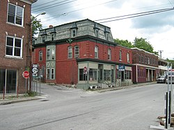
The Downtown Richford Historic District encompasses a cluster of commercial and industrial buildings at the center of Richford, Vermont. Centered on the junction of Main and River Streets are a cluster of mainly brick buildings, built between 1880 and 1920, with several industrial properties just across the Missisquoi River to the south, whose waters provided the power for the industries that fueled the town's growth. The district was listed on the National Register of Historic Places in 1980.[1]
Description and history
The northern Vermont town of Richford developed in the late 1790s around a series of falls on the upper Missisquoi River, where its early settlers built sawmills and gristmills. In the 1850s it developed as a regional commercial and industrial center, spurred by tariff reductions for trade with neighboring Quebec, which brought a market for area goods and an influx of French-speaking immigrants. The mills were located primarily on the south side of the falls, powered by a water diverted into a raceway east of the area, and the town's commercial center grew on the north side of the falls. The area declined economically after World War I, and has remained at a reduced level of economic activity since.[2]
The historic district encompasses both commercial and industrial buildings arranged on either side of the Missisquoi River, which Main Street crosses on a 1928 pony truss bridge, built after the previous crossing was washed away in 1927. From the junction of Main and River Streets, brick commercial buildings extend east and west on the south side of River Street, and on the north side west of the junction. These were almost all built between 1880 and 1920, and are in typical commercial variants of Italianate and Queen Anne styling. South of the river, on the west side of Main Street, stand two industrial buildings, built in 1908 out of concrete blocks by the Sweat-Comings Company, and the adjacent fire station, built by town but also out of concrete blocks.[2]
See also
References
- ^ a b "National Register Information System". National Register of Historic Places. National Park Service. July 9, 2010.
- ^ a b John Page (1980). "NRHP nomination for Downtown Richford Historic District". National Park Service. Retrieved October 22, 2016. with photos from 1980
- v
- t
- e
National Register of Historic Places in Franklin County, Vermont
- Ballard Farm
- Central Vermont Railroad Headquarters
- Downtown Richford Historic District
- St. Albans Historic District
- Billado Block
- Sheldon Boright House
- Brigham Academy
- Community Baptist Church and Parsonage
- District No. 2 School
- District No. 8 School
- Enosburg Congregational Memorial Church
- Enosburg Opera House
- Evarts-McWilliams House
- Fairfield Street School
- First Congregational Church of Swanton
- Fletcher Union Church
- Georgia Plain Baptist Church
- Giroux Furniture Company Building
- Solomon Goodrich Homestead
- Hathaway's Tavern
- Houghton House
- Kemp-Shepard House
- Dr. B. J. Kendall Company
- L'Ecole Saintes-Anges
- Methodist Episcopal Church
- Montgomery House
- Ovitt Grist Mill
- Parish of the Holy Trinity
- Perley Block
- Moses P. Perley House
- Quincy Hotel
- Richford Primary School
- Richwood Estate
- Rockledge
- St. Albans Town Hall
- St. Ann's Episcopal Church
- St. Bartholomew's Episcopal Church
- St. George's Catholic Church
- St. John's Episcopal Church
- Swanton School
- Sweat-Comings Company House
- U.S. Inspection Station-East Richford, Vermont
- U.S. Inspection Station-Richford, Vermont
- U.S. Inspection Station-West Berkshire, Vermont
- United States Post Office and Custom House
- Warner Home
- West Berkshire School
- F.W. Wheeler House
- Willard Manufacturing Company Building
- Bridge 9
- Bridge 12
- Bridge Number VT105-10
- Comstock Covered Bridge
- Douglas & Jarvis Patent Parabolic Truss Iron Bridge
- East Fairfield Covered Bridge
- Fairfax Covered Bridge
- Fuller Covered Bridge
- Hectorville Covered Bridge
- Hopkins Covered Bridge
- Hutchins Covered Bridge
- Longley Covered Bridge
- Missisquoi River Bridge
- Swanton Covered Railroad Bridge
- West Hill Covered Bridge


