Dupljaja
Дупљаја | |
|---|---|
 The Orthodox church | |
 Dupljaja Location of Dupljaja within Serbia  Dupljaja Dupljaja (Serbia)  Dupljaja Dupljaja (Europe) | |
| Coordinates: 44°55′22″N 21°16′23″E / 44.92278°N 21.27306°E | |
| Country | |
| Province | |
| District | South Banat |
| Municipality | |
| Elevation | 76 m (249 ft) |
| Population (2002) | |
• Dupljaja | 996 |
| Time zone | UTC+1 (CET) |
| • Summer (DST) | UTC+2 (CEST) |
| Postal code | 26328 |
| Area code | +381(0)13 |
| Car plates | VŠ |
You can help expand this article with text translated from the corresponding article in Serbian. (November 2022) Click [show] for important translation instructions.
|
Dupljaja (Serbian Cyrillic: Дупљаја) is a village in Serbia. It is situated in the Bela Crkva municipality, in the South Banat District, Vojvodina province on the bank of the river Karaš. The village has a Serb ethnic majority (90.74%) and a population of 996 (2002 census).
History and archaeology
[edit]Archaeologist have discovered the remains of the old Slavic city Karaš, which was the capital and the largest fort of Banat in the 11th century. The remains include part of an old church and part of the building which supposedly was the palace of the prince, as well as several hundred coins that originated from central and western Europe and pieces of golden and silver jewels. [1][permanent dead link]
There are also remains from Prehistory and from the Bronze Age (mostly belonging to the Dubovac culture). The most famous archaeological Bronze Age artifacts from Dupljaja are the so-called "Dupljaja chariots", which are about 3,500-3,300 years old,[1][2][3] and whose photograph features on Serbian drivers licenses.[4][5]
In 1921, the population of Dupljaja included 1,149 Serbs, 19 Romanians, 10 Slovaks, 10 Germans, and 2 Hungarians.
-
![Chariot model 1[6]](//upload.wikimedia.org/wikipedia/commons/thumb/7/7f/Dupljaja.jpg/120px-Dupljaja.jpg) Chariot model 1[6]
Chariot model 1[6] -
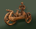 Chariot model 1, side view
 -
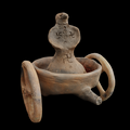 Chariot model 2
 -
 Chariot model 2, reverse view
![Chariot model 1[6]](https://wiki.gen.edu.vn/en/File:Dupljaja.jpg)
.jpg)


Historical population
[edit]- 1961: 1,174
- 1971: 1,165
- 1981: 1,152
- 1991: 1,027
- 2002: 854
- 2011: 738
See also
[edit]References
[edit]- ^ Harding, A. F. (2000-05-18). European Societies in the Bronze Age. Cambridge University Press. doi:10.1017/cbo9780511605901. ISBN 978-0-521-36729-5.
- ^ Molloy, Barry; et al. (2023). "Early Chariots and Religion in South-East Europe and the Aegean During the Bronze Age: A Reappraisal of the Dupljaja Chariot in Context". European Journal of Archaeology: 1–21. doi:10.1017/eaa.2023.39.
- ^ Bilić, Tomislav (2016-12-30). "The swan chariot of a solar deity: Greek narratives and prehistoric iconography". Documenta Praehistorica. 43. University of Ljubljana: 445–466. doi:10.4312/dp.43.23. ISSN 1854-2492.
- ^ RTS prilog
- ^ POGLEDAJTE SVOJU VOZAČKU DOZVOLU: Ovu sliku sigurno niste primetili, a reč je o najvažnijem artefaktu Srbije
- ^ Bilic, Tomislav (2016). "The swan chariot of a solar deity: Greek narratives and prehistoric iconography". Documenta Praehistorica. 43.
{{cite journal}}: CS1 maint: numeric names: authors list (link)
- RTS prilog
- Jovan Erdeljanović, Srbi u Banatu, Novi Sad, 1992.
- Slobodan Ćurčić, Broj stanovnika Vojvodine, Novi Sad, 1996.
External links
[edit]This South Banat District, Vojvodina location article is a stub. You can help Wikipedia by expanding it. |