El Pinacate y Gran Desierto de Altar Biosphere Reserve
UNESCO biosphere reserve in Sonora, Mexico
32°00′N 113°55′W / 32.000°N 113.917°W / 32.000; -113.917[1] UNESCO World Heritage Site
Ramsar Wetland
Pinacate volcanics with teddy-bear chollas, ocotillos, young saguaros, and a palo verde tree. Photo by Jack Dykinga.

Crater Elegante
El Pinacate and Gran Desierto de Altar Biosphere Reserve (Spanish: Reserva de la Biosfera El Pinacate y Gran Desierto de Altar) is a biosphere reserve and UNESCO World Heritage Site[1] managed by the federal government of Mexico, specifically by Secretariat of the Environment and Natural Resources, in collaboration with the state governments of Sonora and the Tohono O'odham.
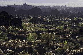
It is in the Sonoran Desert in northwest Mexico, east of the Gulf of California, in the eastern part of the Gran Desierto de Altar, just south of the border with Arizona, United States and north of the city of Puerto Peñasco. It is one of the most significant visible landforms in North America seen from space. A volcanic system known as Santa Clara is the main part of the landscape, including three peaks: Pinacate, Carnegie and Medio. It is a sister park to Organ Pipe Cactus National Monument in Arizona.[4] Its wildlife is threatened by the militarization of the Mexico–United States border and the construction of the Mexico–United States border wall.[5]
In the area there are over 540 species of plants, 40 species of mammals, 200 of birds, 40 of reptiles, amphibians and freshwater fishes.[6] There are threatened endemic species as Sonoran pronghorn, bighorn sheep, gila monster and desert tortoise.[7]
The biosphere reserve covers an area of 2,695.05 square kilometres (1,040.56 sq mi),[2] making up about half of the World Heritage site. The extent of the World Heritage site is 7,146 km²,[8][9] greater than that of the states of Aguascalientes, Colima, Morelos and Tlaxcala separated.[10]
Formation
El Pinacate y Gran Desierto de Altar Biosphere Reserve is known for its unique physical and biological characteristics, by the presence of a volcanic shield, and by the extensive areas of active dunes that surround it, and the greatest concentration of Maar craters. The Pinacate Mountains range has orogenic features of high interest, products of volcanic eruptions that accumulated lava in compact rocks, sand and volcanic ashes that formed colors of special beauty, and craters such as El Elegante, Cerro Colorado, MacDougal, and Sykes.[11]
The Pinacate Peaks (Picos del Pinacate), a group of volcanic peaks and cinder cones, are located in the Reserve north of Puerto Peñasco. The highest peak is Cerro del Pinacate (Santa Clara volcano), with an elevation of 1,190 metres (3,904 ft). Pinacate comes from Náhuatl language word pinacatl, for the Pinacate beetle, a stink beetle endemic to the Sonoran Desert.
The Pinacate Peaks volcanoes have erupted sporadically for about 4 million years. The most recent activity was about 11 000 years ago.
NASA sent astronauts to the Gran Desierto de Altar from 1965 to 1970, to train for walking on the Moon, due to the similarities of the terrain to the lunar surface.
History

Pre-Columbian era
The first inhabitants are known as San Dieguito people, they were hunter-gatherer who lived off the land, moving from the mountains to the Gulf of California looking for food. The early stages of occupation seem to have ended at the beginning of the ice age about 20000 years ago, when drought forced people to leave the mountain range.[12]
A second stage of occupation by San Dieguito people began in the late glacial period. This group returned to the mountains and lived as their ancestors had. Tinajas must have been a reliable source of water during this time. The second stage of occupation ended with the arrival of an antipyretic period 9000 years ago, which again forced the people to leave the territory.[6]
The most recent indigenous inhabitants of the Pinacate and Gran Desierto de Altar are the Pinacateño band of the Hia C-ed O'odham. Like the prehistoric San Dieguito culture, the Pinacateños roamed the Pinacate all the way to the sea in search of food, concentrating their camps near the tinajas. During these voyages, they left signs of their presence; one example of this is the network of paths that go from tinaja to tinaja, as well as the stone tools and potsherds found near these water sources.[6][13]
Explorations
There are few records of those who were the first explorers in this area. Possibly the first European to see the mountain now known as Sierra Pinacate was the explorer Melchior Díaz on 1540. Subsequently, in 1698 the priest Eusebio Kino, founder of Mission San Xavier del Bac in southern Tucson, Arizona, visited the site and returned on several occasions, he and his group climbed to the top of El Pinacate, which was then named Santa Clara Hill.[6]
Before 1956, few scientists and explorers had been in El Pinacate y Gran Desierto de Altar, the most famous, the group MacDougal, Hornaday and Sykes who explored the western part of the mountain in 1907.
References
- ^ a b UNESCO. "El Pinacate and Gran Desierto de Altar Biosphere Reserve". Retrieved June 24, 2013.
- ^ a b "El Pinacate y Gran Desierto de Altar Biosphere Reserve". Retrieved 15 June 2018.
- ^ "Agua Dulce". Ramsar Sites Information Service. Retrieved 25 April 2018.
- ^ "El Pinacate y Gran Desierto de Altar - Organ Pipe Cactus National Monument". U.S. National Park Service. Retrieved 2023-12-03.
- ^ "What a Border Wall Could Mean for Wildlife | Audubon". www.audubon.org. Retrieved 2023-12-03.
- ^ a b c d Comisión Nacional de Áreas Naturales Protegidas. "Reserva de la Biosfera El Pinacate y Gran Desierto de Altar". Archived from the original on August 12, 2016. Retrieved September 29, 2010.
- ^ Red Escolar. "Reserva de la Biosfera El Pinacate y Gran Desierto de Altar". Archived from the original on November 21, 2010. Retrieved September 29, 2010.
- ^ Comisión Nacional para el Conocimiento y Uso de la Biodiversidad. "Regiones terrestres prioritarias de México" (PDF). Retrieved September 29, 2010.
- ^ "El Pinacate y Gran Desierto de Altar World Heritage Site". Retrieved 15 June 2018.
- ^ INEGI. "Información por entidad". Archived from the original on 2011-07-23.
- ^ Instituto Nacional de Ecología. "Reserva de la Biosfera El Pinacate y Gran Desierto de Altar". Archived from the original on July 22, 2011. Retrieved September 29, 2010.
- ^ Hayden, 1998.
- ^ "Pinacate y Gran Desierto de Altar". Red Escolar. Archived from the original on November 21, 2010. Retrieved September 29, 2010.
- Jack Ruby’s Kitchen Sink: Offbeat Travels through America’s Southwest, by Tom Miller; pp. 10–26,
External links
Wikimedia Commons has media related to
El Pinacate y Gran Desierto de Altar.
El Pinacate y Gran Desierto de Altar.
- Official website
- Volcano.si.edu: Global Volcanism Program—Pinacate
- NASA: Satellite photo of Volcán Pinacate
- Azcentral.com: "Sierra Pinacate a Volcanic Wonder"
- v
- t
- e
- Archaeological Zone of Paquimé, Casas Grandes
- El Pinacate y Gran Desierto de Altar Biosphere Reserve
- Islands and Protected Areas of the Gulf of California1
- Rock Paintings of Sierra de San Francisco
- Whale Sanctuary of El Vizcaino
- Camino Real de Tierra Adentro
- Franciscan Missions in the Sierra Gorda of Querétaro
- Historic Centre of Zacatecas
- Historic Monuments Zone of Querétaro
- Historic Town of Guanajuato and Adjacent Mines
- Protected town of San Miguel de Allende and the Sanctuary of Jesús Nazareno de Atotonilco
- Agave Landscape and Ancient Industrial Facilities of Tequila
- Revillagigedo Archipelago
- Historic Centre of Morelia
- Hospicio Cabañas, Guadalajara
- Islands and Protected Areas of the Gulf of California1
- Monarch Butterfly Biosphere Reserve1
- Earliest 16th-century monasteries on the slopes of Popocatépetl1
- Pre-Hispanic City of El Tajín
- Historic Centre of Puebla
- Historic Monuments Zone of Tlacotalpan
- Historic Centre of Oaxaca and Archaeological Site of Monte Albán
- Prehistoric Caves of Yagul and Mitla in the Central Valley of Oaxaca
- Pre-Hispanic City and National Park of Palenque
- Archaeological Monuments Zone of Xochicalco
- Aqueduct of Padre Tembleque Hydraulic System
- Central University City Campus of the UNAM
- Earliest 16th-century monasteries on the slopes of Popocatépetl1
- Camino Real de Tierra Adentro
- Historic Centre of Mexico City and Xochimilco
- Luis Barragán House and Studio
- Monarch Butterfly Biosphere Reserve1
- Tehuacán-Cuicatlán Valley
- Pre-Hispanic City of Teotihuacán
- Ancient Maya City and Protected Tropical Forests of Calakmul,
- Historic Fortified Town of Campeche
- Pre-Hispanic City of Chichén Itzá
- Sian Kaʼan Biosphere Reserve
- Pre-Hispanic Town of Uxmal
- 1 Shared by more one region
Authority control databases | |
|---|---|
| International |
|
| National |
|


