Ferriday Commercial Historic District
Historic district in Louisiana, United States
United States historic place
Ferriday Commercial Historic District | |
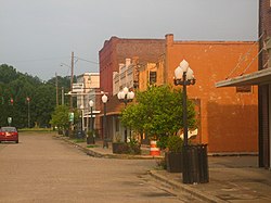 Historic buildings on 100 block Louisiana Avenue. | |
31°37′46″N 91°33′10″W / 31.62933°N 91.55269°W / 31.62933; -91.55269 | |
| Area | 4 acres (1.6 ha) |
|---|---|
| Architectural style | Italianate |
| NRHP reference No. | 94001584[1] |
| Added to NRHP | January 27, 1995 |
The 'Ferriday Commercial Historic District in Ferriday, Louisiana is the historic portion of what was the only surviving commercial center in large but rural Concordia Parish. It was listed as a historic district on the National Register of Historic Places in 1995.[1] The district included 21 buildings, all older than 50 years, as contributing buildings.[2][3]
The buildings are one- and two-story masonry commercial buildings, within a two block area, and were built between c.1905 and c.1940.[2][3]
One contributing building is the U.S. Post Office (1939), a one-story brick French Classical Revival building. It has false chimneys and arched windows. Its interior has Works Project Administration murals.[2][3]
Three of the contributing buildings, the one at 909 South 2nd Street and two adjoining commercial buildings along South 1st Street, are no more existing and disappeared at some time after the district was created .
Contributing properties
The historical district contains a total of 21 contributing properties, built c.1905 to c.1940:[2][3]
- U.S. Post Office, now Louisiana Delta Music Museum, 218 Louisiana Avenue, 31°37′47″N 91°33′13″W / 31.62966°N 91.55358°W / 31.62966; -91.55358 (Ferriday Post Office), built 1939.
- Building at 210 Louisiana Avenue, 31°37′47″N 91°33′11″W / 31.62965°N 91.55304°W / 31.62965; -91.55304 (210 Louisiana Avenue), built 1923–1926.
- Building at 208 Louisiana Avenue, 31°37′47″N 91°33′11″W / 31.62965°N 91.55295°W / 31.62965; -91.55295 (208 Louisiana Avenue), built 1923–1926.
- Building at 204 Louisiana Avenue, 31°37′47″N 91°33′10″W / 31.62965°N 91.55288°W / 31.62965; -91.55288 (204 Louisiana Avenue), built 1923–1926.
- Vogt's Ferriday Drug Store, 200 Louisiana Avenue, 31°37′47″N 91°33′10″W / 31.62965°N 91.5528°W / 31.62965; -91.5528 (Vogt's Ferriday Drug Store), built before 1923.
- Building at 906 South 2nd Street, 31°37′46″N 91°33′10″W / 31.62946°N 91.55281°W / 31.62946; -91.55281 (906 South 2nd Street), built 1926–1938.
- Wilson's Printing, 902 South 2nd Street, 31°37′45″N 91°33′10″W / 31.62915°N 91.55286°W / 31.62915; -91.55286 (Wilson's Printing), built 1926–1938.
- Building at 909 South 2nd Street, 31°37′46″N 91°33′09″W / 31.62937°N 91.55252°W / 31.62937; -91.55252 (909 South 2nd Street), built 1923–1926. No more existing.
- Building at 911 South 2nd Street, 31°37′46″N 91°33′09″W / 31.62947°N 91.55253°W / 31.62947; -91.55253 (911 South 2nd Street), built 1926–1938.
- Building at 913 South 2nd Street, 31°37′46″N 91°33′09″W / 31.62954°N 91.55253°W / 31.62954; -91.55253 (913 South 2nd Street), built 1923–1926.
- Building at 124-128 Louisiana Avenue, 31°37′47″N 91°33′09″W / 31.62964°N 91.55249°W / 31.62964; -91.55249 (124-128 Louisiana Avenue), built before 1923. Front quite altered from 1994 photo in NRHP form.
- Building at 120 Louisiana Avenue, 31°37′47″N 91°33′08″W / 31.62964°N 91.55233°W / 31.62964; -91.55233 (120 Louisiana Avenue), built before 1923.
- Concordia Drugs, 114-116 Louisiana Avenue, 31°37′47″N 91°33′08″W / 31.62964°N 91.55216°W / 31.62964; -91.55216 (Concordia Drugs), built before 1923.
- Building #1 at 110 Louisiana Avenue, 31°37′47″N 91°33′07″W / 31.62964°N 91.55194°W / 31.62964; -91.55194 (110 Louisiana Avenue #1), built 1923–1926.
- Building #2 at 110 Louisiana Avenue, 31°37′47″N 91°33′07″W / 31.62964°N 91.55183°W / 31.62964; -91.55183 (110 Louisiana Avenue #2), built 1926–1938.
- Ferriday Dental Clinic, 104 Louisiana Avenue, 31°37′47″N 91°33′06″W / 31.62964°N 91.5517°W / 31.62964; -91.5517 (Ferriday Dental Clinic), built before 1923.
- Commercial Building #1, 31°37′46″N 91°33′06″W / 31.62944°N 91.5517°W / 31.62944; -91.5517 (Commercial Building #1), built 1923–1926. No more existing.
- Commercial Building #2, 31°37′46″N 91°33′06″W / 31.62935°N 91.5517°W / 31.62935; -91.5517 (Commercial Building #2), built 1926–1938. No more existing.
- Commercial Building #3, 31°37′45″N 91°33′06″W / 31.6291°N 91.5517°W / 31.6291; -91.5517 (Commercial Building #3), built c.1940.
- Commercial Building #4, 31°37′44″N 91°33′06″W / 31.62897°N 91.5517°W / 31.62897; -91.5517 (Commercial Building #4), built 1923–1926.
- Myer Discount House, 31°37′43″N 91°33′06″W / 31.62857°N 91.5517°W / 31.62857; -91.5517 (Myer Discount House), built before 1923.
Map this section's coordinates using OpenStreetMap
Download coordinates as:
- KML
- GPX (all coordinates)
- GPX (primary coordinates)
- GPX (secondary coordinates)
See also
References
- ^ a b "National Register Information System". National Register of Historic Places. National Park Service. July 9, 2010.
- ^ a b c d "Ferriday Commercial Historic Distr" (PDF). State of Louisiana's Division of Historic Preservation. 1995. Retrieved July 31, 2017. with photos and maps
- ^ a b c d National Register Staff (November 1994). "National Register of Historic Places Registration Form: Ferriday Commercial Historic District". National Park Service. Retrieved April 29, 2018. With 18 photos from 1994.
Notes
External links
![]() Media related to Ferriday Commercial Historic District at Wikimedia Commons
Media related to Ferriday Commercial Historic District at Wikimedia Commons
- v
- t
- e
by parish
- Acadia
- Allen
- Ascension
- Assumption
- Avoyelles
- Beauregard
- Bienville
- Bossier
- Caddo
- Calcasieu
- Caldwell
- Cameron
- Catahoula
- Claiborne
- Concordia
- DeSoto
- East Baton Rouge
- East Carroll
- East Feliciana
- Evangeline
- Franklin
- Grant
- Iberia
- Iberville
- Jackson
- Jefferson
- Jefferson Davis
- La Salle
- Lafayette
- Lafourche
- Lincoln
- Livingston
- Madison
- Morehouse
- Natchitoches
- Orleans
- Ouachita
- Plaquemines
- Pointe Coupee
- Rapides
- Red River
- Richland
- Sabine
- St. Bernard
- St. Charles
- St. Helena
- St. James
- St. John the Baptist
- St. Landry
- St. Martin
- St. Mary
- St. Tammany
- Tangipahoa
- Tensas
- Terrebonne
- Union
- Vermilion
- Vernon
- Washington
- Webster
- West Baton Rouge
- West Carroll
- West Feliciana
- Winn

Portals:
 National Register of Historic Places
 United States
Municipalities and communities of Concordia Parish, Louisiana, United States | ||
|---|---|---|
Parish seat: Vidalia | ||
| Cities | 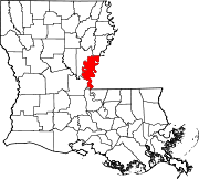 | |
| Towns | ||
| CDPs | ||
| Other communities |
| |
| ||
 | This article about a property in Louisiana on the National Register of Historic Places is a stub. You can help Wikipedia by expanding it. |
- v
- t
- e


