Grade II* listed buildings in North Dorset

Map all coordinates using OpenStreetMap
Download coordinates as:
- KML
- GPX (all coordinates)
- GPX (primary coordinates)
- GPX (secondary coordinates)
There are over 20,000 Grade II* listed buildings in England. This is a list of these buildings in the former district of North Dorset in the county of Dorset.
North Dorset
| Name | Location | Type | Completed [note 1] | Date designated | Grid ref.[note 2] Geo-coordinates | Entry number [note 3] | Image |
|---|---|---|---|---|---|---|---|
| Tomson Farmhouse | Winterborne Tomson, Anderson | Farmhouse | Early 17th century | 14 July 1955 | SY8856897403 50°46′34″N 2°09′49″W / 50.776092°N 2.163502°W / 50.776092; -2.163502 (Tomson Farmhouse) | 1324258 |  More images |
| Dale House | Blandford Forum | Detached house | c. 1690–1700 | 27 October 1950 | ST8856106639 50°51′33″N 2°09′50″W / 50.859146°N 2.163892°W / 50.859146; -2.163892 (Dale House) | 1153057 |  Upload Photo |
| Eastway House | Blandford Forum | House | Possibly after 1731 | 27 October 1950 | ST8879406373 50°51′24″N 2°09′38″W / 50.856759°N 2.160574°W / 50.856759; -2.160574 (Eastway House) | 1108704 |  More images |
| Lime Tree House | Blandford Forum | House | Early to mid-18th century | 27 October 1950 | ST8850806407 50°51′25″N 2°09′53″W / 50.857059°N 2.164638°W / 50.857059; -2.164638 (Lime Tree House) | 1108653 | 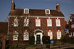 More images |
| Lyston House | Blandford Forum | House | Probably post-1731 to mid-18th century | 27 October 1950 | ST8868606350 50°51′24″N 2°09′44″W / 50.85655°N 2.162107°W / 50.85655; -2.162107 (Lyston House) | 1108679 | Upload Photo |
| Ryves Almshouses | Blandford Forum | Almshouse | 1682 | 27 October 1950 | ST8853006518 50°51′29″N 2°09′52″W / 50.858058°N 2.164329°W / 50.858058; -2.164329 (Ryves Almshouses) | 1108628 |  More images |
| 1 Market Place | Blandford Forum | House | Post-1731 | 27 October 1950 | ST8842906291 50°51′22″N 2°09′57″W / 50.856014°N 2.165757°W / 50.856014; -2.165757 (1 Market Place) | 1108683 | Upload Photo |
| 9 Market Place | Blandford Forum | House | Probably late 18th century | 27 October 1950 | ST8845506307 50°51′22″N 2°09′55″W / 50.856159°N 2.165388°W / 50.856159; -2.165388 (9 Market Place) | 1304602 | Upload Photo |
| Church of St Mary | Lower Blandford St Mary, Blandford St Mary | Anglican parish church | 14th century tower | 14 July 1955 | ST8916805271 50°50′49″N 2°09′19″W / 50.846857°N 2.155227°W / 50.846857; -2.155227 (Church of St Mary) | 1110176 |  More images |
| The Manor House | Lower Blandford St Mary, Blandford St. Mary | Manor house | Early 17th century | 14 July 1955 | ST8909205536 50°50′57″N 2°09′23″W / 50.849238°N 2.156315°W / 50.849238; -2.156315 (The Manor House) | 1171679 | 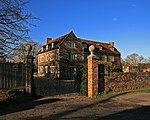 |
| Church of St John | Buckhorn Weston | Anglican parish church | 14th-century origin | 3 January 1985 | ST7569024717 51°01′17″N 2°20′53″W / 51.021306°N 2.34797°W / 51.021306; -2.34797 (Church of St John) | 1324559 | 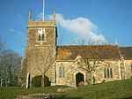 More images |
| Church of St Mary | Chettle | Anglican parish church | Early 16th-century tower | 14 July 1955 | ST9515813283 50°55′08″N 2°04′13″W / 50.918986°N 2.070254°W / 50.918986; -2.070254 (Church of St Mary) | 1324295 |  More images |
| Church of St Nicholas | Child Okeford | Anglican parish church | Late 15th or early 16th-century tower | 4 October 1960 | ST8355312750 50°54′50″N 2°14′07″W / 50.913977°N 2.235321°W / 50.913977; -2.235321 (Church of St Nicholas) | 1110263 |  More images |
| Fontmell Parva House | Fontmell Parva, Child Okeford | House | c. 1665 | 12 October 1978 | ST8269014550 50°55′48″N 2°14′52″W / 50.930137°N 2.247683°W / 50.930137; -2.247683 (Fontmell Parva House) | 1324593 | 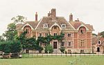 More images |
| Church of St Nicholas | Durweston | Anglican parish church | 15th-century tower | 14 July 1955 | ST8587308523 50°52′34″N 2°12′08″W / 50.876028°N 2.202156°W / 50.876028; -2.202156 (Church of St Nicholas) | 1110271 | 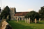 More images |
| Durweston Bridge | Durweston | Road bridge | 1795 | 14 July 1955 | ST8635808628 50°52′37″N 2°11′43″W / 50.876984°N 2.195267°W / 50.876984; -2.195267 (Durweston Bridge) | 1110240 |  More images |
| Church of St Lawrence | Farnham | Anglican parish church | Probably 12th-century origin | 14 July 1955 | ST9578315050 50°56′06″N 2°03′41″W / 50.934881°N 2.061383°W / 50.934881; -2.061383 (Church of St Lawrence) | 1172411 | 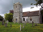 More images |
| Church of All Saints | Fifehead Neville | Anglican parish church | c. 1500 | 4 October 1960 | ST7679911001 50°53′53″N 2°19′53″W / 50.898016°N 2.33128°W / 50.898016; -2.33128 (Church of All Saints) | 1324503 |  More images |
| Footbridge over the River Divelish | Fifehead Neville | Packhorse bridge | Medieval | 4 October 1960 | ST7718911146 50°53′58″N 2°19′33″W / 50.899328°N 2.325755°W / 50.899328; -2.325755 (Footbridge over the River Divelish) | 1110485 |  More images |
| Church of St Andrew | Fontmell Magna | Anglican parish church | 15th-century origin | 16 August 1960 | ST8654016985 50°57′08″N 2°11′35″W / 50.952137°N 2.192991°W / 50.952137; -2.192991 (Church of St Andrew) | 1305380 |  More images |
| Parish Church of St Mary | Glanvilles Wootton | Anglican parish church | South chapel c. 1344 | 4 October 1960 | ST6802508155 50°52′19″N 2°27′21″W / 50.872003°N 2.45579°W / 50.872003; -2.45579 (Parish Church of St Mary) | 1110491 | 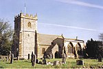 More images |
| Round Chimneys Farmhouse | Glanvilles Wootton | House | c. 1590s | 4 October 1960 | ST6819009457 50°53′01″N 2°27′13″W / 50.88372°N 2.453559°W / 50.88372; -2.453559 (Round Chimneys Farmhouse) | 1324467 |  More images |
| Manor House | Hammoon | Manor house | 16th century | 4 October 1960 | ST8173614612 50°55′50″N 2°15′41″W / 50.930665°N 2.261261°W / 50.930665; -2.261261 (Manor House) | 1110215 | 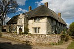 More images |
| Church of St Michael and All Angels | Hanford | Anglican parish church | 17th century | 4 October 1960 | ST8456411178 50°54′00″N 2°13′15″W / 50.899869°N 2.220874°W / 50.899869; -2.220874 (Church of St Michael and All Angels) | 1110147 | 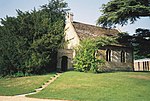 More images |
| Hanford School | Hanford | Country house | 1623 | 14 October 1960 | ST8448011111 50°53′57″N 2°13′19″W / 50.899264°N 2.222065°W / 50.899264; -2.222065 (Hanford School) | 1110146 |  More images |
| Church of St Peter | Hinton St Mary | Anglican parish church | 15th-century tower | 4 October 1960 | ST7867816099 50°56′38″N 2°18′18″W / 50.943931°N 2.304862°W / 50.943931; -2.304862 (Church of St Peter) | 1110423 |  More images |
| Dalton's Farmhouse Including Front Garden Walls | Hinton St Mary | House | Early to mid-18th century | 4 October 1960 | ST7868716280 50°56′44″N 2°18′17″W / 50.945559°N 2.304744°W / 50.945559; -2.304744 (Dalton's Farmhouse Including Front Garden Walls) | 1110428 |  More images |
| Stable block 40m south of St Peter's Church | Hinton St Mary | Stable | Probably 16th century | 4 October 1960 | ST7869216049 50°56′37″N 2°18′17″W / 50.943482°N 2.30466°W / 50.943482; -2.30466 (Stable block 40m south of St Peter's Church) | 1324511 | Upload Photo |
| The Manor House | Hinton St Mary | Manor house | Possibly 13th century | 4 October 1960 | ST7870316121 50°56′39″N 2°18′16″W / 50.94413°N 2.304507°W / 50.94413; -2.304507 (The Manor House) | 1110420 | 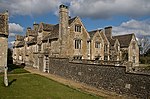 More images |
| Tithe Barn Approximately 100 Metres South of Hinton St Mary Manor House | Hinton St Mary | Tithe barn | Probably 15th century | 4 October 1960 | ST7872816032 50°56′36″N 2°18′15″W / 50.943331°N 2.304146°W / 50.943331; -2.304146 (Tithe Barn Approximately 100 Metres South of Hinton St Mary Manor House) | 1110422 | Upload Photo |
| Parish Church of St Eustace | Ibberton | Anglican parish church | 15th century | 4 October 1960 | ST7893407562 50°52′02″N 2°18′03″W / 50.867174°N 2.300723°W / 50.867174; -2.300723 (Parish Church of St Eustace) | 1287985 | 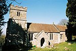 More images |
| The Chantry | Iwerne Minster | House | 17th century | 16 August 1960 | ST8679514414 50°55′44″N 2°11′21″W / 50.929024°N 2.189267°W / 50.929024; -2.189267 (The Chantry) | 1172228 |  |
| Church of St Mary | Iwerne Stepleton | Anglican parish church | 11th century | 14 July 1955 | ST8628211246 50°54′02″N 2°11′47″W / 50.900524°N 2.196446°W / 50.900524; -2.196446 (Church of St Mary) | 1324643 | Upload Photo |
| Church of All Saints | Kington Magna | Anglican parish church | Late 15th-century tower | 16 August 1960 | ST7681423135 51°00′26″N 2°19′55″W / 51.007128°N 2.331844°W / 51.007128; -2.331844 (Church of All Saints) | 1324579 |  More images |
| Parish Church of St Thomas a Beckett | Lydlinch | Anglican parish church | 15th-century tower | 4 October 1960 | ST7424013364 50°55′09″N 2°22′04″W / 50.919156°N 2.367835°W / 50.919156; -2.367835 (Parish Church of St Thomas a Beckett) | 1110465 |  More images |
| Stock Gaylard House | Stock Gaylard, Lydlinch | Country house | Late 18th century | 4 October 1960 | ST7220513007 50°54′57″N 2°23′48″W / 50.915851°N 2.396757°W / 50.915851; -2.396757 (Stock Gaylard House) | 1324496 |  More images |
| Mappowder Court | Mappowder | Country house | Mid-18th century | 4 October 1960 | ST7389105800 50°51′04″N 2°22′20″W / 50.851123°N 2.372257°W / 50.851123; -2.372257 (Mappowder Court) | 1324499 |  |
| Church of St Margaret | Margaret Marsh | Anglican parish church | 15th-century tower | 16 August 1960 | ST8235218632 50°58′01″N 2°15′10″W / 50.966833°N 2.252692°W / 50.966833; -2.252692 (Church of St Margaret) | 1305445 | 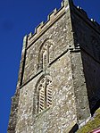 More images |
| Chantry Farm | Marnhull | Farmhouse | 17th century | 4 October 1960 | ST7713818189 50°57′46″N 2°19′37″W / 50.962666°N 2.326913°W / 50.962666; -2.326913 (Chantry Farm) | 1110410 |  More images |
| Senior's Farmhouse and Attached Barn | Marnhull | House | c. 1500 | 4 October 1960 | ST7810218710 50°58′03″N 2°18′48″W / 50.967388°N 2.313218°W / 50.967388; -2.313218 (Senior's Farmhouse and Attached Barn) | 1172057 | 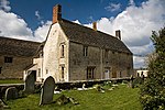 More images |
| Stable/dwelling Range Approximately 10 M South-west of Chantry Farm | Marnhull | Stable/dwelling | 17th century | 4 October 1960 | ST7715018163 50°57′45″N 2°19′36″W / 50.962432°N 2.326741°W / 50.962432; -2.326741 (Stable/dwelling Range Approximately 10 M South-west of Chantry Farm) | 1172053 |  |
| Church of St Thomas | Melbury Abbas | Anglican parish church | 1852 | 16 August 1960 | ST8821020076 50°58′48″N 2°10′10″W / 50.979969°N 2.169318°W / 50.979969; -2.169318 (Church of St Thomas) | 1304933 |  More images |
| Parish Church of Saint Andrew | Milborne St Andrew | Anglican parish church | 15th-century tower | 14 July 1955 | SY8011897401 50°46′33″N 2°17′00″W / 50.775844°N 2.283344°W / 50.775844; -2.283344 (Parish Church of Saint Andrew) | 1118618 |  More images |
| Almshouses and the Reading Room | Milton Abbas | Almshouse | 1674, relocated in 1779 | 14 July 1955 | ST8062501822 50°48′56″N 2°16′35″W / 50.815617°N 2.276388°W / 50.815617; -2.276388 (Almshouses and the Reading Room) | 1118594 |  More images |
| Delcombe Manor | Delcombe, Milton Abbas | Country house | c. 1750 | 14 July 1955 | ST7929004846 50°50′34″N 2°17′44″W / 50.842764°N 2.295509°W / 50.842764; -2.295509 (Delcombe Manor) | 1324251 | Upload Photo |
| Garden House, Delcombe Manor | Delcombe, Milton Abbas | House | c. 1750 | 14 July 1985 | ST7931404812 50°50′33″N 2°17′43″W / 50.842459°N 2.295167°W / 50.842459; -2.295167 (Garden House, Delcombe Manor) | 1151968 | Upload Photo |
| Parish Church of St James | Milton Abbas | Anglican parish church | c. 1786 | 14 July 1955 | ST8064801785 50°48′55″N 2°16′34″W / 50.815285°N 2.27606°W / 50.815285; -2.27606 (Parish Church of St James) | 1118560 |  More images |
| The Old Rectory | Milton Abbas | House | c. 1780 | 14 July 1955 | ST8033501708 50°48′52″N 2°16′50″W / 50.814582°N 2.280498°W / 50.814582; -2.280498 (The Old Rectory) | 1304949 | Upload Photo |
| The Stone Lodge, and the Gatehouse, with Gatepiers and Gates | Milton Abbas | Lodges | Probably c. 1775 | 2 August 1979 | ST8057202958 50°49′33″N 2°16′38″W / 50.825831°N 2.277201°W / 50.825831; -2.277201 (The Stone Lodge, and the Gatehouse, with Gatepiers and Gates) | 1151927 | Upload Photo |
| Church of St Mary | Motcombe | Anglican parish church | 1846 | 16 August 1960 | ST8490925238 51°01′35″N 2°13′00″W / 51.026309°N 2.216555°W / 51.026309; -2.216555 (Church of St Mary) | 1152195 |  More images |
| North End Farmhouse | North End, Motcombe | Farmhouse | 17th century | 3 January 1985 | ST8456827524 51°02′49″N 2°13′17″W / 51.046856°N 2.221516°W / 51.046856; -2.221516 (North End Farmhouse) | 1324606 | Upload Photo |
| Church of St Aldhelm | Belchalwell, Okeford Fitzpaine | Anglican parish church | 15th century | 4 October 1960 | ST7924709803 50°53′14″N 2°17′47″W / 50.887337°N 2.296403°W / 50.887337; -2.296403 (Church of St Aldhelm) | 1216309 |  More images |
| Parish Church of St Andrew | Greenhayes, Okeford Fitzpaine | Anglican parish church | 15th century | 4 September 1960 | ST8073210816 50°53′47″N 2°16′31″W / 50.896498°N 2.275345°W / 50.896498; -2.275345 (Parish Church of St Andrew) | 1216617 |  More images |
| Church of St Peter | Pimperne | Anglican parish church | Mid 15th century | 26 June 1953 | ST9037009415 50°53′03″N 2°08′18″W / 50.884143°N 2.138264°W / 50.884143; -2.138264 (Church of St Peter) | 1110839 |  More images |
| Parish Church of St Thomas a Becket | Pulham | Anglican parish church | 15th century | 4 October 1960 | ST7116908518 50°52′32″N 2°24′40″W / 50.875434°N 2.411138°W / 50.875434; -2.411138 (Parish Church of St Thomas a Becket) | 1228063 |  More images |
| The Old Rectory | Pulham | House | Late 18th century | 7 June 1973 | ST7121208465 50°52′30″N 2°24′38″W / 50.874959°N 2.410523°W / 50.874959; -2.410523 (The Old Rectory) | 1228064 | 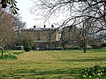 More images |
| Church of St Peter | Shaftesbury | Anglican parish church | Late 15th and early 16th century | 20 June 1952 | ST8628722946 51°00′21″N 2°11′49″W / 51.005734°N 2.196819°W / 51.005734; -2.196819 (Church of St Peter) | 1292132 |  More images |
| Ox House | Shaftesbury | House | Probably late 16th to early 17th century | 20 June 1952 | ST8598222919 51°00′20″N 2°12′04″W / 51.005484°N 2.201165°W / 51.005484; -2.201165 (Ox House) | 1108758 | Upload Photo |
| Pensbury House | Shaftesbury | House | 18th and 19th century | 15 October 1973 | ST8634023552 51°00′40″N 2°11′46″W / 51.011184°N 2.196087°W / 51.011184; -2.196087 (Pensbury House) | 1218389 | Upload Photo |
| The Grosvenor Arms Hotel | Shaftesbury | Hotel | Early 19th century | 20 June 1952 | ST8618822993 51°00′22″N 2°11′54″W / 51.006154°N 2.198232°W / 51.006154; -2.198232 (The Grosvenor Arms Hotel) | 1218032 | Upload Photo |
| Cedar Court | Spetisbury | House | 1716 | 14 July 1955 | ST9104302837 50°49′30″N 2°07′43″W / 50.825001°N 2.128534°W / 50.825001; -2.128534 (Cedar Court) | 1110160 | Upload Photo |
| Church of St Mary | Stalbridge | Anglican parish church | Late 14th century | 4 October 1960 | ST7334618190 50°57′45″N 2°22′51″W / 50.962511°N 2.380908°W / 50.962511; -2.380908 (Church of St Mary) | 1108611 | 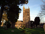 More images |
| Market Cross | Stalbridge | Market cross | Second half of 15th century | 4 October 1960 | ST7349218002 50°57′39″N 2°22′44″W / 50.960827°N 2.378815°W / 50.960827; -2.378815 (Market Cross) | 1153032 |  More images |
| Thornhill House | Thornhill, Stalbridge | Country house | c. 1730 | 4 October 1960 | ST7405814936 50°56′00″N 2°22′14″W / 50.933283°N 2.370537°W / 50.933283; -2.370537 (Thornhill House) | 1324460 |  More images |
| The Manor House | Stoke Wake | House | c. 1700 | 4 October 1960 | ST7645006404 50°51′24″N 2°20′09″W / 50.856664°N 2.335945°W / 50.856664; -2.335945 (The Manor House) | 1228071 | Upload Photo |
| Jolliffe's Farmhouse Including Attached Barn | Stour Provost | House | 17th century | 16 August 1960 | ST8316821805 50°59′43″N 2°14′28″W / 50.99539°N 2.241219°W / 50.99539; -2.241219 (Jolliffe's Farmhouse Including Attached Barn) | 1324535 |  |
| Church of the Holy Trinity | Stourpaine | Anglican parish church | 15th-century tower | 24 June 1985 | ST8603209372 50°53′01″N 2°12′00″W / 50.883667°N 2.199929°W / 50.883667; -2.199929 (Church of the Holy Trinity) | 1305170 | 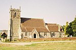 More images |
| Chapel, Approximately 90 Metres West of Manor Farmhouse | Stourton Caundle | Chapel | 13th century | 4 October 1960 | ST7132514929 50°55′59″N 2°24′34″W / 50.93309°N 2.409427°W / 50.93309; -2.409427 (Chapel, Approximately 90 Metres West of Manor Farmhouse) | 1287276 | Upload Photo |
| Sturminster Newton Castle | Sturminster Newton | Manor house | Probably 14th century | 4 October 1960 | ST7846913498 50°55′14″N 2°18′28″W / 50.920535°N 2.307682°W / 50.920535; -2.307682 (Sturminster Newton Castle) | 1324461 | Upload Photo |
| Sturminster Newton Mill | Sturminster Newton | Gristmill | 16th or 17th century | 4 October 1960 | ST7819713519 50°55′15″N 2°18′42″W / 50.920713°N 2.311553°W / 50.920713; -2.311553 (Sturminster Newton Mill) | 1153666 |  More images |
| Church of Saint Bartholomew | Sutton Waldron | Anglican parish church | 1847 | 16 August 1960 | ST8620815705 50°56′26″N 2°11′52″W / 50.940619°N 2.197668°W / 50.940619; -2.197668 (Church of Saint Bartholomew) | 1110209 |  More images |
| Barn and Outbuilding Range 100 Metres North East of Tarrant Abbey House | Tarrant Crawford | Barn | Late 15th century | 26 June 1953 | ST9213103398 50°49′48″N 2°06′47″W / 50.830062°N 2.1131°W / 50.830062; -2.1131 (Barn and Outbuilding Range 100 Metres North East of Tarrant Abbey House) | 1110841 | Upload Photo |
| Tarrant Abbey House | Tarrant Crawford | Box-frame house | 15th century | 26 June 1953 | ST9206103301 50°49′45″N 2°06′51″W / 50.829189°N 2.114092°W / 50.829189; -2.114092 (Tarrant Abbey House) | 1153838 | Upload Photo |
| Church of St Mary | Tarrant Gunville | Anglican parish church | Late 14th century | 14 July 1955 | ST9251912670 50°54′48″N 2°06′28″W / 50.913445°N 2.107783°W / 50.913445; -2.107783 (Church of St Mary) | 1305101 | 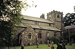 More images |
| Church of All Saints | Tarrant Keyneston | Anglican parish church | 15th-century tower | 26 June 1953 | ST9251604059 50°50′10″N 2°06′28″W / 50.836011°N 2.107647°W / 50.836011; -2.107647 (Church of All Saints) | 1153944 |  More images |
| Church of All Saints | Tarrant Monkton | Anglican parish church | 15th century | 14 July 1955 | ST9439308820 50°52′44″N 2°04′52″W / 50.878846°N 2.081067°W / 50.878846; -2.081067 (Church of All Saints) | 1172540 | 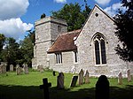 More images |
| Church of St Mary | Tarrant Rawston | Anglican parish church | 14th century | 26 June 1953 | ST9390506666 50°51′34″N 2°05′17″W / 50.859471°N 2.087966°W / 50.859471; -2.087966 (Church of St Mary) | 1154056 | 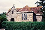 More images |
| Rawston Farmhouse | Tarrant Rawston | Farmhouse | Late 16th or early 17th century | 26 June 1953 | ST9387106663 50°51′34″N 2°05′18″W / 50.859444°N 2.088449°W / 50.859444; -2.088449 (Rawston Farmhouse) | 1324322 |  More images |
| Church of St Mary | Tarrant Rushton | Anglican parish church | 12th century | 26 June 1953 | ST9374306058 50°51′14″N 2°05′25″W / 50.854002°N 2.090257°W / 50.854002; -2.090257 (Church of St Mary) | 1118488 |  More images |
| Church of St Mary | Turnworth | Anglican parish church | 15th-century tower | 14 July 1955 | ST8211707490 50°52′00″N 2°15′20″W / 50.866634°N 2.255488°W / 50.866634; -2.255488 (Church of St Mary) | 1110163 | 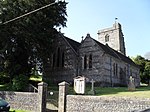 More images |
| Church of St Mary | West Stour | Anglican parish church | 13th century | 16 August 1960 | ST7846422907 51°00′19″N 2°18′30″W / 51.005142°N 2.308313°W / 51.005142; -2.308313 (Church of St Mary) | 1152142 | 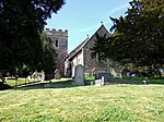 More images |
| Church of St Nicholas | Winterborne Clenston | Anglican parish church | 1840 | 14 July 1955 | ST8398002796 50°49′28″N 2°13′44″W / 50.824479°N 2.228808°W / 50.824479; -2.228808 (Church of St Nicholas) | 1324267 |  More images |
| Church of St Nicholas | Winterborne Kingston | Anglican parish church | 14th century | 14 July 1955 | SY8622597599 50°46′40″N 2°11′48″W / 50.777803°N 2.196739°W / 50.777803; -2.196739 (Church of St Nicholas) | 1152548 |  More images |
| Muston Manor | Winterborne Muston | House | Late 17th century | 10 October 1985 | SY8734097673 50°46′43″N 2°10′51″W / 50.778494°N 2.180928°W / 50.778494; -2.180928 (Muston Manor) | 1304719 | Upload Photo |
| Quarleston Farmhouse | Winterborne Stickland | Farmhouse | 15th century | 14 July 1955 | ST8366303992 50°50′07″N 2°14′00″W / 50.835225°N 2.233363°W / 50.835225; -2.233363 (Quarleston Farmhouse) | 1172390 |  |
| Whatcombe House | Whatcombe, Winterborne Whitechurch | Country house | 1750 | 14 July 1955 | ST8373501295 50°48′40″N 2°13′56″W / 50.810974°N 2.23222°W / 50.810974; -2.23222 (Whatcombe House) | 1118543 |  More images |
See also
Notes
- ^ The date given is the date used by Historic England as significant for the initial building or that of an important part in the structure's description.
- ^ Sometimes known as OSGB36, the grid reference is based on the British national grid reference system used by the Ordnance Survey.
- ^ The "List Entry Number" is a unique number assigned to each listed building and scheduled monument by Historic England.
External links
- v
- t
- e
- Bedfordshire
- Berkshire
- Bristol
- Buckinghamshire
- Cambridgeshire
- Cheshire
- Cornwall
- Cumbria
- Derbyshire
- Devon
- Dorset
- Durham
- East Sussex
- East Riding of Yorkshire
- Essex
- Gloucestershire
- Greater London
- Greater Manchester
- Hampshire
- Herefordshire
- Hertfordshire
- Isle of Wight
- Kent
- Lancashire
- Leicestershire
- Lincolnshire
- Merseyside
- Norfolk
- North Yorkshire
- Northamptonshire
- Northumberland
- Nottinghamshire
- Oxfordshire
- Rutland
- Shropshire
- Somerset
- South Yorkshire
- Staffordshire
- Suffolk
- Surrey
- Tyne and Wear
- Warwickshire
- West Midlands
- West Sussex
- West Yorkshire
- Wiltshire
- Worcestershire
- Allerdale
- Amber Valley
- Ashford
- Babergh
- Barrow-in-Furness
- Basildon
- Basingstoke and Deane
- Bath and North East Somerset
- Bolsover
- Boston
- Bournemouth
- Bradford
- Braintree
- Breckland
- Brentwood
- Brighton and Hove
- Bristol
- Broadland
- Calderdale
- Cambridge
- Camden
- Canterbury
- Carlisle
- Castle Point
- Chelmsford
- Cheltenham
- Cherwell
- Cheshire East
- Cheshire West and Chester
- Chesterfield
- Chiltern
- Christchurch
- Colchester
- Copeland
- Corby
- Cotswold
- Dartford
- Daventry
- Dover
- East Cambridgeshire
- Exeter
- Mendip
- North Somerset
- North Yorkshire (district)
- Poole
- Sedgemoor
- South Somerset
- Stoke-on-Trent
- Taunton Deane
- West Somerset
- York


