Lehndorf-Watenbüttel
Borough of Braunschweig in Lower Saxony, Germany
Location of Lehndorf-Watenbüttel within Braunschweig

52°17′0″N 10°27′45″E / 52.28333°N 10.46250°E / 52.28333; 10.46250
(2020-12-31)[1]
38112, 38114, 38116
Lehndorf-Watenbüttel is a Stadtbezirk (borough) in the northwestern part of Braunschweig, Germany. The Stadtbezirk comprises the quarters Kanzlerfeld, Lamme, Lehndorf, Ölper, Völkenrode, and Watenbüttel.[2]
History
The district consists of several villages that were incorporated into Braunschweig during the 20th century, in 1934 (Lehndorf and Ölper) and in 1974 (Lamme, Völkenrode, and Wattenbüttel),[3] as well as the Kanzlerfeld, a new quarter built in the 1960s.[4]
Politics
The district mayor Frank Graffstedt is a member of the Social Democratic Party of Germany.[5]
Coats of arms
-
 Coat of arms of Lamme
 -
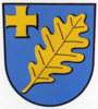
 Coat of arms of Lehndorf
 -
 Coat of arms of Ölper
 -
 Coat of arms of Völkenrode
 -
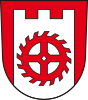
 Coat of arms of Watenbüttel


References
- ^ "Einwohnerzahlen nach Stadtbezirken". Stadt Braunschweig. Retrieved 21 September 2021.
- ^ Stadtbezirke (in German). Retrieved on 1 September 2017.
- ^ "Kreisfreie Stadt Braunschweig" (PDF) (in German). statistik.niedersachsen.de.
- ^ Kanzlerfeld - Trabantenstadt im Grünen (in German). Retrieved on 1 September 2017.
- ^ Stadtbezirksrat im Stadtbezirk 321 Lehndorf-Watenbüttel (in German). Retrieved on 1 September 2017.
Wikimedia Commons has media related to Lehndorf-Watenbüttel.
- v
- t
- e
- 112: Wabe-Schunter-Beberbach
- 113: Hondelage
- 114: Volkmarode
- 120: Östliches Ringgebiet
- 131: Innenstadt
- 132: Viewegsgarten-Bebelhof
- 211: Stöckheim-Leiferde
- 212: Heidberg-Melverode
- 213: Südstadt-Rautheim-Mascherode
- 221: Weststadt
- 222: Timmerlah-Geitelde-Stiddien
- 223: Broitzem
- 224: Rüningen
- 310: Westliches Ringgebiet
- 321: Lehndorf-Watenbüttel
- 322: Veltenhof-Rühme
- 323: Wenden-Thune-Harxbüttel
- 331: Nordstadt
- 332: Schunteraue


