List of crossings of the River Clwyd
The River Clwyd (Welsh: Afon Clwyd) is a river in Wales that rises in the Clocaenog Forest (grid reference SJ045535) 5 mi (8 km) northwest of Corwen. It has many crossings. The Denbigh, Ruthin and Corwen Railway crossed the river seven times and remnants of some of these bridges survive.
| Status | Criteria[1] |
|---|---|
| I | Grade I listed. Bridge of exceptional interest, sometimes considered to be internationally important |
| II* | Grade II* listed. Particularly important bridge of more than special interest |
| II | Grade II listed. Bridge of national importance and special interest |
Map all coordinates using OpenStreetMap
Download coordinates as:
- KML
- GPX (all coordinates)
- GPX (primary coordinates)
- GPX (secondary coordinates)
| Crossing | Date | Coordinates | Heritage status | Locality | Notes | Image |
|---|---|---|---|---|---|---|
| Forest Track | 53°03′49″N 3°27′04″W / 53.0637°N 3.451°W / 53.0637; -3.451 (Clocaenog Forest) | - | Clocaenog Forest | Essentially a drainage pipe | ||
| Minor Road | 53°03′58″N 3°26′05″W / 53.0662°N 3.4346°W / 53.0662; -3.4346 (Clocaenog Forest) | - | Clocaenog Forest | Essentially a drainage pipe | ||
| Waen Ganol Stable Access | 53°03′58″N 3°25′56″W / 53.0662°N 3.4322°W / 53.0662; -3.4322 (Waen Ganol) | - | Clocaenog Forest | |||
| Footbridge | New in 2024 | 53°03′23″N 3°26′08″W / 53.0563°N 3.4356°W / 53.0563; -3.4356 (Footbridge) | - | Clocaenog Forest | Bypasses ford. |  |
| Pont Petryal | 53°03′04″N 3°26′11″W / 53.0511°N 3.4365°W / 53.0511; -3.4365 (Pont Petryal) | - | Clocaenog Forest | B5105 | ||
| Melin-y-Wig Bridge | 53°01′39″N 3°25′59″W / 53.0276°N 3.4331°W / 53.0276; -3.4331 (Melin-y-Wig) | - | Melin-y-Wig | |||
| Local access bridge | 53°01′38″N 3°25′56″W / 53.0271°N 3.4321°W / 53.0271; -3.4321 (Melin-y-Wig) | - | Melin-y-Wig |  | ||
| Footbridge | 53°02′07″N 3°24′47″W / 53.0354°N 3.4131°W / 53.0354; -3.4131 (Glyn-bach) | - | Glyn-bach |  | ||
| Minor Road Bridge | 53°02′29″N 3°22′44″W / 53.0414°N 3.3789°W / 53.0414; -3.3789 (Bryn Saith Marchog) | - | Bryn Saith Marchog | |||
| Farm Access Bridge | 53°02′39″N 3°21′36″W / 53.0443°N 3.3601°W / 53.0443; -3.3601 (Pandy'r Capel) | - | Pandy'r Capel | |||
| Efail-y-plas Bridge[2] | 18th Cent | 53°02′55″N 3°20′55″W / 53.0485°N 3.3487°W / 53.0485; -3.3487 (Efail-y-plas) | II | Derwen | 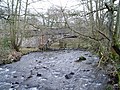 | |
| Farm Access Bridge | 53°03′19″N 3°20′02″W / 53.0553°N 3.334°W / 53.0553; -3.334 (Farm Access Bridge) | - | ||||
| Pont Nant Clwyd | 53°03′27″N 3°19′52″W / 53.0574°N 3.331°W / 53.0574; -3.331 (Pont Nant Clwyd) | - | Llanelidan | A494 | ||
| Pont Nant Clwyd[3] | 1776 | 53°03′27″N 3°19′51″W / 53.0574°N 3.3308°W / 53.0574; -3.3308 (Pont Nant Clwyd) | II | Llanelidan | Old A494 route | 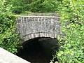 |
| Nantclwyd Hall Bridge[4] | 1965 | 53°03′29″N 3°19′44″W / 53.058°N 3.3289°W / 53.058; -3.3289 (Nantclwyd Hall) | II | Llanelidan | Nantclwyd Hall Access | |
| Footbridge | 53°03′31″N 3°19′40″W / 53.05857°N 3.32777°W / 53.05857; -3.32777 (Footbridge) | - | Llanelidan |  | ||
| Pwllglas Footbridge | 53°04′45″N 3°19′22″W / 53.0793°N 3.3229°W / 53.0793; -3.3229 (Pwllglas Footbridge) | - | Pwllglas |  | ||
| Local Access Bridge | 53°04′48″N 3°19′07″W / 53.08°N 3.3187°W / 53.08; -3.3187 (Pwllglas) | - | Pwllglas | |||
| Local Access Bridge | 53°04′59″N 3°18′51″W / 53.083°N 3.3143°W / 53.083; -3.3143 (Pwllglas) | - | Pwllglas | |||
| Footbridge | 53°05′02″N 3°18′41″W / 53.0838°N 3.3114°W / 53.0838; -3.3114 (Footbridge) | - | Pwllglas | Former Railway Bridge | 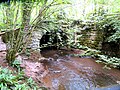 | |
| Pont Eyarth[5] | 17th-18th Cent | 53°05′16″N 3°18′19″W / 53.0877°N 3.3052°W / 53.0877; -3.3052 (Pont Eyarth) | II | Llanfair DC | 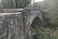 | |
| Farm Access Bridge | 53°06′02″N 3°18′30″W / 53.1005°N 3.3083°W / 53.1005; -3.3083 (Ty'n-y-Wern) | - | Ruthin | Ty'n-y-Wern | ||
| Corwen Road Bridge | 53°06′14″N 3°18′37″W / 53.104°N 3.3104°W / 53.104; -3.3104 (Corwen Road) | - | Ruthin | |||
| Tunnel Bridge[6] | Early 19th Cent | 53°06′31″N 3°18′47″W / 53.1086°N 3.313°W / 53.1086; -3.313 (Tunnel Bridge) | II | Ruthin | Scott House | 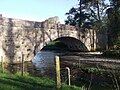 |
| Ruthin Park Bridges | 53°06′42″N 3°18′55″W / 53.1117°N 3.3152°W / 53.1117; -3.3152 (Ruthin Park) | - | Ruthin | 3 Footbridges | 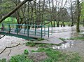 | |
| Pont Howkin | 1771 | 53°06′48″N 3°18′55″W / 53.1133°N 3.3154°W / 53.1133; -3.3154 (Pont Howkin) | II | Ruthin |  | |
| Pont y Plant | 2007 | 53°06′49″N 3°18′53″W / 53.1135°N 3.3147°W / 53.1135; -3.3147 (Pont y Plant) | - | Ruthin | Footbridge | 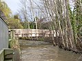 |
| Park Road Bridge | 53°06′56″N 3°18′49″W / 53.1155°N 3.3136°W / 53.1155; -3.3136 (Park Road) | - | Ruthin | 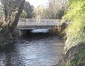 | ||
| Footbridge[7] | Early 19th Cent | 53°06′57″N 3°18′49″W / 53.1159°N 3.3137°W / 53.1159; -3.3137 (Footbridge) | II | Ruthin | 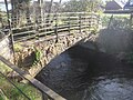 | |
| Ruthin Bypass Bridge | 53°07′15″N 3°18′55″W / 53.1208°N 3.3152°W / 53.1208; -3.3152 (Ruthin Bypass) | - | Ruthin | A525 | 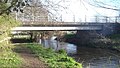 | |
| Water Treatment Access Bridge | 53°07′22″N 3°18′49″W / 53.1227°N 3.3137°W / 53.1227; -3.3137 (Water Treatment) | - | Ruthin |  | ||
| Footbridge | 53°08′04″N 3°18′59″W / 53.1344°N 3.3164°W / 53.1344; -3.3164 (Footbridge) | - | Ruthin |  | ||
| Pont Telpyn[8] | Around 1800 | 53°08′16″N 3°19′04″W / 53.1378°N 3.3177°W / 53.1378; -3.3177 (Pont Telpyn) | II | Rhewl |  | |
| Pont Llanychan[9] | Around 1800 | 53°08′49″N 3°19′37″W / 53.1469°N 3.3269°W / 53.1469; -3.3269 (Pont Llanychan) | II | Rhewl |  | |
| Farm Access Bridge | 53°09′09″N 3°19′56″W / 53.1525°N 3.3321°W / 53.1525; -3.3321 (Gellifor) | - | Gellifor | |||
| Pont Perfa[10] | 17th Cent (or early 18th) | 53°09′31″N 3°20′20″W / 53.1586°N 3.3389°W / 53.1586; -3.3389 (Pont Perfa) | II | Llanynys | 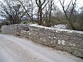 | |
| Pont Clwyd[11] | 18th Cent | 53°10′02″N 3°20′57″W / 53.1673°N 3.3491°W / 53.1673; -3.3491 (Pont Clwyd) | II | Llandyrnog | ||
| Whitchurch Road Bridge | 53°10′56″N 3°21′43″W / 53.1822°N 3.362°W / 53.1822; -3.362 (Whitchurch Road) | - | Denbigh | 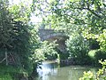 | ||
| Farm Access Bridge | 53°12′28″N 3°22′36″W / 53.2077°N 3.3766°W / 53.2077; -3.3766 (Lleweni Hall) | - | Denbigh | Lleweni Hall |  | |
| Pont Ruffydd[12] | 1784 | 53°12′56″N 3°22′48″W / 53.2156°N 3.3801°W / 53.2156; -3.3801 (Pont Ruffydd) | II | Bodfari | A541 |  |
| Demolished Railway Bridge | 53°13′02″N 3°22′51″W / 53.2173°N 3.3808°W / 53.2173; -3.3808 (Site of Rail Bridge) | - | Mold and Denbigh Junction Railway | Now Demolished |  | |
| Pont-y-cambwll[13] | Late 16th Cent | 53°13′39″N 3°23′35″W / 53.2275°N 3.3931°W / 53.2275; -3.3931 (Pont-y-cambwll) | II | Bodfari |  | |
| Pont Llannerch[14] | Around 1800 | 53°14′11″N 3°24′40″W / 53.2363°N 3.4112°W / 53.2363; -3.4112 (Pont Llannerch) | II | Trefnant | Washed away Jan 2021 (historic photo) |  |
| Footbridge | 53°14′25″N 3°24′55″W / 53.2402°N 3.4152°W / 53.2402; -3.4152 (Llannerch_Hall) | - | Llannerch_Hall | |||
| Footbridge | 53°15′00″N 3°25′22″W / 53.2499°N 3.4227°W / 53.2499; -3.4227 (Footbridge) | - | St Asaph | 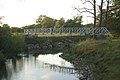 | ||
| Chester St Bridge | 53°15′43″N 3°26′02″W / 53.262°N 3.4339°W / 53.262; -3.4339 (St Asaph) | - | St Asaph | A525 | 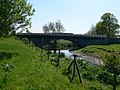 | |
| A55 Bridge | 53°15′46″N 3°26′07″W / 53.2628°N 3.4352°W / 53.2628; -3.4352 (A55) | - | St Asaph | A55 |  | |
| Pont Dafydd[15] | 1630 | 53°15′49″N 3°26′06″W / 53.2637°N 3.4349°W / 53.2637; -3.4349 (Pont Dafydd) | II | St Asaph | Marooned following rerouting of river | 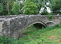 |
| Rhuddlan Bridge[16] | 1595, subsequent alterations | 53°17′24″N 3°28′08″W / 53.2899°N 3.4688°W / 53.2899; -3.4688 (Rhuddlan Bridge) | II* | Rhuddlan |  | |
| Rhuddlan Footbridge | 53°17′24″N 3°28′08″W / 53.29°N 3.469°W / 53.29; -3.469 (Rhuddlan Footbridge) | - | Rhuddlan | 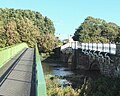 | ||
| A525 bridge | 53°17′28″N 3°28′21″W / 53.2911°N 3.4726°W / 53.2911; -3.4726 (A525) | - | Rhuddlan | A525 |  | |
| Foryd Bridge | 53°18′34″N 3°30′22″W / 53.3094°N 3.5061°W / 53.3094; -3.5061 (Foryd Bridge) | - | North Wales Main Line |  | ||
| Foryd Harbour Bridge[17] | 1932 | 53°18′47″N 3°30′38″W / 53.313°N 3.5105°W / 53.313; -3.5105 (Foryd Harbour Bridge) | II | Kinmel Bay | 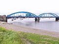 | |
| Pont y Ddraig | 2013 | 53°18′54″N 3°30′28″W / 53.3149°N 3.5079°W / 53.3149; -3.5079 (Pont y Ddraig) | - | Kinmel Bay | Lifting footbridge | 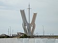 |
References
- ^ Listed Buildings, English Heritage, archived from the original on 9 December 2012, retrieved 22 April 2011
- ^ British Listed Buildings
- ^ British Listed Buildings
- ^ British Listed Buildings
- ^ British Listed Buildings
- ^ British Listed Buildings
- ^ British Listed Buildings
- ^ British Listed Buildings
- ^ British Listed Buildings
- ^ British Listed Buildings
- ^ British Listed Buildings
- ^ British Listed Buildings
- ^ British Listed Buildings
- ^ British Listed Buildings
- ^ British Listed Buildings
- ^ British Listed Buildings
- ^ British Listed Buildings


