List of listed buildings in East Linton, East Lothian
This is a list of listed buildings in the parish of East Linton in East Lothian, Scotland.
Map all coordinates using OpenStreetMap
Download coordinates as:
- KML
- GPX (all coordinates)
- GPX (primary coordinates)
- GPX (secondary coordinates)
List
| Name | Location | Date Listed | Grid Ref. [note 1] | Geo-coordinates | Notes | LB Number [note 2] | Image |
|---|---|---|---|---|---|---|---|
| 3-7 (Odd Nos) Bridge Street | 55°59′07″N 2°39′23″W / 55.98525°N 2.65638°W / 55.98525; -2.65638 (3-7 (Odd Nos) Bridge Street) | Category B | 26637 |  Upload another image | |||
| 19 and 21 Bridge Street | 55°59′09″N 2°39′23″W / 55.985699°N 2.656404°W / 55.985699; -2.656404 (19 and 21 Bridge Street) | Category B | 26639 |  Upload Photo | |||
| 25 Bridge Street, The Crown Hotel | 55°59′10″N 2°39′22″W / 55.986069°N 2.656202°W / 55.986069; -2.656202 (25 Bridge Street, The Crown Hotel) | Category B | 26641 |  Upload another image | |||
| 4 Browns Place, with Retaining Wall | 55°59′20″N 2°39′32″W / 55.988885°N 2.658926°W / 55.988885; -2.658926 (4 Browns Place, with Retaining Wall) | Category C(S) | 26645 | Upload Photo | |||
| 45 High Street | 55°59′15″N 2°39′25″W / 55.987593°N 2.656917°W / 55.987593; -2.656917 (45 High Street) | Category C(S) | 26666 |  Upload another image | |||
| 2 High Street | 55°59′11″N 2°39′21″W / 55.986521°N 2.655697°W / 55.986521; -2.655697 (2 High Street) | Category C(S) | 26672 | Upload Photo | |||
| 32 High Street | 55°59′14″N 2°39′22″W / 55.987354°N 2.656224°W / 55.987354; -2.656224 (32 High Street) | Category C(S) | 26675 |  Upload another image | |||
| 1 Lauder Place | 55°59′04″N 2°39′14″W / 55.98458°N 2.653981°W / 55.98458; -2.653981 (1 Lauder Place) | Category B | 26679 | Upload Photo | |||
| 1 Preston Road | 55°59′21″N 2°39′30″W / 55.989076°N 2.658417°W / 55.989076; -2.658417 (1 Preston Road) | Category B | 26683 |  Upload another image | |||
| 5 Bridge End | 55°59′08″N 2°39′17″W / 55.985421°N 2.654668°W / 55.985421; -2.654668 (5 Bridge End) | Category B | 26634 |  Upload another image | |||
| 23 Bridge Street | 55°59′09″N 2°39′22″W / 55.98597°N 2.656216°W / 55.98597; -2.656216 (23 Bridge Street) | Category B | 26640 | Upload Photo | |||
| 3 High Street | 55°59′11″N 2°39′22″W / 55.986321°N 2.65611°W / 55.986321; -2.65611 (3 High Street) | Category C(S) | 26656 | Upload Photo | |||
| 15 High Street | 55°59′12″N 2°39′22″W / 55.986608°N 2.656195°W / 55.986608; -2.656195 (15 High Street) | Category B | 26659 | Upload Photo | |||
| 21 and 23 High Street | 55°59′12″N 2°39′23″W / 55.986787°N 2.656326°W / 55.986787; -2.656326 (21 and 23 High Street) | Category C(S) | 26661 |  Upload another image | |||
| 40 and 42 High Street | 55°59′17″N 2°39′23″W / 55.987937°N 2.65641°W / 55.987937; -2.65641 (40 and 42 High Street) | Category C(S) | 26676 | Upload Photo | |||
| 44 and 46 High Street | 55°59′16″N 2°39′24″W / 55.98781°N 2.656568°W / 55.98781; -2.656568 (44 and 46 High Street) | Category C(S) | 26677 |  Upload another image | |||
| 9 Brown's Place | 55°59′22″N 2°39′35″W / 55.98932°N 2.659831°W / 55.98932; -2.659831 (9 Brown's Place) | Category B | 26649 | Upload Photo | |||
| 11-13 (Inclusive Nos) Brown's Place | 55°59′22″N 2°39′36″W / 55.989426°N 2.660138°W / 55.989426; -2.660138 (11-13 (Inclusive Nos) Brown's Place) | Category C(S) | 26651 | Upload Photo | |||
| 7 and 9 High Street | 55°59′11″N 2°39′22″W / 55.98642°N 2.65616°W / 55.98642; -2.65616 (7 and 9 High Street) | Category B | 26657 | Upload Photo | |||
| 47 and 49 High Street | 55°59′16″N 2°39′25″W / 55.987682°N 2.656982°W / 55.987682; -2.656982 (47 and 49 High Street) | Category B | 26667 |  Upload another image | |||
| 65 High Street | 55°59′11″N 2°39′27″W / 55.986457°N 2.657587°W / 55.986457; -2.657587 (65 High Street) | Category B | 26668 |  Upload another image | |||
| 71 High Street | 55°59′18″N 2°39′28″W / 55.988225°N 2.657873°W / 55.988225; -2.657873 (71 High Street) | Category C(S) | 26671 |  Upload another image | |||
| Bank Road, The Royal Bank Of Scotland | 55°59′10″N 2°39′26″W / 55.986037°N 2.657099°W / 55.986037; -2.657099 (Bank Road, The Royal Bank Of Scotland) | Category B | 26631 |  Upload another image | |||
| Bridge End, Old Bridge | 55°59′07″N 2°39′16″W / 55.985233°N 2.654521°W / 55.985233; -2.654521 (Bridge End, Old Bridge) | Category A | 26632 |  Upload another image | |||
| 1 Bridge Street | 55°59′07″N 2°39′23″W / 55.98517°N 2.656315°W / 55.98517; -2.656315 (1 Bridge Street) | Category B | 26636 |  Upload another image | |||
| 16 and 17 Brown's Place | 55°59′23″N 2°39′39″W / 55.989639°N 2.660735°W / 55.989639; -2.660735 (16 and 17 Brown's Place) | Category C(S) | 26652 | Upload Photo | |||
| 69 High Street | 55°59′17″N 2°39′28″W / 55.988172°N 2.657776°W / 55.988172; -2.657776 (69 High Street) | Category B | 26670 | Upload Photo | |||
| 8 High Street, Old Bankhouse | 55°59′12″N 2°39′20″W / 55.986728°N 2.655604°W / 55.986728; -2.655604 (8 High Street, Old Bankhouse) | Category B | 26674 |  Upload another image | |||
| 2 Preston Road | 55°59′21″N 2°39′29″W / 55.989185°N 2.658162°W / 55.989185; -2.658162 (2 Preston Road) | Category B | 26684 | Upload Photo | |||
| 5-12 (Inclusive Nos) School Road | 55°59′15″N 2°39′30″W / 55.987451°N 2.658229°W / 55.987451; -2.658229 (5-12 (Inclusive Nos) School Road) | Category B | 26686 |  Upload another image | |||
| 10-14 (Even Nos) Bridge Street | 55°59′09″N 2°39′21″W / 55.985882°N 2.655894°W / 55.985882; -2.655894 (10-14 (Even Nos) Bridge Street) | Category C(S) | 26644 |  Upload another image | |||
| 6 and 7 Brown's Place, with Retaining Wall and Railings | 55°59′20″N 2°39′33″W / 55.988973°N 2.65912°W / 55.988973; -2.65912 (6 and 7 Brown's Place, with Retaining Wall and Railings) | Category C(S) | 26647 |  Upload another image | |||
| 8 Brown's Place, Old North Manse | 55°59′21″N 2°39′34″W / 55.989241°N 2.659574°W / 55.989241; -2.659574 (8 Brown's Place, Old North Manse) | Category B | 26648 | Upload Photo | |||
| 18-21 (Inclusive Nos) Brown's Place | 55°59′23″N 2°39′40″W / 55.989682°N 2.661088°W / 55.989682; -2.661088 (18-21 (Inclusive Nos) Brown's Place) | Category C(S) | 26653 | Upload Photo | |||
| 29 High Street | 55°59′13″N 2°39′23″W / 55.98703°N 2.656346°W / 55.98703; -2.656346 (29 High Street) | Category C(S) | 26664 |  Upload another image | |||
| 4 and 6 High Street | 55°59′12″N 2°39′21″W / 55.986566°N 2.655745°W / 55.986566; -2.655745 (4 and 6 High Street) | Category C(S) | 26673 |  Upload another image | |||
| 2 and 3 The Square | 55°59′10″N 2°39′21″W / 55.986071°N 2.655785°W / 55.986071; -2.655785 (2 and 3 The Square) | Category C(S) | 26687 |  Upload another image | |||
| 7 The Square, Manor House | 55°59′11″N 2°39′20″W / 55.986342°N 2.655517°W / 55.986342; -2.655517 (7 The Square, Manor House) | Category B | 26689 |  Upload another image | |||
| The Square, St Andrews's Church, Church Of Scotland | 55°59′09″N 2°39′19″W / 55.98593°N 2.655334°W / 55.98593; -2.655334 (The Square, St Andrews's Church, Church Of Scotland) | Category B | 26690 |  Upload another image | |||
| 4 Bridge End, Old Bakehouse | 55°59′08″N 2°39′18″W / 55.985528°N 2.654862°W / 55.985528; -2.654862 (4 Bridge End, Old Bakehouse) | Category C(S) | 26635 |  Upload another image | |||
| 5 Browns Place, with Retaining Wall | 55°59′20″N 2°39′32″W / 55.988929°N 2.659007°W / 55.988929; -2.659007 (5 Browns Place, with Retaining Wall) | Category B | 26646 | Upload Photo | |||
| 23 Brown's Place | 55°59′24″N 2°39′42″W / 55.989948°N 2.66167°W / 55.989948; -2.66167 (23 Brown's Place) | Category B | 26654 |  Upload another image | |||
| Station Road, Manseford | 55°59′05″N 2°39′22″W / 55.984721°N 2.656147°W / 55.984721; -2.656147 (Station Road, Manseford) | Category C(S) | 26693 | Upload Photo | |||
| Station Road, Station House | 55°59′06″N 2°39′24″W / 55.985033°N 2.656761°W / 55.985033; -2.656761 (Station Road, Station House) | Category B | 26694 |  Upload another image | |||
| 2 Bridge Street Old Polling Station | 55°59′08″N 2°39′21″W / 55.985452°N 2.65571°W / 55.985452; -2.65571 (2 Bridge Street Old Polling Station) | Category B | 26642 |  Upload another image | |||
| 6 Bridge Street, Lynton Cottage | 55°59′08″N 2°39′21″W / 55.985693°N 2.655923°W / 55.985693; -2.655923 (6 Bridge Street, Lynton Cottage) | Category C(S) | 26643 |  Upload another image | |||
| 10 Brown's Place | 55°59′22″N 2°39′36″W / 55.989418°N 2.659977°W / 55.989418; -2.659977 (10 Brown's Place) | Category B | 26650 | Upload Photo | |||
| 11 and 13 High Street | 55°59′12″N 2°39′22″W / 55.986536°N 2.656178°W / 55.986536; -2.656178 (11 and 13 High Street) | Category B | 26658 | Upload Photo | |||
| 17 and 19 High Street | 55°59′12″N 2°39′22″W / 55.986671°N 2.656228°W / 55.986671; -2.656228 (17 and 19 High Street) | Category B | 26660 | Upload Photo | |||
| High Street, Telephone Kiosk | 55°59′12″N 2°39′22″W / 55.986743°N 2.656133°W / 55.986743; -2.656133 (High Street, Telephone Kiosk) | Category B | 26662 | 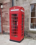 Upload another image | |||
| 43 High Street | 55°59′15″N 2°39′24″W / 55.98753°N 2.656804°W / 55.98753; -2.656804 (43 High Street) | Category B | 26665 |  Upload another image | |||
| High Street, Prestonkirk House | 55°59′19″N 2°39′26″W / 55.988732°N 2.657273°W / 55.988732; -2.657273 (High Street, Prestonkirk House) | Category B | 26678 | Upload Photo | |||
| 6 Mill Wynd | 55°59′09″N 2°39′18″W / 55.985923°N 2.654965°W / 55.985923; -2.654965 (6 Mill Wynd) | Category B | 26682 |  Upload another image | |||
| The Square Fountain | 55°59′10″N 2°39′21″W / 55.986242°N 2.65582°W / 55.986242; -2.65582 (The Square Fountain) | Category B | 26691 | 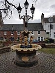 Upload another image | |||
| Haddington Road, Old Auction Mart Sale Hall | 55°59′08″N 2°39′35″W / 55.98543°N 2.659829°W / 55.98543; -2.659829 (Haddington Road, Old Auction Mart Sale Hall) | Category B | 48089 |  Upload another image | |||
| 1 Bridge End | 55°59′07″N 2°39′19″W / 55.985257°N 2.655194°W / 55.985257; -2.655194 (1 Bridge End) | Category B | 26633 |  Upload another image | |||
| 9 and 11 Bridge Street | 55°59′08″N 2°39′23″W / 55.98552°N 2.656337°W / 55.98552; -2.656337 (9 and 11 Bridge Street) | Category C(S) | 26638 | Upload Photo | |||
| 1 High Street | 55°59′10″N 2°39′22″W / 55.986249°N 2.656125°W / 55.986249; -2.656125 (1 High Street) | Category C(S) | 26655 | Upload Photo | |||
| 25 High Street | 56°00′17″N 2°39′24″W / 56.004826°N 2.656744°W / 56.004826; -2.656744 (25 High Street) | Category C(S) | 26663 |  Upload another image | |||
| 67 High Street | 55°59′17″N 2°39′28″W / 55.988046°N 2.657742°W / 55.988046; -2.657742 (67 High Street) | Category C(S) | 26669 | Upload Photo | |||
| 3 Mill Wynd | 55°59′11″N 2°39′17″W / 55.986266°N 2.654682°W / 55.986266; -2.654682 (3 Mill Wynd) | Category B | 26680 |  Upload another image | |||
| 5 Mill Wynd | 55°59′10″N 2°39′18″W / 55.986012°N 2.655015°W / 55.986012; -2.655015 (5 Mill Wynd) | Category C(S) | 26681 | Upload Photo | |||
| 5 Preston Road | 55°59′23″N 2°39′27″W / 55.989666°N 2.657369°W / 55.989666; -2.657369 (5 Preston Road) | Category B | 26685 |  Upload another image | |||
| 4 The Square | 55°59′10″N 2°39′20″W / 55.986099°N 2.655673°W / 55.986099; -2.655673 (4 The Square) | Category B | 26688 |  Upload another image | |||
| Station Road, Harvesters Hotel | 55°59′03″N 2°39′25″W / 55.984178°N 2.656923°W / 55.984178; -2.656923 (Station Road, Harvesters Hotel) | Category B | 26692 |  Upload another image |
Key
The scheme for classifying buildings in Scotland is:
- Category A: "buildings of national or international importance, either architectural or historic; or fine, little-altered examples of some particular period, style or building type."[1]
- Category B: "buildings of regional or more than local importance; or major examples of some particular period, style or building type, which may have been altered."[1]
- Category C: "buildings of local importance; lesser examples of any period, style, or building type, as originally constructed or moderately altered; and simple traditional buildings which group well with other listed buildings."[1]
In March 2016 there were 47,288 listed buildings in Scotland. Of these, 8% were Category A, and 50% were Category B, with the remaining 42% being Category C.[2]
See also
Notes
- ^ Sometimes known as OSGB36, the grid reference (where provided) is based on the British national grid reference system used by the Ordnance Survey.
• "Guide to National Grid". Ordnance Survey. Retrieved 12 December 2007.
• "Get-a-map". Ordnance Survey. Retrieved 17 December 2007. - ^ Historic Environment Scotland assign a unique alphanumeric identifier to each designated site in Scotland, for listed buildings this always begins with "LB", for example "LB12345".
References
- All entries, addresses and coordinates are based on data from Historic Scotland. This data falls under the Open Government Licence
- ^ a b c "What is Listing?". Historic Environment Scotland. Retrieved 29 May 2018.
- ^ Scotland's Historic Environment Audit 2016 (PDF). Historic Environment Scotland and the Built Environment Forum Scotland. pp. 15–16. Retrieved 29 May 2018.


