List of listed buildings in Monimail, Fife
This is a list of listed buildings in the parish of Monimail in Fife, Scotland.
Map all coordinates using OpenStreetMap
Download coordinates as:
- KML
- GPX (all coordinates)
- GPX (primary coordinates)
- GPX (secondary coordinates)
List
| Name | Location | Date Listed | Grid Ref. [note 1] | Geo-coordinates | Notes | LB Number [note 2] | Image |
|---|---|---|---|---|---|---|---|
| Letham 1-5 (Odd Nos) School Brae | 56°19′03″N 3°07′18″W / 56.317505°N 3.121779°W / 56.317505; -3.121779 (Letham 1-5 (Odd Nos) School Brae) | Category C(S) | 19230 |  Upload Photo | |||
| Rankeilour Bridge Over Rankeilour Burn | 56°17′40″N 3°05′16″W / 56.294403°N 3.087801°W / 56.294403; -3.087801 (Rankeilour Bridge Over Rankeilour Burn) | Category C(S) | 19134 | Upload Photo | |||
| Mount Hill, Hopetoun Monument (To Sir John Hope Of Over Rankeilour) | 56°20′10″N 3°05′01″W / 56.335975°N 3.083711°W / 56.335975; -3.083711 (Mount Hill, Hopetoun Monument (To Sir John Hope Of Over Rankeilour)) | Category B | 17428 | Upload Photo | |||
| Lindifferon Farmhouse, Gatepiers And Steading | 56°20′05″N 3°06′30″W / 56.334652°N 3.108421°W / 56.334652; -3.108421 (Lindifferon Farmhouse, Gatepiers And Steading) | Category B | 15447 | Upload Photo | |||
| Melville House North Lodge And Gatepiers | 56°18′52″N 3°08′03″W / 56.314472°N 3.134187°W / 56.314472; -3.134187 (Melville House North Lodge And Gatepiers) | Category B | 15450 | Upload Photo | |||
| Fernie Castle Ice House | 56°19′15″N 3°06′26″W / 56.320718°N 3.107225°W / 56.320718; -3.107225 (Fernie Castle Ice House) | Category C(S) | 15475 | Upload Photo | |||
| Letham Village Letham Lands Farmhouse Steading And Former Horsemill | 56°19′03″N 3°07′15″W / 56.317406°N 3.120871°W / 56.317406; -3.120871 (Letham Village Letham Lands Farmhouse Steading And Former Horsemill) | Category B | 15478 | Upload Photo | |||
| Monimail Village The Old Mill | 56°18′57″N 3°08′19″W / 56.315967°N 3.138661°W / 56.315967; -3.138661 (Monimail Village The Old Mill) | Category B | 15483 | Upload Photo | |||
| Monimail Quarry Monument At The Ladies' Seat | 56°19′07″N 3°08′19″W / 56.318655°N 3.138531°W / 56.318655; -3.138531 (Monimail Quarry Monument At The Ladies' Seat) | Category C(S) | 15484 | Upload Photo | |||
| Nisbetfield Farmhouse And Steading | 56°19′01″N 3°07′51″W / 56.316839°N 3.130797°W / 56.316839; -3.130797 (Nisbetfield Farmhouse And Steading) | Category B | 15485 | Upload Photo | |||
| Over Rankeilour Home Farm And Gatepiers | 56°18′18″N 3°05′15″W / 56.304873°N 3.08742°W / 56.304873; -3.08742 (Over Rankeilour Home Farm And Gatepiers) | Category B | 15489 | Upload Photo | |||
| Rankeilour Mains Farmhouse, Steading, Cartshed And Cottage | 56°17′43″N 3°05′14″W / 56.29535°N 3.087311°W / 56.29535; -3.087311 (Rankeilour Mains Farmhouse, Steading, Cartshed And Cottage) | Category B | 15490 | Upload Photo | |||
| Monimail Parish Church | 56°18′53″N 3°07′47″W / 56.314631°N 3.129584°W / 56.314631; -3.129584 (Monimail Parish Church) | Category B | 15497 |  Upload another image | |||
| Uthrogle Farm, Cupar Racecourse Stand | 56°18′28″N 3°03′53″W / 56.307774°N 3.064858°W / 56.307774; -3.064858 (Uthrogle Farm, Cupar Racecourse Stand) | Category C(S) | 44599 | Upload Photo | |||
| Letham Village West End St Margaret's St Cuthbert's (Formerly Helenslea) Ballacraine Cluny | 56°19′01″N 3°07′18″W / 56.317074°N 3.121783°W / 56.317074; -3.121783 (Letham Village West End St Margaret's St Cuthbert's (Formerly Helenslea) Ballacraine Cluny) | Category C(S) | 15443 | Upload Photo | |||
| Letham Village West End The Brae | 56°18′59″N 3°07′25″W / 56.316491°N 3.123625°W / 56.316491; -3.123625 (Letham Village West End The Brae) | Category C(S) | 15446 | Upload Photo | |||
| Melville House Pavilion Blocks And Lodges | 56°18′41″N 3°08′05″W / 56.311411°N 3.134807°W / 56.311411; -3.134807 (Melville House Pavilion Blocks And Lodges) | Category A | 15448 | 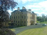 Upload another image | |||
| Bow Of Fife Pitlessie Road Manse | 56°18′10″N 3°05′59″W / 56.302733°N 3.09982°W / 56.302733; -3.09982 (Bow Of Fife Pitlessie Road Manse) | Category C(S) | 15467 | Upload Photo | |||
| Over Rankeilour House, Octagonal Enclosure, And Garage And Gatepiers | 56°18′36″N 3°05′13″W / 56.310034°N 3.087066°W / 56.310034; -3.087066 (Over Rankeilour House, Octagonal Enclosure, And Garage And Gatepiers) | Category A | 15486 | Upload Photo | |||
| Letham Village, Mr Cameron (West Of And Adjoining Letham Lands) | 56°19′03″N 3°07′16″W / 56.317395°N 3.121081°W / 56.317395; -3.121081 (Letham Village, Mr Cameron (West Of And Adjoining Letham Lands)) | Category B | 17426 | Upload Photo | |||
| Letham Village West End, Melville Place Upper Melville Place Cargill House And West View | 56°19′00″N 3°07′23″W / 56.316585°N 3.123191°W / 56.316585; -3.123191 (Letham Village West End, Melville Place Upper Melville Place Cargill House And West View) | Category C(S) | 15445 | Upload Photo | |||
| Melville House Monument To West Of Walled Garden | 56°18′52″N 3°08′16″W / 56.314467°N 3.137727°W / 56.314467; -3.137727 (Melville House Monument To West Of Walled Garden) | Category B | 15449 | Upload Photo | |||
| Ballantager Farm-House And Steading | 56°18′40″N 3°07′09″W / 56.311195°N 3.119073°W / 56.311195; -3.119073 (Ballantager Farm-House And Steading) | Category B | 15464 | Upload Photo | |||
| Cunnoquhie House | 56°19′28″N 3°06′44″W / 56.324429°N 3.112248°W / 56.324429; -3.112248 (Cunnoquhie House) | Category A | 15469 | Upload Photo | |||
| Fernie Castle Bridge At Main Drive | 56°19′10″N 3°06′34″W / 56.319557°N 3.109438°W / 56.319557; -3.109438 (Fernie Castle Bridge At Main Drive) | Category C(S) | 15474 | Upload Photo | |||
| Letham Village Schoolhouse | 56°19′09″N 3°07′22″W / 56.31924°N 3.122719°W / 56.31924; -3.122719 (Letham Village Schoolhouse) | Category B | 15482 | Upload Photo | |||
| Cunnoquhie Former Stable Block | 56°19′28″N 3°06′48″W / 56.324482°N 3.113333°W / 56.324482; -3.113333 (Cunnoquhie Former Stable Block) | Category A | 19749 | Upload Photo | |||
| Monimail Cemetery Walls And Gatepiers, And Fragments Of Old Church And North Aisle | 56°18′53″N 3°08′09″W / 56.314637°N 3.135776°W / 56.314637; -3.135776 (Monimail Cemetery Walls And Gatepiers, And Fragments Of Old Church And North Aisle) | Category B | 19133 | Upload Photo | |||
| Letham Village, Dovecote To North Of School Brae | 56°19′08″N 3°07′26″W / 56.31877°N 3.123934°W / 56.31877; -3.123934 (Letham Village, Dovecote To North Of School Brae) | Category B | 17427 | Upload Photo | |||
| Bow Of Fife Church | 56°18′12″N 3°06′01″W / 56.303285°N 3.100385°W / 56.303285; -3.100385 (Bow Of Fife Church) | Category C(S) | 15466 | Upload Photo | |||
| Cunnoquhie Garden Walls And Gardener's Cottage | 56°19′24″N 3°06′48″W / 56.323223°N 3.113458°W / 56.323223; -3.113458 (Cunnoquhie Garden Walls And Gardener's Cottage) | Category C(S) | 15471 | Upload Photo | |||
| Fernie Castle Garden Walls | 56°19′14″N 3°06′09″W / 56.320679°N 3.102486°W / 56.320679; -3.102486 (Fernie Castle Garden Walls) | Category C(S) | 15473 | Upload Photo | |||
| Rankeilour, East Lodge And Gatepiers | 56°18′00″N 3°04′24″W / 56.30002°N 3.073239°W / 56.30002; -3.073239 (Rankeilour, East Lodge And Gatepiers) | Category B | 15491 | Upload Photo | |||
| Fernie Castle Stable Blocks And Kennels | 56°19′17″N 3°06′11″W / 56.321429°N 3.103074°W / 56.321429; -3.103074 (Fernie Castle Stable Blocks And Kennels) | Category B | 15476 | Upload Photo | |||
| Letham Village School Brae Dovecot | 56°19′06″N 3°07′21″W / 56.318352°N 3.122467°W / 56.318352; -3.122467 (Letham Village School Brae Dovecot) | Category B | 15481 | Upload Photo | |||
| St Mary's Farmhouse And Steading | 56°19′23″N 3°03′30″W / 56.323078°N 3.05825°W / 56.323078; -3.05825 (St Mary's Farmhouse And Steading) | Category B | 15492 | Upload Photo | |||
| Monimail Tower Or Palace (Also Known As Cardinal Beaton's Tower) And Melville House Garden Walls | 56°18′50″N 3°08′09″W / 56.314017°N 3.135758°W / 56.314017; -3.135758 (Monimail Tower Or Palace (Also Known As Cardinal Beaton's Tower) And Melville House Garden Walls) | Category A | 15498 |  Upload another image | |||
| Rankeilour Dovecote | 56°17′43″N 3°05′05″W / 56.295301°N 3.084757°W / 56.295301; -3.084757 (Rankeilour Dovecote) | Category B | 19135 | Upload Photo | |||
| Barham House | 56°18′06″N 3°06′20″W / 56.301784°N 3.105481°W / 56.301784; -3.105481 (Barham House) | Category B | 15465 | Upload Photo | |||
| Fernie Castle Hotel | 56°19′14″N 3°06′26″W / 56.320485°N 3.107121°W / 56.320485; -3.107121 (Fernie Castle Hotel) | Category B | 15472 | Upload Photo | |||
| Over Rankeilour House Former Stables And Cottage To North | 56°18′32″N 3°05′23″W / 56.308834°N 3.089682°W / 56.308834; -3.089682 (Over Rankeilour House Former Stables And Cottage To North) | Category C(S) | 15487 | Upload Photo | |||
| Over Rankeilour House Garden Walls | 56°18′34″N 3°05′37″W / 56.309427°N 3.093692°W / 56.309427; -3.093692 (Over Rankeilour House Garden Walls) | Category C(S) | 15488 | Upload Photo | |||
| Pathcondie Farmhouse | 56°19′00″N 3°08′39″W / 56.316573°N 3.144159°W / 56.316573; -3.144159 (Pathcondie Farmhouse) | Category B | 19750 | Upload Photo | |||
| Carslogie Dovecot | 56°19′02″N 3°03′10″W / 56.317105°N 3.05275°W / 56.317105; -3.05275 (Carslogie Dovecot) | Category C(S) | 15468 | Upload Photo | |||
| Cunnoquhie Lodge And Gatepiers | 56°19′21″N 3°06′24″W / 56.322519°N 3.106727°W / 56.322519; -3.106727 (Cunnoquhie Lodge And Gatepiers) | Category B | 15470 | Upload Photo | |||
| Letham Village Letham Lands Former Bakehouse | 56°19′03″N 3°07′16″W / 56.317438°N 3.121228°W / 56.317438; -3.121228 (Letham Village Letham Lands Former Bakehouse) | Category C(S) | 15479 | Upload Photo | |||
| Letham Village West End Balyarrow | 56°19′00″N 3°07′21″W / 56.316779°N 3.122615°W / 56.316779; -3.122615 (Letham Village West End Balyarrow) | Category C(S) | 15444 | Upload Photo | |||
| Letham Village Balmerino Cottage And Garden Walls | 56°19′06″N 3°07′24″W / 56.31838°N 3.123438°W / 56.31838; -3.123438 (Letham Village Balmerino Cottage And Garden Walls) | Category B | 15477 | Upload Photo | |||
| Letham Village Letham Lands Dovecot | 56°19′03″N 3°07′16″W / 56.31753°N 3.121036°W / 56.31753; -3.121036 (Letham Village Letham Lands Dovecot) | Category B | 15480 | Upload Photo |
Key
The scheme for classifying buildings in Scotland is:
- Category A: "buildings of national or international importance, either architectural or historic; or fine, little-altered examples of some particular period, style or building type."[1]
- Category B: "buildings of regional or more than local importance; or major examples of some particular period, style or building type, which may have been altered."[1]
- Category C: "buildings of local importance; lesser examples of any period, style, or building type, as originally constructed or moderately altered; and simple traditional buildings which group well with other listed buildings."[1]
In March 2016 there were 47,288 listed buildings in Scotland. Of these, 8% were Category A, and 50% were Category B, with the remaining 42% being Category C.[2]
See also
Notes
- ^ Sometimes known as OSGB36, the grid reference (where provided) is based on the British national grid reference system used by the Ordnance Survey.
• "Guide to National Grid". Ordnance Survey. Retrieved 12 December 2007.
• "Get-a-map". Ordnance Survey. Retrieved 17 December 2007. - ^ Historic Environment Scotland assign a unique alphanumeric identifier to each designated site in Scotland, for listed buildings this always begins with "LB", for example "LB12345".
References
- All entries, addresses and coordinates are based on data from Historic Scotland. This data falls under the Open Government Licence
- ^ a b c "What is Listing?". Historic Environment Scotland. Retrieved 29 May 2018.
- ^ Scotland's Historic Environment Audit 2016 (PDF). Historic Environment Scotland and the Built Environment Forum Scotland. pp. 15–16. Retrieved 29 May 2018.


