Lutovynivka
Village in Poltava Oblast, Ukraine
You can help expand this article with text translated from the corresponding article in Ukrainian. (August 2018) Click [show] for important translation instructions.
- Machine translation, like DeepL or Google Translate, is a useful starting point for translations, but translators must revise errors as necessary and confirm that the translation is accurate, rather than simply copy-pasting machine-translated text into the English Wikipedia.
- Do not translate text that appears unreliable or low-quality. If possible, verify the text with references provided in the foreign-language article.
- You must provide copyright attribution in the edit summary accompanying your translation by providing an interlanguage link to the source of your translation. A model attribution edit summary is
Content in this edit is translated from the existing Ukrainian Wikipedia article at [[:uk:Лутовинівка]]; see its history for attribution. - You may also add the template
{{Translated|uk|Лутовинівка}}to the talk page. - For more guidance, see Wikipedia:Translation.
Place
Lutovynivka Лутовинівка | |
|---|---|
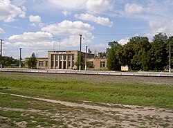 Railway station in Lutovynivka (Hannivka) | |
 Coat of arms | |
| 49°14′N 33°54′E / 49.233°N 33.900°E / 49.233; 33.900 | |
| Country Oblast Raion | Ukraine Poltava Oblast Kremenchuk Raion |
| Founded | 1923 |
| Area | |
| • Total | 1 km2 (0.4 sq mi) |
| Elevation | 158 m (518 ft) |
| Population | |
| • Total | 2,000 |
| • Density | 2,000/km2 (5,000/sq mi) |
| Time zone | UTC+2 (EET) |
| • Summer (DST) | UTC+3 (EET) |
| Postal code | 39100 |
| Area code | +380 5342 |
Lutovynivka (Ukrainian: Лутовинівка, Russian: Лутовиновка) is a small village, close to Kozelshchyna, in Kremenchuk Raion (district), Poltava Oblast (province) of central Ukraine, located 75 kilometres (47 mi) from Poltava. It belongs to Kozelshchyna settlement hromada, one of the hromadas of Ukraine.[1] The current estimated population is around 500 (as of 2012). Lutovynivka is also a railway station, and located close to the highway M22-E584.
Until 18 July 2020, Lutovynivka belonged to Kozelshchyna Raion. The raion was abolished in July 2020 as part of the administrative reform of Ukraine, which reduced the number of raions of Poltava Oblast to four. The area of Kozelshchyna Raion was merged into Kremenchuk Raion.[2][3]
References
- ^ "Козельщинская громада" (in Russian). Портал об'єднаних громад України.
- ^ "Про утворення та ліквідацію районів. Постанова Верховної Ради України № 807-ІХ". Голос України (in Ukrainian). 2020-07-18. Retrieved 2020-10-03.
- ^ "Нові райони: карти + склад" (in Ukrainian). Міністерство розвитку громад та територій України.
- v
- t
- e
Administrative divisions of Poltava Oblast
Administrative center: Poltava
- Kremenchuk
- Lubny
- Myrhorod
- Poltava
- Bilotserkivka
- Bilyky
- Chornukhy
- Chutove
- Drabynivka
- Dykanka
- Hadiach
- Hlobyne
- Hoholeve
- Horishni Plavni
- Hradyzk
- Hrebinka
- Kamiani Potoky
- Karlivka
- Khorol
- Kobeliaky
- Kolomatske
- Komyshnia
- Kotelva
- Kozelshchyna
- Krasna Luka
- Kremenchuk
- Lanna
- Liutenka
- Lokhvytsia
- Lubny
- Machukhy
- Martynivka
- Mashivka
- Mykhailivka
- Myrhorod
- Nekhvoroshcha
- Novo Haleshchyna
- Novi Sanzhary
- Novoorzhytske
- Novoselivka
- Obolon
- Omelnyk
- Opishnia
- Orzhytsia
- Petrivka-Romenska
- Pishchane
- Poltava
- Pryshyb
- Pyriatyn
- Reshetylivka
- Romodan
- Semenivka
- Sencha
- Serhiivka
- Shcherbani
- Shyshaky
- Skorokhodove
- Tereshky
- Velyka Bahachka
- Velyka Rublivka
- Velyki Budyshcha
- Velyki Sorochyntsi
- Zavodske
- Zinkiv


 Lutovynivka