Mendel Glacier
Glacier in California, United States
37°10′42″N 118°40′58″W / 37.17833°N 118.68278°W / 37.17833; -118.68278
Mendel Glacier is on the north side of Mount Mendel in the Sierra Nevada, California.[1] The name is commonly used; however, the name is not recognized by the United States Geological Survey in the Geographic Names Information System. Mendel Glacier is .35 miles (0.56 km) north of Darwin Glacier at 12,500 feet (3,800 m) above sea level.
The middle and lower portions of the glacier are covered with rock debris.
A US Army plane crashed above or into the glacier in 1942 with four airmen on board during a navigation training mission.[2]
-
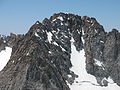 Upper Mendel Glacier July, 2006
 -
 Mendel Glacier Terminus July, 2006


See also
References
- v
- t
- e
 | This article about a glacier in the United States is a stub. You can help Wikipedia by expanding it. |
- v
- t
- e


