Moose Falls
Waterfall in Teton County, Wyoming
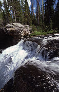
44°09′08″N 110°40′20″W / 44.15222°N 110.67222°W / 44.15222; -110.67222 (Moose Falls)[1]Moose Falls (height 30 feet (9.1 m)) is a plunge type waterfall on Crawfish Creek in Yellowstone National Park. The waterfall was named in 1885 by members of the Arnold Hague Geologic Survey for the plentiful moose found in the southern sections of the park.[2] The falls are just 75 yards (69 m) west of south entrance road via an easy trail that begins 1.2 miles (1.9 km) north of the south entrance station.
Climate
There is climate data for the nearby Snake River Station. Moose Falls has a subarctic climate (Köppen Dfc).
| Climate data for Snake River, Wyoming, 1991–2020 normals, 1905–2020 extremes: 6882ft (2098m) | |||||||||||||
|---|---|---|---|---|---|---|---|---|---|---|---|---|---|
| Month | Jan | Feb | Mar | Apr | May | Jun | Jul | Aug | Sep | Oct | Nov | Dec | Year |
| Record high °F (°C) | 51 (11) | 57 (14) | 62 (17) | 74 (23) | 83 (28) | 92 (33) | 97 (36) | 94 (34) | 90 (32) | 83 (28) | 64 (18) | 51 (11) | 97 (36) |
| Mean maximum °F (°C) | 38.9 (3.8) | 43.9 (6.6) | 53.4 (11.9) | 62.2 (16.8) | 72.5 (22.5) | 81.2 (27.3) | 86.6 (30.3) | 86.2 (30.1) | 81.0 (27.2) | 69.4 (20.8) | 51.9 (11.1) | 39.4 (4.1) | 87.7 (30.9) |
| Mean daily maximum °F (°C) | 26.0 (−3.3) | 30.1 (−1.1) | 38.8 (3.8) | 45.5 (7.5) | 56.4 (13.6) | 66.4 (19.1) | 76.9 (24.9) | 76.3 (24.6) | 66.0 (18.9) | 50.7 (10.4) | 35.3 (1.8) | 25.4 (−3.7) | 49.5 (9.7) |
| Daily mean °F (°C) | 13.3 (−10.4) | 16.4 (−8.7) | 24.9 (−3.9) | 32.9 (0.5) | 42.2 (5.7) | 50.3 (10.2) | 57.4 (14.1) | 55.7 (13.2) | 47.0 (8.3) | 35.8 (2.1) | 23.1 (−4.9) | 13.5 (−10.3) | 34.4 (1.3) |
| Mean daily minimum °F (°C) | 0.6 (−17.4) | 2.7 (−16.3) | 11.0 (−11.7) | 20.4 (−6.4) | 28.0 (−2.2) | 34.2 (1.2) | 37.9 (3.3) | 35.1 (1.7) | 28.0 (−2.2) | 20.8 (−6.2) | 10.8 (−11.8) | 1.6 (−16.9) | 19.3 (−7.1) |
| Mean minimum °F (°C) | −25.9 (−32.2) | −23.5 (−30.8) | −14.7 (−25.9) | 3.6 (−15.8) | 15.3 (−9.3) | 24.8 (−4.0) | 28.5 (−1.9) | 25.3 (−3.7) | 17.7 (−7.9) | 6.0 (−14.4) | −12.2 (−24.6) | −25.1 (−31.7) | −30.5 (−34.7) |
| Record low °F (°C) | −47 (−44) | −56 (−49) | −50 (−46) | −22 (−30) | 0 (−18) | 16 (−9) | 20 (−7) | 12 (−11) | 2 (−17) | −22 (−30) | −38 (−39) | −47 (−44) | −56 (−49) |
| Average precipitation inches (mm) | 3.88 (99) | 3.07 (78) | 3.02 (77) | 2.81 (71) | 2.78 (71) | 2.44 (62) | 1.41 (36) | 1.60 (41) | 1.87 (47) | 2.27 (58) | 3.46 (88) | 4.21 (107) | 32.82 (835) |
| Average snowfall inches (cm) | 65.00 (165.1) | 50.20 (127.5) | 31.00 (78.7) | 25.90 (65.8) | 5.00 (12.7) | 0.30 (0.76) | 0.00 (0.00) | 0.00 (0.00) | 0.20 (0.51) | 8.90 (22.6) | 42.40 (107.7) | 64.70 (164.3) | 293.6 (745.67) |
| Average extreme snow depth inches (cm) | 52.9 (134) | 60.9 (155) | 62.4 (158) | 50.5 (128) | 22.8 (58) | 0.9 (2.3) | 0.0 (0.0) | 0.0 (0.0) | 0.1 (0.25) | 5.7 (14) | 15.9 (40) | 39.1 (99) | 65.2 (166) |
| Average precipitation days (≥ 0.01 in) | 18.0 | 16.0 | 14.8 | 14.8 | 12.5 | 12.7 | 9.0 | 9.2 | 8.7 | 10.2 | 14.9 | 19.6 | 160.4 |
| Average snowy days (≥ 0.1 in) | 17.6 | 15.7 | 12.5 | 8.6 | 3.0 | 0.3 | 0.0 | 0.0 | 0.4 | 4.3 | 11.5 | 18.2 | 92.1 |
| Source 1: NOAA[3] | |||||||||||||
| Source 2: XMACIS2 (records, 1991-2020 monthly max/min & snow depth)[4] | |||||||||||||
Gallery
Images of Moose Falls
-
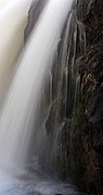 Close up of Moose Falls
 -
 Brink, 1977


See also
Notes
- ^ "Moose Falls". Geographic Names Information System. United States Geological Survey, United States Department of the Interior.
- ^ Whittlesey, Lee (1996). Yellowstone Place Names. Gardiner, MT: Wonderland Publishing Company. p. 174. ISBN 1-59971-716-6.
- ^ "Snake RVR, Wyoming 1991-2020 Monthly Normals". Retrieved October 14, 2023.
- ^ "xmACIS". National Oceanic and Atmospheric Administration. Retrieved February 19, 2024.
- v
- t
- e
Yellowstone National Park - Cascade Corner
Rivers, waterfalls, peaks and lakes in the Cascade Corner (Southwest) section of the park
- Bechler River
- Fall River
- Lewis River

- Bechler Falls
- Colonnade Falls
- Iris Falls
- Lewis Falls
- Moose Falls
- Terraced Falls
- Union Falls
- List of Yellowstone National Park related articles
 Media related to Waterfalls in Yellowstone at Wikimedia Commons

| Authority control databases: Geographic |
|
|---|


