Mutdapilly, Queensland
Map all coordinates using OpenStreetMap
Download coordinates as:
- KML
- GPX (all coordinates)
- GPX (primary coordinates)
- GPX (secondary coordinates)
Suburb of City of Ipswich, Queensland, Australia
27°45′55″S 152°38′32″E / 27.7652°S 152.6422°E / -27.7652; 152.6422 (Mutdapilly (locality))- 21.8 km (14 mi) SW of Ipswich
- 63.8 km (40 mi) NW of Beaudesert
- 60.7 km (38 mi) SW of Brisbane
- Scenic Rim Region
- City of Ipswich
- Wright
- Blair
| Suburbs around Mutdapilly: | ||
| Mount Forbes | Willowbank | Purga |
| Mount Forbes | Mutdapilly | Peak Crossing |
| Coleyville | Harrisville | Peak Crossing |
Mutdapilly is a rural locality in south-east Queensland, Australia. It is split between the local government areas of Scenic Rim Region and City of Ipswich.[2][3] In the 2021 census, Mutdapilly had a population of 308 people.[1]
Geography
Mutdapilly is centrally divided by the north/south running Cunningham Highway. The eastern boundary follows Warrill Creek.
There is one of fifteen air quality monitoring stations in the region located at Mutdapilly.[4]
History
The name Mutdapilly is believed to be a combination word from the Yuggera language (Yugarabul dialect) where mudtherri means sticky or muddy and pilly means gully.[3][2] The name was given by Captain Patrick Logan on 9 June 1827.[5]
Local farmer, Mr Denman, donated 2 acres of land to build a school. The Normanby State School and teacher's residence was opened on 27 April 1874; the first head teacher was John Stanfell Clowes who served at the school until 31 July 1876. The school was renamed Mutdapilly State School on 1 April 1968.[6][7][8]
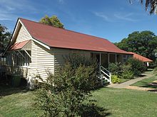
St Aidan's Church of England was built in Mutdapilly in 1921. It was a timber church building, designed by Charles Chauvel (the Australian filmmaker). It was dedicated on Easter Monday 15 April 1922 by Coadjutor Bishop Henry Le Fanu.[9] The church closed in 1974 and the building is now used as a residence.[8][10][11] It is at 3994 Cunningham Highway (27°46′11″S 152°39′01″E / 27.769692°S 152.6504°E / -27.769692; 152.6504 (St Aidan's Anglican Church)).[12]
Demographics
In the 2016 census, Mutdapilly had a population of 308 people.[13]
In the 2021 census, Mutdapilly had a population of 308 people.[1]
Education
Mutdapilly State School is a government primary (Prep-6) school for boys and girls at 4 Mutdapilly-Churchbank Weir Road (27°46′16″S 152°39′02″E / 27.7710°S 152.6506°E / -27.7710; 152.6506 (Mutdapilly State School)).[14][15] In 2018, the school had an enrolment of 29 students with 6 teachers (3 full-time equivalent) and 5 non-teaching staff (3 full-time equivalent).[16]
There are no secondary schools in Mutdapilly. The nearest secondary schools are Rosewood State High School in Rosewood to the north-west and Bremer State High School in Ipswich to the north-east.[17]
Heritage listings
Heritage listings for Mutdapilly include:
- 4 Mutdapilly-Churchbank Weir Road: Mutdapilly State School[18]
Notable residents
- Charles Chauvel, early Australian filmmaker
References
- ^ a b c Australian Bureau of Statistics (28 June 2022). "Mutdapilly (SAL)". 2021 Census QuickStats. Retrieved 28 February 2023.

- ^ a b "Mutdapilly (Scenic Rim Regional Council) (entry 45212)". Queensland Place Names. Queensland Government. Retrieved 27 February 2014.
- ^ a b "Mutdapilly (Ipswich City) (entry 46553)". Queensland Place Names. Queensland Government. Retrieved 27 February 2014.
- ^ "South East Queensland". Air monitoring network stations. The State of Queensland. 9 May 2014. Retrieved 16 April 2015.
- ^ "Indigenous Place Names" (PDF). Ipswich City Council. Retrieved 9 April 2015.
- ^ "Opening and closing dates of Queensland Schools". Queensland Government. Retrieved 18 April 2019.
- ^ "Agency ID 152, Mutdapilly State School". Queensland State Archives. Retrieved 27 February 2014.
- ^ a b "Harrisville & District" (PDF). Ipswich City Council. Archived from the original (PDF) on 6 April 2011. Retrieved 27 February 2014.
- ^ "MUTDAPILLY CHURCH DEDICATED". The Brisbane Courier. No. 20, 044. Queensland, Australia. 19 April 1922. p. 5. Retrieved 2 October 2022 – via National Library of Australia.
- ^ Starr, Joan (1988), Moreton Shire Queensland : discovery and settlement, Southern Cross PR and Press Services, ISBN 978-0-9588021-0-9
- ^ "Closed Anglican Churches". Anglican Church South Queensland. Archived from the original on 3 April 2019. Retrieved 29 June 2020.
- ^ Blake, Thom. "St Aidan's Anglican Church". Queensland religious places database. Retrieved 22 September 2022.
- ^ Australian Bureau of Statistics (27 June 2017). "Mutdapilly (SSC)". 2016 Census QuickStats. Retrieved 20 October 2018.
- ^ "State and non-state school details". Queensland Government. 9 July 2018. Archived from the original on 21 November 2018. Retrieved 21 November 2018.
- ^ "Mutdapilly State School". Retrieved 21 November 2018.
- ^ "ACARA School Profile 2018". Australian Curriculum, Assessment and Reporting Authority. Retrieved 28 January 2020.
- ^ "Queensland Globe". State of Queensland. Retrieved 19 January 2021.
- ^ "Mutdapilly State School (entry 602840)". Queensland Heritage Register. Queensland Heritage Council. Retrieved 17 December 2017.
Further reading
- Pohlner, Howard J (1980), St. John's Lutheran Church Engelsburg-Kalbar centenary book, including history of Mutdapilly Reserve, Teviotville, Aratula, Milbong, Centenary Committee, St. Johns Lutheran Church, ISBN 978-0-9598469-1-1
- Starr, Joan (1988), Moreton Shire Queensland : discovery and settlement, Southern Cross PR and Press Services, ISBN 978-0-9588021-0-9
External links
![]() Media related to Mutdapilly, Queensland at Wikimedia Commons}
Media related to Mutdapilly, Queensland at Wikimedia Commons}
- v
- t
- e
Suburbs in the City of Ipswich, South East Queensland
- Amberley
- Ashwell
- Augustine Heights
- Barellan Point
- Basin Pocket
- Bellbird Park
- Blacksoil
- Blackstone
- Booval
- Brassall
- Brookwater
- Bundamba
- Calvert
- Camira
- Carole Park
- Churchill
- Chuwar
- Coalfalls
- Collingwood Park
- Deebing Heights
- Dinmore
- East Ipswich
- Eastern Heights
- Ebenezer
- Ebbw Vale
- Flinders View
- Gailes
- Goodna
- Goolman
- Grandchester
- Haigslea
- Ipswich
- Ironbark
- Jeebropilly
- Karalee
- Karrabin
- Lanefield
- Leichhardt
- Limestone Ridges
- Lower Mount Walker
- Marburg
- Moores Pocket
- Mount Forbes
- Mount Marrow
- Mount Mort
- Mount Walker West
- Muirlea
- Mutdapilly
- New Chum
- Newtown
- North Booval
- North Ipswich
- North Tivoli
- One Mile
- Peak Crossing
- Pine Mountain
- Purga
- Raceview
- Redbank
- Redbank Plains
- Ripley
- Riverview
- Rosewood
- Sadliers Crossing
- Silkstone
- South Ripley
- Spring Mountain
- Springfield
- Springfield Central
- Springfield Lakes
- Swanbank
- Tallegalla
- Thagoona
- The Bluff
- Tivoli
- Walloon
- West Ipswich
- White Rock
- Willowbank
- Woodend
- Woolshed
- Wulkuraka
- Yamanto
Main Article: Local government areas of Queensland


