National Register of Historic Places listings in Anderson County, Texas

This is a list of the National Register of Historic Places listings in Anderson County, Texas.
This is intended to be a complete list of properties and districts listed on the National Register of Historic Places in Anderson County, Texas. There are five districts and 23 individual properties listed on the National Register in the county. Eight individually listed properties are designated Recorded Texas Historic Landmarks while more are contained within two districts.
This National Park Service list is complete through NPS recent listings posted May 31, 2024.[1]
Current listings
Map all coordinates using OpenStreetMap
Download coordinates as:
- KML
- GPX (all coordinates)
- GPX (primary coordinates)
- GPX (secondary coordinates)
The publicly disclosed locations of National Register properties and districts may be seen in a mapping service provided.[2]
| [3] | Name on the Register[4] | Image | Date listed[5] | Location | City or town | Description |
|---|---|---|---|---|---|---|
| 1 | Anderson Camp Ground |  | December 27, 1982 (#82001735) | W of Brushy Creek on Farm to Market Road 837 31°57′14″N 95°37′23″W / 31.953889°N 95.623056°W / 31.953889; -95.623056 (Anderson Camp Ground) | Brushy Creek | also called Brushy Creek Arbor and United Methodist Church |
| 2 | Anderson County Courthouse |  | September 28, 1992 (#92001256) | 1 Public Sq. 31°45′54″N 95°37′34″W / 31.765°N 95.626111°W / 31.765; -95.626111 (Anderson County Courthouse) | Palestine | Recorded Texas Historic Landmark |
| 3 | Anderson County Jail |  | June 11, 1998 (#98000692) | 704 Avenue A 31°45′50″N 95°37′36″W / 31.763889°N 95.626667°W / 31.763889; -95.626667 (Anderson County Jail) | Palestine | Historic and Architectural Resources of Palestine MPS |
| 4 | William and Caroline Broyles House | 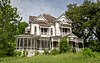 | November 10, 1988 (#88002614) | 1305 S. Sycamore St. 31°44′52″N 95°37′44″W / 31.747778°N 95.628889°W / 31.747778; -95.628889 (William and Caroline Broyles House) | Palestine | Recorded Texas Historic Landmark |
| 5 | Denby Building | 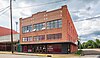 | June 11, 1998 (#98000694) | 201 W. Crawford St. 31°45′47″N 95°37′56″W / 31.763056°N 95.632222°W / 31.763056; -95.632222 (Denby Building) | Palestine | Historic and Architectural Resources of Palestine MPS |
| 6 | G. E. Dilley Building | 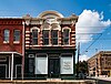 | June 11, 1998 (#98000698) | 503 W. Main St. 31°45′44″N 95°38′05″W / 31.762222°N 95.634722°W / 31.762222; -95.634722 (G. E. Dilley Building) | Palestine | Historic and Architectural Resources of Palestine MPS |
| 7 | First Presbyterian Church |  | June 11, 1998 (#98000695) | 406 Avenue A 31°45′45″N 95°37′44″W / 31.7625°N 95.628889°W / 31.7625; -95.628889 (First Presbyterian Church) | Palestine | Recorded Texas Historic Landmark; Historic and Architectural Resources of Palestine MPS |
| 8 | Freeman Farm | 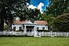 | June 12, 2000 (#00000656) | Co. Rd. 323, 3 miles SE of Frankston 31°59′38″N 95°29′53″W / 31.993889°N 95.498056°W / 31.993889; -95.498056 (Freeman Farm) | Frankston | also called Kickapoo Farm, Freeman Plantation |
| 9 | Gatewood-Shelton Gin | 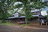 | June 3, 1998 (#98000637) | 304 E. Crawford 31°45′50″N 95°37′41″W / 31.763889°N 95.628056°W / 31.763889; -95.628056 (Gatewood-Shelton Gin) | Palestine | Historic and Architectural Resources of Palestine MPS |
| 10 | Howard House |  | March 14, 1993 (#93000072) | 1011 N. Perry St. 31°46′11″N 95°37′34″W / 31.769722°N 95.626111°W / 31.769722; -95.626111 (Howard House) | Palestine | Recorded Texas Historic Landmark; part of the North Side Historic District |
| 11 | Lincoln High School | Upload image | June 3, 1998 (#98000636) | 920 W. Swantz St. 31°45′20″N 95°38′26″W / 31.755556°N 95.640556°W / 31.755556; -95.640556 (Lincoln High School) | Palestine | Historic and Architectural Resources of Palestine MPS; burned in 1999, demolished. |
| 12 | Link House | 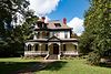 | May 29, 1980 (#80004073) | 925 N. Link St. 31°46′06″N 95°37′46″W / 31.76847°N 95.6294°W / 31.76847; -95.6294 (Link House) | Palestine | Part of the North Side Historic District; also called Link-Bunton House |
| 13 | Michaux Park Historic District |  | April 28, 2004 (#04000380) | Roughly bounded by S. Micheaux St., Jolly St., Crokett Rd., Rogers St., and E Park Ave. 31°45′16″N 95°37′32″W / 31.7545°N 95.6256°W / 31.7545; -95.6256 (Michaux Park Historic District) | Palestine | Historic and Architectural Resources of Palestine MPS |
| 14 | Mount Vernon African Methodist Episcopal Church | 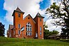 | June 3, 1998 (#98000635) | 913 E. Calhoun St. 31°46′05″N 95°37′22″W / 31.768056°N 95.622778°W / 31.768056; -95.622778 (Mount Vernon African Methodist Episcopal Church) | Palestine | Recorded Texas Historic Landmark; Historic and Architectural Resources of Palestine MPS |
| 15 | North Side Historic District | 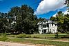 | July 1, 1998 (#98000825) | Roughly bounded by Kolsted, N. Perry, W. Green, and N. Conrad Sts. 31°46′07″N 95°37′53″W / 31.768611°N 95.631389°W / 31.768611; -95.631389 (North Side Historic District) | Palestine | Includes Recorded Texas Historic Landmarks; Historic and Architectural Resources of Palestine MPS |
| 16 | Old Town Residential Historic District |  | June 15, 2006 (#06000509) | Roughly surrounded by Lacey St. 31°46′02″N 95°37′22″W / 31.767222°N 95.622778°W / 31.767222; -95.622778 (Old Town Residential Historic District) | Palestine | |
| 17 | Pace McDonald Site |  | August 12, 1982 (#82004488) | Address restricted[6] | Palestine | Smithsonian trinomial 41AN51 |
| 18 | Palestine Carnegie Library |  | October 17, 1988 (#88001944) | 502 N. Queen St. 31°45′48″N 95°38′04″W / 31.763333°N 95.634444°W / 31.763333; -95.634444 (Palestine Carnegie Library) | Palestine | Recorded Texas Historic Landmark |
| 19 | Palestine High School |  | September 24, 1986 (#86002295) | 400 Micheaux Ave. 31°45′29″N 95°37′38″W / 31.758056°N 95.627222°W / 31.758056; -95.627222 (Palestine High School) | Palestine | Recorded Texas Historic Landmark; currently the Museum for East Texas Culture |
| 20 | Palestine New Town Commercial Historic District |  | October 6, 2021 (#100007058) | Roughly bounded by North Queen, Crawford, North Houston, and Spring Sts. 31°45′44″N 95°37′57″W / 31.7622°N 95.6325°W / 31.7622; -95.6325 (Palestine New Town Commercial Historic District) | Palestine | |
| 21 | Post Office-Palestine |  | June 11, 1998 (#98000693) | 101 E. Oak St. 31°45′46″N 95°37′52″W / 31.76281°N 95.63120°W / 31.76281; -95.63120 (Post Office-Palestine) | Palestine | Historic and Architectural Resources of Palestine MPS |
| 22 | John H Reagan Monument | 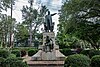 | June 3, 1998 (#98000633) | Reagan Park; vicinity of Park and Crockett Sts. 31°45′28″N 95°37′31″W / 31.75781°N 95.62530°W / 31.75781; -95.62530 (John H Reagan Monument) | Palestine | Historic and Architectural Resources of Palestine MPS |
| 23 | Redlands Hotel |  | June 3, 1998 (#98000634) | 400 N. Queen St. 31°45′46″N 95°38′04″W / 31.76287°N 95.63436°W / 31.76287; -95.63436 (Redlands Hotel) | Palestine | Historic and Architectural Resources of Palestine MPS |
| 24 | Robinson Bank Building | 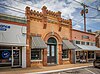 | June 11, 1998 (#98000691) | 213 W. Main St. 31°45′44″N 95°37′58″W / 31.762222°N 95.632778°W / 31.762222; -95.632778 (Robinson Bank Building) | Palestine | Historic and Architectural Resources of Palestine MPS |
| 25 | Sacred Heart Catholic Church and School | 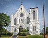 | December 6, 1979 (#79002909) | 503 N. Queen St. 31°45′45″N 95°38′04″W / 31.7625°N 95.634444°W / 31.7625; -95.634444 (Sacred Heart Catholic Church and School) | Palestine | Recorded Texas Historic Landmark |
| 26 | A. C. Saunders Site | | July 15, 1982 (#82004487) | Address restricted[6] | Frankston | Smithsonian trinomial 41AN19 |
| 27 | South Side Historic District | 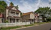 | July 1, 1998 (#98000826) | Roughly bounded by W. Colorado, and S. Michaux Sts., and Union Pacific Railroad Tracks 31°45′21″N 95°37′50″W / 31.755833°N 95.630556°W / 31.755833; -95.630556 (South Side Historic District) | Palestine | Includes Recorded Texas Historic Landmarks; Historic and Architectural Resources of Palestine MPS |
| 28 | Texas & Pacific Steam Locomotive No. 610 |  | March 25, 1977 (#77001477) | Park Road 70 31°44′28″N 95°34′16″W / 31.74118°N 95.5712°W / 31.74118; -95.5712 (Texas & Pacific Steam Locomotive No. 610) | Palestine |
See also
 National Register of Historic Places portal
 Texas portal


- National Register of Historic Places listings in Texas
- Recorded Texas Historic Landmarks in Anderson County
References
- ^ National Park Service, United States Department of the Interior, "National Register of Historic Places: Weekly List Actions", retrieved May 31, 2024.
- ^ The latitude and longitude information provided in this table was derived originally from the National Register Information System, which has been found to be fairly accurate for about 99% of listings. Some locations in this table may have been corrected to current GPS standards.
- ^ Numbers represent an alphabetical ordering by significant words. Various colorings, defined here, differentiate National Historic Landmarks and historic districts from other NRHP buildings, structures, sites or objects.
- ^ "National Register Information System". National Register of Historic Places. National Park Service. November 2, 2013.
- ^ The eight-digit number below each date is the number assigned to each location in the National Register Information System database, which can be viewed by clicking the number.
- ^ a b Federal and state laws and practices restrict general public access to information regarding the specific location of this resource. In some cases, this is to protect archeological sites from vandalism, while in other cases it is restricted at the request of the owner. See: Knoerl, John; Miller, Diane; Shrimpton, Rebecca H. (1990), Guidelines for Restricting Information about Historic and Prehistoric Resources, National Register Bulletin, National Park Service, U.S. Department of the Interior, OCLC 20706997.
External links
![]() Media related to National Register of Historic Places in Anderson County, Texas at Wikimedia Commons
Media related to National Register of Historic Places in Anderson County, Texas at Wikimedia Commons
Places adjacent to National Register of Historic Places listings in Anderson County, Texas | ||||||||||||||||
|---|---|---|---|---|---|---|---|---|---|---|---|---|---|---|---|---|
| ||||||||||||||||


- v
- t
- e
by county
- Anderson
- Andrews
- Angelina
- Aransas
- Archer
- Armstrong
- Atascosa
- Austin
- Bailey
- Bandera
- Bastrop
- Baylor
- Bee
- Bell
- Bexar
- Blanco
- Borden
- Bosque
- Bowie
- Brazoria
- Brazos
- Brewster
- Briscoe
- Brooks
- Brown
- Burleson
- Burnet
- Caldwell
- Calhoun
- Callahan
- Cameron
- Camp
- Carson
- Cass
- Castro
- Chambers
- Cherokee
- Childress
- Clay
- Cochran
- Coke
- Coleman
- Collin
- Collingsworth
- Colorado
- Comal
- Comanche
- Concho
- Cooke
- Coryell
- Cottle
- Crane
- Crockett
- Crosby
- Culberson
- Dallam
- Dallas
- Dawson
- Deaf Smith
- Delta
- Denton
- DeWitt
- Dickens
- Dimmit
- Donley
- Duval
- Eastland
- Ector
- Edwards
- El Paso
- Ellis
- Erath
- Falls
- Fannin
- Fayette
- Fisher
- Floyd
- Foard
- Fort Bend
- Franklin
- Freestone
- Frio
- Gaines
- Galveston
- Garza
- Gillespie
- Glasscock
- Goliad
- Gonzales
- Gray
- Grayson
- Gregg
- Grimes
- Guadalupe
- Hale
- Hall
- Hamilton
- Hansford
- Hardeman
- Hardin
- Harris
- Harrison
- Hartley
- Haskell
- Hays
- Hemphill
- Henderson
- Hidalgo
- Hill
- Hockley
- Hood
- Hopkins
- Houston
- Howard
- Hudspeth
- Hunt
- Hutchinson
- Irion
- Jack
- Jackson
- Jasper
- Jeff Davis
- Jefferson
- Jim Hogg
- Jim Wells
- Johnson
- Jones
- Karnes
- Kaufman
- Kendall
- Kenedy
- Kent
- Kerr
- Kimble
- King
- Kinney
- Kleberg
- Knox
- La Salle
- Lamar
- Lamb
- Lampasas
- Lavaca
- Lee
- Leon
- Liberty
- Limestone
- Lipscomb
- Live Oak
- Llano
- Loving
- Lubbock
- Lynn
- Madison
- Marion
- Martin
- Mason
- Matagorda
- Maverick
- McCulloch
- McLennan
- McMullen
- Medina
- Menard
- Midland
- Milam
- Mills
- Mitchell
- Montague
- Montgomery
- Moore
- Morris
- Motley
- Nacogdoches
- Navarro
- Newton
- Nolan
- Nueces
- Ochiltree
- Oldham
- Orange
- Palo Pinto
- Panola
- Parker
- Parmer
- Pecos
- Polk
- Potter
- Presidio
- Rains
- Randall
- Reagan
- Real
- Red River
- Reeves
- Refugio
- Roberts
- Robertson
- Rockwall
- Runnels
- Rusk
- Sabine
- San Augustine
- San Jacinto
- San Patricio
- San Saba
- Schleicher
- Scurry
- Shackelford
- Shelby
- Sherman
- Smith
- Somervell
- Starr
- Stephens
- Sterling
- Stonewall
- Sutton
- Swisher
- Tarrant
- Taylor
- Terrell
- Terry
- Throckmorton
- Titus
- Tom Green
- Travis
- Trinity
- Tyler
- Upshur
- Upton
- Uvalde
- Val Verde
- Van Zandt
- Victoria
- Walker
- Waller
- Ward
- Washington
- Webb
- Wharton
- Wheeler
- Wichita
- Wilbarger
- Willacy
- Williamson
- Wilson
- Winkler
- Wise
- Wood
- Yoakum
- Young
- Zapata
- Zavala

Municipalities and communities of Anderson County, Texas, United States | ||
|---|---|---|
County seat: Palestine | ||
| City |  | |
| Towns | ||
| CDP | ||
| Other communities | ||
| Ghost towns | ||
| Footnote | ‡This populated place also has portions in an adjacent county or counties | |
| ||


