National Register of Historic Places listings in Carter County, Missouri
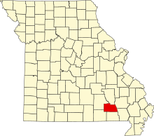
This is a list of the National Register of Historic Places listings in Carter County, Missouri.
This is intended to be a complete list of the properties and districts on the National Register of Historic Places in Carter County, Missouri, United States. Latitude and longitude coordinates are provided for many National Register properties and districts; these locations may be seen together in a map.[1]
There are 31 properties and districts listed on the National Register in the county.
This National Park Service list is complete through NPS recent listings posted June 7, 2024.[2]
Map all coordinates using OpenStreetMap
Download coordinates as:
- KML
- GPX (all coordinates)
- GPX (primary coordinates)
- GPX (secondary coordinates)
Current listings
| [3] | Name on the Register | Image | Date listed[4] | Location | City or town | Description |
|---|---|---|---|---|---|---|
| 1 | Mrs. Louis Bedell House |  | October 14, 1980 (#80002324) | 3rd and Maple Sts. 36°49′55″N 90°49′15″W / 36.831944°N 90.820833°W / 36.831944; -90.820833 (Mrs. Louis Bedell House) | Grandin | |
| 2 | Big Spring Historic District |  | March 17, 1981 (#81000101) | E of Van Buren on MO 103 36°56′55″N 90°59′35″W / 36.948611°N 90.993056°W / 36.948611; -90.993056 (Big Spring Historic District) | Van Buren | |
| 3 | Earl Boyer House | Upload image | October 14, 1980 (#80002325) | 5th St. 36°49′42″N 90°49′18″W / 36.828333°N 90.821667°W / 36.828333; -90.821667 (Earl Boyer House) | Grandin | |
| 4 | Carter County Courthouse |  | October 6, 2022 (#100008239) | 105 Main St. 36°59′42″N 91°00′52″W / 36.9951°N 91.0145°W / 36.9951; -91.0145 (Carter County Courthouse) | Van Buren | |
| 5 | Chubb Hollow Site | Upload image | January 18, 1990 (#89002272) | Address Restricted | Van Buren | |
| 6 | J. W. Gibson House | Upload image | October 14, 1980 (#80002326) | 6th and Pine Sts. 36°49′51″N 90°49′45″W / 36.830833°N 90.829167°W / 36.830833; -90.829167 (J. W. Gibson House) | Grandin | |
| 7 | Gooseneck Site | Upload image | October 2, 1990 (#90001473) | Hawes Memorial Campground: E½ SE¼ SW¼ of Section 15, Township 25 North, Range 1 East[5] 36°49′20″N 90°56′48″W / 36.822222°N 90.946667°W / 36.822222; -90.946667 (Gooseneck Site) | Poplar Bluff | |
| 8 | Delia Greensfelder House | Upload image | October 14, 1980 (#80002327) | 4th and N. Cherry Sts. 36°49′48″N 90°49′21″W / 36.83°N 90.8225°W / 36.83; -90.8225 (Delia Greensfelder House) | Grandin | |
| 9 | Loretta Herrington House | Upload image | October 14, 1980 (#80002328) | 5th St. 36°49′44″N 90°49′21″W / 36.828889°N 90.8225°W / 36.828889; -90.8225 (Loretta Herrington House) | Grandin | |
| 10 | James Hinton House | Upload image | October 14, 1980 (#80002329) | Walnut St. 36°50′00″N 90°49′11″W / 36.833333°N 90.819722°W / 36.833333; -90.819722 (James Hinton House) | Grandin | |
| 11 | Nettie Jacobson House | Upload image | October 14, 1980 (#80002330) | 6th and Oak Sts. 36°49′49″N 90°49′38″W / 36.830278°N 90.827222°W / 36.830278; -90.827222 (Nettie Jacobson House) | Grandin | |
| 12 | Isaac Kelley Site (23CT111 and 23CT1) | Upload image | February 4, 1988 (#87002531) | Address Restricted | Hunter | |
| 13 | Nola Kitterman House | Upload image | October 14, 1980 (#80002331) | 6th St. 36°49′54″N 90°49′53″W / 36.831667°N 90.831389°W / 36.831667; -90.831389 (Nola Kitterman House) | Grandin | |
| 14 | Wallace Knapp House | Upload image | October 14, 1980 (#80002332) | 6th and S. Elm Sts. 36°49′49″N 90°49′37″W / 36.830278°N 90.826944°W / 36.830278; -90.826944 (Wallace Knapp House) | Grandin | |
| 15 | Buford Lawhorn House | Upload image | October 14, 1980 (#80002333) | 6th St. 36°49′52″N 90°49′44″W / 36.831111°N 90.828889°W / 36.831111; -90.828889 (Buford Lawhorn House) | Grandin | |
| 16 | Iva Lewis House | Upload image | October 14, 1980 (#80002334) | 6th St. 36°49′49″N 90°49′41″W / 36.830278°N 90.828056°W / 36.830278; -90.828056 (Iva Lewis House) | Grandin | |
| 17 | Masonic Lodge | 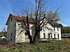 | October 14, 1980 (#80002335) | 5th and S. Elm Sts. 36°49′49″N 90°49′33″W / 36.830278°N 90.825833°W / 36.830278; -90.825833 (Masonic Lodge) | Grandin | |
| 18 | Terry Mays House | Upload image | October 14, 1980 (#80002336) | 6th and S. Plum St. 36°49′44″N 90°49′26″W / 36.828889°N 90.823889°W / 36.828889; -90.823889 (Terry Mays House) | Grandin | |
| 19 | Thornton McNew House | Upload image | October 14, 1980 (#80002337) | 6th and Spruce Sts. 36°49′53″N 90°49′47″W / 36.831389°N 90.829722°W / 36.831389; -90.829722 (Thornton McNew House) | Grandin | |
| 20 | Mill Pond | Upload image | October 14, 1980 (#80002338) | Off MO 21 36°49′53″N 90°48′46″W / 36.831389°N 90.812778°W / 36.831389; -90.812778 (Mill Pond) | Grandin | |
| 21 | Della Nance House | Upload image | October 14, 1980 (#80002339) | 6th St. 36°49′50″N 90°49′41″W / 36.830556°N 90.828056°W / 36.830556; -90.828056 (Della Nance House) | Grandin | |
| 22 | Hazel Owens House | 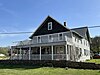 | October 14, 1980 (#80002340) | 5th St. 36°49′52″N 90°49′39″W / 36.831111°N 90.8275°W / 36.831111; -90.8275 (Hazel Owens House) | Grandin | |
| 23 | Phillips Bay Mill (23CT235) | Upload image | February 3, 1988 (#87002536) | Along a small Current River tributary southeast of Eastwood 36°51′02″N 90°57′45″W / 36.850556°N 90.962500°W / 36.850556; -90.962500 (Phillips Bay Mill (23CT235)) | Eastwood | |
| 24 | Ernie Phillips House | Upload image | October 14, 1980 (#80002341) | 3rd and N. Cherry Sts. 36°49′53″N 90°49′20″W / 36.831389°N 90.822222°W / 36.831389; -90.822222 (Ernie Phillips House) | Grandin | |
| 25 | Alvis Powers House | Upload image | October 14, 1980 (#80002342) | Walnut St. 36°49′56″N 90°49′13″W / 36.832222°N 90.820278°W / 36.832222; -90.820278 (Alvis Powers House) | Grandin | |
| 26 | Hazel Shoat House |  | October 14, 1980 (#80002343) | 5th St. 36°49′51″N 90°49′37″W / 36.830833°N 90.826944°W / 36.830833; -90.826944 (Hazel Shoat House) | Grandin | |
| 27 | Sixth Street Historic District |  | October 14, 1980 (#80002344) | 6th St. 36°49′46″N 90°49′36″W / 36.829444°N 90.826667°W / 36.829444; -90.826667 (Sixth Street Historic District) | Grandin | |
| 28 | James Smith House | Upload image | October 14, 1980 (#80002345) | 6th St. 36°49′43″N 90°49′24″W / 36.828611°N 90.823333°W / 36.828611; -90.823333 (James Smith House) | Grandin | |
| 29 | Lawrence Smith House |  | October 14, 1980 (#80002346) | 3rd St. 36°49′54″N 90°49′10″W / 36.831667°N 90.819444°W / 36.831667; -90.819444 (Lawrence Smith House) | Grandin | |
| 30 | William F. Smith House |  | October 14, 1980 (#80002347) | 6th St. 36°49′43″N 90°49′31″W / 36.828611°N 90.825278°W / 36.828611; -90.825278 (William F. Smith House) | Grandin | |
| 31 | Lee Tucker House | Upload image | October 14, 1980 (#80002348) | 3rd St. 36°49′56″N 90°49′30″W / 36.832222°N 90.825°W / 36.832222; -90.825 (Lee Tucker House) | Grandin |
See also
- List of National Historic Landmarks in Missouri
- National Register of Historic Places listings in Missouri
References
Wikimedia Commons has media related to National Register of Historic Places in Carter County, Missouri.
- ^ The latitude and longitude information provided in this table was derived originally from the National Register Information System, which has been found to be fairly accurate for about 99% of listings. Some locations in this table may have been corrected to current GPS standards.
- ^ National Park Service, United States Department of the Interior, "National Register of Historic Places: Weekly List Actions", retrieved June 7, 2024.
- ^ Numbers represent an alphabetical ordering by significant words. Various colorings, defined here, differentiate National Historic Landmarks and historic districts from other NRHP buildings, structures, sites or objects.
- ^ The eight-digit number below each date is the number assigned to each location in the National Register Information System database, which can be viewed by clicking the number.
- ^ Huber, James K., and George Rapp, Jr. "The Palynology of Two Archaeological Sites in the Southeast Missouri Ozarks". Plains Anthropologist 34.126 (1989): 293-308: 295.
- v
- t
- e
- List of U.S. National Historic Landmarks by state:
- Alabama
- Alaska
- Arizona
- Arkansas
- California
- Colorado
- Connecticut
- Delaware
- Florida
- Georgia
- Hawaii
- Idaho
- Illinois
- Indiana
- Iowa
- Kansas
- Kentucky
- Louisiana
- Maine
- Maryland
- Massachusetts
- Michigan
- Minnesota
- Mississippi
- Missouri
- Montana
- Nebraska
- Nevada
- New Hampshire
- New Jersey
- New Mexico
- New York
- North Carolina
- North Dakota
- Ohio
- Oklahoma
- Oregon
- Pennsylvania
- Rhode Island
- South Carolina
- South Dakota
- Tennessee
- Texas
- Utah
- Vermont
- Virginia
- Washington
- West Virginia
- Wisconsin
- Wyoming
 National Register of Historic Places portal
 Category


Municipalities and communities of Carter County, Missouri, United States | ||
|---|---|---|
County seat: Van Buren | ||
| Cities |  | |
| Townships | ||
| CDPs | ||
| Other communities | ||
| Ghost towns | ||
| ||


