National Register of Historic Places listings in El Paso County, Colorado
List of National Register of Historic Places in El Paso County, Colorado, United States

This is a list of the National Register of Historic Places listings in El Paso County, Colorado.
This is intended to be a complete list of the properties and districts on the National Register of Historic Places in El Paso County, Colorado, United States. The locations of National Register properties and districts for which the latitude and longitude coordinates are included below, may be seen in a map.[1]
There are 93 properties and districts listed on the National Register in the county, including 2 National Historic Landmarks. Another property was once listed but has been removed.
This National Park Service list is complete through NPS recent listings posted August 30, 2024.[2]
- v
- t
- e
Properties on the National Register of Historic Places in Colorado by county
- Adams
- Alamosa
- Arapahoe
- Archuleta
- Baca
- Bent
- Boulder
- Broomfield
- Chaffee
- Cheyenne
- Clear Creek
- Conejos
- Costilla
- Crowley
- Custer
- Delta
- Denver
- Dolores
- Douglas
- Eagle
- El Paso
- Elbert
- Fremont
- Garfield
- Gilpin
- Grand
- Gunnison
- Hinsdale
- Huerfano
- Jackson
- Jefferson
- Kiowa
- Kit Carson
- La Plata
- Lake
- Larimer
- Las Animas
- Lincoln
- Logan
- Mesa
- Mineral
- Moffat
- Montezuma
- Montrose
- Morgan
- Otero
- Ouray
- Park
- Phillips
- Pitkin
- Prowers
- Pueblo
- Rio Blanco
- Rio Grande
- Routt
- Saguache
- San Juan
- San Miguel
- Sedgwick
- Summit
- Teller
- Washington
- Weld
- Yuma

Map all coordinates using OpenStreetMap
Download coordinates as:
- KML
- GPX (all coordinates)
- GPX (primary coordinates)
- GPX (secondary coordinates)
Current listings
| [3] | Name on the Register[4] | Image | Date listed[5] | Location | City or town | Description |
|---|---|---|---|---|---|---|
| 1 | Alamo Hotel |  | September 14, 1977 (#77000373) | 128 S. Tejon St. 38°49′53″N 104°49′24″W / 38.831389°N 104.823333°W / 38.831389; -104.823333 (Alamo Hotel) | Colorado Springs | |
| 2 | Atchison, Topeka and Santa Fe Passenger Depot | 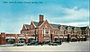 | September 10, 1979 (#79000597) | 555 E. Pikes Peak Ave. 38°49′58″N 104°48′49″W / 38.832778°N 104.813611°W / 38.832778; -104.813611 (Atchison, Topeka and Santa Fe Passenger Depot) | Colorado Springs | Designed by architect E. A. Harrison.[6] |
| 3 | Barker House |  | October 11, 1979 (#79000604) | 819 Manitou 38°51′28″N 104°55′00″W / 38.857778°N 104.916667°W / 38.857778; -104.916667 (Barker House) | Manitou Springs | |
| 4 | Bemis Hall |  | March 28, 1997 (#97000273) | 920 N. Cascade Ave. 38°50′54″N 104°49′34″W / 38.848333°N 104.826111°W / 38.848333; -104.826111 (Bemis Hall) | Colorado Springs | |
| 5 | Judson Moss Bemis House | 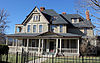 | September 14, 1979 (#79000598) | 506 N. Cascade Ave. 38°50′28″N 104°49′28″W / 38.841111°N 104.824444°W / 38.841111; -104.824444 (Judson Moss Bemis House) | Colorado Springs | |
| 6 | Black Forest School |  | November 3, 1992 (#92001407) | 6770 Shoup Rd. 39°00′47″N 104°42′02″W / 39.013056°N 104.700556°W / 39.013056; -104.700556 (Black Forest School) | Colorado Springs | |
| 7 | Black Squirrel Creek Bridge |  | October 15, 2002 (#02001158) | U.S. Highway 24 at milepost 327.33 39°00′12″N 104°30′46″W / 39.003333°N 104.512778°W / 39.003333; -104.512778 (Black Squirrel Creek Bridge) | Falcon | Demolished and replaced in 2012.[7] |
| 8 | Boulder Crescent Place Historic District |  | September 10, 1987 (#87001555) | 9 and 11 W. Boulder St. and 312, 318, and 320 N. Cascade 38°50′22″N 104°49′30″W / 38.839444°N 104.825°W / 38.839444; -104.825 (Boulder Crescent Place Historic District) | Colorado Springs | |
| 9 | Briarhurst |  | April 23, 1973 (#73000473) | 404 Manitou Ave. 38°51′14″N 104°54′12″W / 38.853889°N 104.903333°W / 38.853889; -104.903333 (Briarhurst) | Manitou Springs | |
| 10 | Bridge over Fountain Creek | 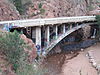 | February 4, 1985 (#85000206) | U.S. Highway 24 38°52′12″N 104°55′30″W / 38.87°N 104.925°W / 38.87; -104.925 (Bridge over Fountain Creek) | Manitou Springs | |
| 11 | Burgess House |  | September 13, 1990 (#90001418) | 730 N. Nevada Ave. 38°50′41″N 104°49′16″W / 38.844722°N 104.821111°W / 38.844722; -104.821111 (Burgess House) | Colorado Springs | |
| 12 | Calhan Paint Mines Archeological District |  | July 14, 2000 (#00000783) | Approximately 0.5 miles (0.80 km) southeast of the junction of S. Calhan Rd. and Paint Mine Rd. 39°01′07″N 104°16′04″W / 39.018611°N 104.267778°W / 39.018611; -104.267778 (Calhan Paint Mines Archeological District) | Calhan | |
| 13 | Calhan Rock Island Railroad Depot |  | April 20, 1995 (#95000476) | 252 feet west of Denver St. on Rock Island Railroad right-of-way 39°02′18″N 104°17′57″W / 39.038333°N 104.299167°W / 39.038333; -104.299167 (Calhan Rock Island Railroad Depot) | Calhan | |
| 14 | Carlton House | Upload image | November 3, 1989 (#89001785) | Pine Valley 38°57′58″N 104°51′02″W / 38.966111°N 104.850556°W / 38.966111; -104.850556 (Carlton House) | United States Air Force Academy | |
| 15 | Chadbourn Spanish Gospel Mission | 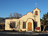 | January 14, 2009 (#08001316) | 402 S. Conejos St. 38°49′42″N 104°49′54″W / 38.828291°N 104.831632°W / 38.828291; -104.831632 (Chadbourn Spanish Gospel Mission) | Colorado Springs | |
| 16 | Chambers Ranch |  | November 29, 1979 (#79000599) | 3202 Chambers Way 38°52′21″N 104°52′20″W / 38.8725°N 104.872222°W / 38.8725; -104.872222 (Chambers Ranch) | Colorado Springs | |
| 17 | City Hall of Colorado City |  | June 3, 1982 (#82002300) | 2902 W. Colorado Ave. 38°51′04″N 104°52′07″W / 38.851197°N 104.868478°W / 38.851197; -104.868478 (City Hall of Colorado City) | Colorado Springs | |
| 18 | Claremont |  | April 13, 1977 (#77000374) | 21 Broadmoor Ave. 38°47′26″N 104°50′24″W / 38.790556°N 104.84°W / 38.790556; -104.84 (Claremont) | Colorado Springs | |
| 19 | Cliff House | 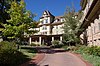 | March 27, 1980 (#80000897) | 306 Canon Ave. 38°51′35″N 104°55′00″W / 38.859722°N 104.916667°W / 38.859722; -104.916667 (Cliff House) | Manitou Springs | |
| 20 | Colorado Springs Airport |  | November 15, 1996 (#90001296) | Junction of Ent Ave. and Peterson Boulevard at Peterson Air Force Base 38°49′22″N 104°42′07″W / 38.822791°N 104.701895°W / 38.822791; -104.701895 (Colorado Springs Airport) | Colorado Springs | |
| 21 | Colorado Springs and Cripple Creek District Railway-Corley Mountain Highway |  | March 25, 1999 (#99000400) | Gold Camp Rd. and Forest Rd. 370 38°44′56″N 104°56′58″W / 38.748889°N 104.949444°W / 38.748889; -104.949444 (Colorado Springs and Cripple Creek District Railway-Corley Mountain Highway) | Colorado Springs | |
| 22 | Colorado Springs City Auditorium |  | November 7, 1995 (#95001244) | 231 E. Kiowa St. 38°50′06″N 104°49′11″W / 38.835°N 104.819722°W / 38.835; -104.819722 (Colorado Springs City Auditorium) | Colorado Springs | |
| 23 | Colorado Springs City Hall |  | February 19, 2002 (#02000075) | 107 N. Nevada Ave. 38°50′08″N 104°49′16″W / 38.835608°N 104.820997°W / 38.835608; -104.820997 (Colorado Springs City Hall) | Colorado Springs | |
| 24 | Colorado Springs Day Nursery |  | February 23, 1990 (#90000304) | 104 E. Rio Grande St. 38°49′28″N 104°49′25″W / 38.824578°N 104.823556°W / 38.824578; -104.823556 (Colorado Springs Day Nursery) | Colorado Springs | |
| 25 | Colorado Springs Fine Arts Center | 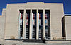 | July 3, 1986 (#86001455) | 30 W. Dale St. 38°50′45″N 104°49′32″W / 38.845833°N 104.825556°W / 38.845833; -104.825556 (Colorado Springs Fine Arts Center) | Colorado Springs | |
| 26 | Colorado Springs Public Library-Carnegie Building |  | November 1, 1996 (#96001238) | 21 W. Kiowa St. 38°50′08″N 104°49′35″W / 38.835659°N 104.826367°W / 38.835659; -104.826367 (Colorado Springs Public Library-Carnegie Building) | Colorado Springs | |
| 27 | Frederick H. Cossitt Memorial Hall |  | March 28, 1997 (#97000272) | 906 N. Cascade Ave. 38°50′51″N 104°49′34″W / 38.8475°N 104.826111°W / 38.8475; -104.826111 (Frederick H. Cossitt Memorial Hall) | Colorado Springs | |
| 28 | Cottonwood Creek Bridge |  | October 12, 2001 (#01001104) | On Vincent Dr. over Cottonwood Creek 38°55′43″N 104°48′35″W / 38.928611°N 104.809722°W / 38.928611; -104.809722 (Cottonwood Creek Bridge) | Colorado Springs | |
| 29 | Crystal Valley Cemetery |  | November 18, 1982 (#82001015) | Plainview Ave. 38°51′06″N 104°54′11″W / 38.851667°N 104.903056°W / 38.851667; -104.903056 (Crystal Valley Cemetery) | Manitou Springs | |
| 30 | Cutler Hall |  | July 3, 1986 (#86001410) | 912 N. Cascade Ave. 38°50′53″N 104°49′30″W / 38.848056°N 104.825°W / 38.848056; -104.825 (Cutler Hall) | Colorado Springs | |
| 31 | DeGraff Building | 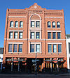 | August 18, 1983 (#83001293) | 116-118 N. Tejon 38°50′10″N 104°49′25″W / 38.836111°N 104.823611°W / 38.836111; -104.823611 (DeGraff Building) | Colorado Springs | |
| 32 | Dodge-Hamlin House |  | December 3, 2014 (#14000968) | 1148 N. Cascade Ave., 1122 Wood Ave. 38°51′00″N 104°49′36″W / 38.8501°N 104.8268°W / 38.8501; -104.8268 (Dodge-Hamlin House) | Colorado Springs | On the Colorado College campus. |
| 33 | Drennan School | 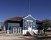 | April 16, 2008 (#08000290) | 20500 Drennan Rd. 38°45′07″N 104°26′49″W / 38.75181°N 104.44689°W / 38.75181; -104.44689 (Drennan School) | Colorado Springs | |
| 34 | Eastholme |  | October 22, 1998 (#98001250) | 4445 Haggerman Ave. 38°53′51″N 104°58′08″W / 38.8975°N 104.968889°W / 38.8975; -104.968889 (Eastholme) | Cascade | |
| 35 | Edgeplain |  | November 21, 2006 (#06001048) | 1106 N. Nevada Ave. 38°50′59″N 104°49′15″W / 38.849722°N 104.820833°W / 38.849722; -104.820833 (Edgeplain) | Colorado Springs | |
| 36 | El Paso County Courthouse |  | September 29, 1972 (#72000272) | 215 S. Tejon St. 38°49′48″N 104°49′20″W / 38.83°N 104.822222°W / 38.83; -104.822222 (El Paso County Courthouse) | Colorado Springs | |
| 37 | El Pomar Estate |  | November 22, 1995 (#95001328) | 1661 Mesa Ave. 38°47′18″N 104°51′28″W / 38.788333°N 104.857778°W / 38.788333; -104.857778 (El Pomar Estate) | Colorado Springs | |
| 38 | Emmanuel Presbyterian Church |  | May 17, 1984 (#84000830) | 419 Mesa Rd. 38°50′45″N 104°49′54″W / 38.845833°N 104.831667°W / 38.845833; -104.831667 (Emmanuel Presbyterian Church) | Colorado Springs | |
| 39 | J.G. Evans Barn | 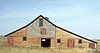 | June 22, 2004 (#04000624) | Hodgen Rd. 39°04′18″N 104°41′25″W / 39.071667°N 104.690278°W / 39.071667; -104.690278 (J.G. Evans Barn) | Black Forest | |
| 40 | Evergreen Cemetery |  | February 11, 1993 (#93000035) | 1005 S. Hancock Ave. 38°48′56″N 104°47′43″W / 38.815556°N 104.795278°W / 38.815556; -104.795278 (Evergreen Cemetery) | Colorado Springs | |
| 41 | First Congregational Church |  | October 31, 2002 (#02001258) | 20 E. St. Vrain St. 38°50′28″N 104°49′22″W / 38.841111°N 104.822778°W / 38.841111; -104.822778 (First Congregational Church) | Colorado Springs | |
| 42 | First Congregational Church | 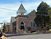 | October 16, 1979 (#79000606) | 101 Pawnee Ave. 38°51′23″N 104°54′47″W / 38.856389°N 104.913056°W / 38.856389; -104.913056 (First Congregational Church) | Manitou Springs | |
| 43 | First Presbyterian Church of Ramah |  | July 7, 1988 (#88001015) | 113 S. Commercial St. 39°07′13″N 104°10′02″W / 39.120278°N 104.167222°W / 39.120278; -104.167222 (First Presbyterian Church of Ramah) | Ramah | |
| 44 | Fort Collins Municipal Railway No. 22 |  | December 15, 2011 (#11000901) | 2333 Steel Dr. 38°52′01″N 104°49′53″W / 38.866828°N 104.831371°W / 38.866828; -104.831371 (Fort Collins Municipal Railway No. 22) | Colorado Springs | |
| 45 | Giddings Building |  | April 21, 1983 (#83001294) | 101 N. Tejon St. 38°50′08″N 104°50′03″W / 38.835556°N 104.834167°W / 38.835556; -104.834167 (Giddings Building) | Colorado Springs | |
| 46 | Glen Eyrie |  | April 21, 1975 (#75000519) | 3820 N. 30th St. 38°53′29″N 104°53′05″W / 38.891389°N 104.884722°W / 38.891389; -104.884722 (Glen Eyrie) | Colorado Springs | Boundary increase listed December 20, 2016. |
| 47 | Grace and St. Stephen's Episcopal Church |  | December 15, 2011 (#11000902) | 631 N. Tejon St. 38°50′34″N 104°49′23″W / 38.842858°N 104.823022°W / 38.842858; -104.823022 (Grace and St. Stephen's Episcopal Church) | Colorado Springs | |
| 48 | Gwynne-Love House |  | February 5, 1987 (#87000010) | 730 N. Cascade Ave. 38°50′42″N 104°49′29″W / 38.845°N 104.824722°W / 38.845; -104.824722 (Gwynne-Love House) | Colorado Springs | |
| 49 | Hagerman Mansion |  | September 20, 1984 (#84000831) | 610 N. Cascade Ave. 38°50′36″N 104°49′32″W / 38.843333°N 104.825556°W / 38.843333; -104.825556 (Hagerman Mansion) | Colorado Springs | |
| 50 | Keithley Log Cabin Development District |  | November 18, 1982 (#82001016) | Roughly bounded by Santa Fe Pl., Crystal Rd., and Spur Rd. 38°51′13″N 104°53′59″W / 38.853611°N 104.899722°W / 38.853611; -104.899722 (Keithley Log Cabin Development District) | Manitou Springs | |
| 51 | Lennox House |  | October 21, 1999 (#99001266) | 1001 N. Nevada Ave. 38°50′53″N 104°49′10″W / 38.848056°N 104.819444°W / 38.848056; -104.819444 (Lennox House) | Colorado Springs | |
| 52 | Inez Johnson Lewis School |  | November 3, 1988 (#88002306) | 146 Jefferson St. 39°05′28″N 104°52′13″W / 39.091111°N 104.870278°W / 39.091111; -104.870278 (Inez Johnson Lewis School) | Monument | |
| 53 | Lindley-Johnson-Vanderhoof House |  | December 3, 2013 (#13000870) | 1130 N. Cascade Ave. 38°51′01″N 104°49′30″W / 38.850203°N 104.825°W / 38.850203; -104.825 (Lindley-Johnson-Vanderhoof House) | Colorado Springs | |
| 54 | Little Fountain Creek Bridge | Upload image | October 15, 2002 (#02001153) | State Highway 115 at milepost 36.84 38°40′36″N 104°50′55″W / 38.676667°N 104.848611°W / 38.676667; -104.848611 (Little Fountain Creek Bridge) | Widefield | Replaced in 2004. |
| 55 | Manitou Bathhouse |  | August 1, 1979 (#79000608) | 934 Manitou Ave. 38°51′33″N 104°55′02″W / 38.859167°N 104.917222°W / 38.859167; -104.917222 (Manitou Bathhouse) | Manitou Springs | |
| 56 | Manitou Springs Bridges (2) |  | June 24, 1985 (#85001398) | Park Ave. and Cannon Ave. over Fountain Creek 38°51′30″N 104°54′57″W / 38.858333°N 104.915833°W / 38.858333; -104.915833 (Manitou Springs Bridges (2)) | Manitou Springs | |
| 57 | Manitou Springs Historic District |  | October 7, 1983 (#83003516) | Roughly bounded by El Paso Boulevard, Ruxton Ave., U.S. Highway 24, and Iron Mt. Ave. 38°51′28″N 104°55′14″W / 38.857778°N 104.920556°W / 38.857778; -104.920556 (Manitou Springs Historic District) | Manitou Springs | |
| 58 | Maytag Aircraft Building |  | January 16, 2008 (#07001393) | 701 S. Cascade Ave. 38°49′27″N 104°49′30″W / 38.824167°N 104.825°W / 38.824167; -104.825 (Maytag Aircraft Building) | Colorado Springs | |
| 59 | McAllister House |  | August 14, 1973 (#73000472) | 423 N. Cascade Ave. 38°50′21″N 104°49′26″W / 38.839167°N 104.823889°W / 38.839167; -104.823889 (McAllister House) | Colorado Springs | |
| 60 | McGregor Hall |  | January 27, 2000 (#99001705) | 930 N. Cascade Ave. 38°50′56″N 104°49′36″W / 38.848889°N 104.826667°W / 38.848889; -104.826667 (McGregor Hall) | Colorado Springs | |
| 61 | Midland Terminal Railroad Roundhouse |  | July 10, 1979 (#79000600) | 600 S. 21st St. 38°50′24″N 104°51′32″W / 38.84°N 104.858889°W / 38.84; -104.858889 (Midland Terminal Railroad Roundhouse) | Colorado Springs | |
| 62 | Miramont | 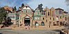 | April 11, 1977 (#77000375) | 9 Capitol Hill 38°51′33″N 104°55′19″W / 38.859167°N 104.921944°W / 38.859167; -104.921944 (Miramont) | Manitou Springs | |
| 63 | Montgomery Hall, Colorado College |  | September 13, 1990 (#90001419) | 1030 N. Cascade Ave. 38°50′56″N 104°49′33″W / 38.848889°N 104.825833°W / 38.848889; -104.825833 (Montgomery Hall, Colorado College) | Colorado Springs | |
| 64 | Monument Valley Park |  | January 25, 2007 (#06001287) | Approximately bounded by Monroe, Culebra, Westview, and Bijou Sts., the BNSF railway line, and the western edge of the main north/south trail, all north of Del Norte 38°51′11″N 104°49′48″W / 38.852943°N 104.830098°W / 38.852943; -104.830098 (Monument Valley Park) | Colorado Springs | |
| 65 | Navajo Hogan |  | September 13, 1990 (#90001420) | 2817 N. Nevada Ave. 38°52′20″N 104°49′08″W / 38.872222°N 104.818889°W / 38.872222; -104.818889 (Navajo Hogan) | Colorado Springs | |
| 66 | North Cheyenne Canon Park |  | July 8, 2009 (#09000489) | 2120 N. Cheyenne Cañon Rd. 38°47′26″N 104°52′26″W / 38.790503°N 104.873822°W / 38.790503; -104.873822 (North Cheyenne Canon Park) | Colorado Springs | |
| 67 | North Weber Street-Wahsatch Avenue Historic Residential District |  | February 8, 1985 (#85000205) | N. Weber St. between Boulder and Del Norte St., and N. Wahsatch Ave. between St. Vrain and Columbia St. 38°50′53″N 104°49′04″W / 38.848056°N 104.817778°W / 38.848056; -104.817778 (North Weber Street-Wahsatch Avenue Historic Residential District) | Colorado Springs | |
| 68 | Old Colorado City Historic Commercial District |  | November 2, 1982 (#82001018) | Northern side of Colorado Ave. from 24th St., west to 2611 Colorado Ave., also includes 115 S. 26 St. and 2418 W. Pikes Peak Ave. 38°50′50″N 104°51′46″W / 38.847222°N 104.862778°W / 38.847222; -104.862778 (Old Colorado City Historic Commercial District) | Colorado Springs | |
| 69 | Old Livery Stable |  | March 2, 1979 (#79000603) | 217 W. Missouri 38°40′57″N 104°42′08″W / 38.6825°N 104.702222°W / 38.6825; -104.702222 (Old Livery Stable) | Fountain | |
| 70 | Old North End Historic District |  | December 17, 1982 (#82001017) | Roughly bounded by Monument Valley Wood, Nevada Ave., and Madison and Unitah Sts.; also bounded by Monument Valley Park, the alley between Nevada Ave. and Weber St., and Lilac and Uintah Sts. 38°51′27″N 104°49′21″W / 38.8575°N 104.8225°W / 38.8575; -104.8225 (Old North End Historic District) | Colorado Springs | Second set of addresses represent a boundary increase of September 14, 2015, which changed the name from "North End Historic District". |
| 71 | Palmer Hall |  | July 3, 1986 (#86001412) | 116 E. San Rafael 38°50′56″N 104°49′19″W / 38.848889°N 104.821944°W / 38.848889; -104.821944 (Palmer Hall) | Colorado Springs | |
| 72 | Pauline Chapel |  | February 26, 2001 (#00001370) | 2 Park Ave. 38°47′31″N 104°51′14″W / 38.791944°N 104.853889°W / 38.791944; -104.853889 (Pauline Chapel) | Colorado Springs | |
| 73 | People's Methodist Episcopal Church |  | July 25, 2014 (#14000432) | 527 E. St. Vrain St. 38°50′26″N 104°48′55″W / 38.8405°N 104.8152°W / 38.8405; -104.8152 (People's Methodist Episcopal Church) | Colorado Springs | |
| 74 | Pikes Peak |  | October 15, 1966 (#66000245) | 10 miles (16 km) west of Colorado Springs in the Pike National Forest 38°50′27″N 105°02′37″W / 38.840833°N 105.043611°W / 38.840833; -105.043611 (Pikes Peak) | Colorado Springs | |
| 75 | Pioneer Cabin | 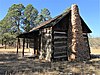 | January 27, 1975 (#75000520) | 11 miles (18 km) north of Colorado Springs off Interstate 25 38°59′25″N 104°51′22″W / 38.990278°N 104.856111°W / 38.990278; -104.856111 (Pioneer Cabin) | United States Air Force Academy | |
| 76 | Plaza Hotel |  | September 1, 1983 (#83001317) | 830 N. Tejon St. 38°50′46″N 104°49′21″W / 38.846111°N 104.8225°W / 38.846111; -104.8225 (Plaza Hotel) | Colorado Springs | |
| 77 | Ponderosa Lodge |  | August 29, 2008 (#08000829) | 6145 Shoup Rd. 39°00′33″N 104°43′00″W / 39.009172°N 104.716532°W / 39.009172; -104.716532 (Ponderosa Lodge) | Colorado Springs | |
| 78 | Ida M. Rice House |  | November 21, 2006 (#06001049) | 1196 N. Cascade Ave. 38°51′02″N 104°49′28″W / 38.850556°N 104.824444°W / 38.850556; -104.824444 (Ida M. Rice House) | Colorado Springs | |
| 79 | Second Midland School |  | September 12, 1980 (#80000895) | 815 S. 25th St. 38°50′28″N 104°51′59″W / 38.841111°N 104.866389°W / 38.841111; -104.866389 (Second Midland School) | Colorado Springs | |
| 80 | Shove Memorial Chapel |  | May 22, 2005 (#05000426) | 1010 N. Tejon St. 38°50′52″N 104°49′16″W / 38.847778°N 104.821111°W / 38.847778; -104.821111 (Shove Memorial Chapel) | Colorado Springs | |
| 81 | Shrine of the Sun |  | November 3, 1994 (#94001229) | 4250 Cheyenne Mountain Zoo Rd. 38°46′20″N 104°51′44″W / 38.772222°N 104.862222°W / 38.772222; -104.862222 (Shrine of the Sun) | Colorado Springs | |
| 82 | St. Mary's Catholic Church |  | June 3, 1982 (#82002301) | 26 W. Kiowa St. 38°50′11″N 104°49′35″W / 38.836389°N 104.826389°W / 38.836389; -104.826389 (St. Mary's Catholic Church) | Colorado Springs | |
| 83 | Stockbridge House | 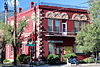 | September 11, 1980 (#80000896) | 2801 W. Colorado Ave. 38°51′00″N 104°52′01″W / 38.85°N 104.866944°W / 38.85; -104.866944 (Stockbridge House) | Colorado Springs | |
| 84 | Taylor Memorial Chapel |  | April 15, 1999 (#99000447) | 6145 Shoup Rd. 39°00′24″N 104°43′07″W / 39.006612°N 104.718495°W / 39.006612; -104.718495 (Taylor Memorial Chapel) | Colorado Springs | |
| 85 | Ticknor Hall |  | January 27, 2000 (#99001704) | 926 Cascade Ave. 38°50′55″N 104°49′30″W / 38.848611°N 104.825°W / 38.848611; -104.825 (Ticknor Hall) | Colorado Springs | |
| 86 | United States Air Force Academy, Cadet Area |  | April 1, 2004 (#04000484) | Roughly between Cadet Drive and Faculty Drive 39°00′40″N 104°53′08″W / 39.011031°N 104.885469°W / 39.011031; -104.885469 (United States Air Force Academy, Cadet Area) | United States Air Force Academy | |
| 87 | US Post Office and Federal Courthouse-Colorado Springs Main | 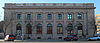 | January 22, 1986 (#86000170) | 210 Pikes Peak Ave. 38°50′00″N 104°49′15″W / 38.833333°N 104.820833°W / 38.833333; -104.820833 (US Post Office and Federal Courthouse-Colorado Springs Main) | Colorado Springs | |
| 88 | US Post Office-Manitou Springs Main | 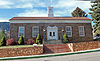 | January 24, 1986 (#86000181) | 307 Canon Ave. 38°51′36″N 104°55′03″W / 38.86°N 104.9175°W / 38.86; -104.9175 (US Post Office-Manitou Springs Main) | Manitou Springs | |
| 89 | Van Briggle Pottery Company |  | April 29, 2009 (#09000249) | 1125 Glen Ave./231 W. Uintah St. 38°51′02″N 104°49′46″W / 38.850631°N 104.829386°W / 38.850631; -104.829386 (Van Briggle Pottery Company) | Colorado Springs | |
| 90 | Wheeler Bank |  | September 12, 1980 (#80000898) | 717-719 Manitou Ave. 38°51′25″N 104°54′54″W / 38.856944°N 104.915°W / 38.856944; -104.915 (Wheeler Bank) | Manitou Springs | |
| 91 | S.A. Wilson Elementary School |  | May 1, 2017 (#100000929) | 930 Leta Dr. 38°45′59″N 104°44′23″W / 38.766307°N 104.739715°W / 38.766307; -104.739715 (S.A. Wilson Elementary School) | Colorado Springs | |
| 92 | John Wolfe House |  | January 23, 2013 (#12001193) | 905 W. Cheyenne Rd. 38°48′00″N 104°50′35″W / 38.799952°N 104.843112°W / 38.799952; -104.843112 (John Wolfe House) | Colorado Springs | |
| 93 | Y.W.C.A. |  | September 10, 1979 (#79000602) | 130 E. Kiowa St. 38°50′08″N 104°49′17″W / 38.835556°N 104.821389°W / 38.835556; -104.821389 (Y.W.C.A.) | Colorado Springs |
Former listing
| [3] | Name on the Register | Image | Date listed | Date removed | Location | City or town | Description |
|---|---|---|---|---|---|---|---|
| 1 | Chief Theatre | Upload image | 1973 (#73002258) | Unknown | 21 1/2 E. Pikes Peak | Colorado Springs | Also known as the Burns Theatre. Demolished in 1973. |
| 2 | Cragmor Sanatorium | Upload image | May 29, 1989 (#98000586) | September 16, 2002 | 1420 Austin Bluffs Parkway | Colorado Springs | Significantly reconstructed in 2001.[8] |
See also
 History portal
 United States portal
 Colorado portal
 National Register of Historic Places portal


- List of National Historic Landmarks in Colorado
- List of National Register of Historic Places in Colorado
- Bibliography of Colorado
- Geography of Colorado
- History of Colorado
- Index of Colorado-related articles
- List of Colorado-related lists
- Outline of Colorado
References
- ^ The latitude and longitude information provided in this table was derived originally from the National Register Information System, which has been found to be fairly accurate for about 99% of listings. Some locations in this table may have been corrected to current GPS standards.
- ^ National Park Service, United States Department of the Interior, "National Register of Historic Places: Weekly List Actions", retrieved August 30, 2024.
- ^ a b Numbers represent an alphabetical ordering by significant words. Various colorings, defined here, differentiate National Historic Landmarks and historic districts from other NRHP buildings, structures, sites or objects.
- ^ "National Register Information System". National Register of Historic Places. National Park Service. July 9, 2010.
- ^ The eight-digit number below each date is the number assigned to each location in the National Register Information System database, which can be viewed by clicking the number.
- ^ "Directory of Railroad Properties in the Colorado State REgister of Historic Properties, Fourth Edition" (PDF). History Colorado. Office of Archaeology and Historic Preservation. Retrieved July 29, 2016.
- ^ "Highway 24 Bridge Project Begins". Colorado Department of Transportation. January 9, 2012. Archived from the original on December 5, 2013. Retrieved December 5, 2013.
- ^ "Colorado Office of Archaeology and Historic Preservation | Properties removed from the National and State Registers". Archived from the original on 2012-08-18. Retrieved 2012-08-17.
External links
Wikimedia Commons has media related to El Paso County, Colorado.
- State of Colorado
- History Colorado
- El Paso County, Colorado
| |
|---|---|
| Topics | |
| Lists by state |
|
| Lists by insular areas | |
| Lists by associated state | |
| Other areas | |
| Related | |
| |


Municipalities and communities of El Paso County, Colorado, United States | ||
|---|---|---|
County seat: Colorado Springs | ||
| Cities |  | |
| Towns | ||
| CDPs | ||
| Unincorporated communities | ||
| Ghost towns | ||
| Footnotes | ‡This populated place also has portions in an adjacent county or counties | |
| ||
| |
|---|---|
Denver (capital) | |
| Topics |
|
| Society | |
| Cities |
|
| Counties |
|
| Regions |
|
 Colorado portal Colorado portal | |
| |||||||||||||||||||||||||||||||||
|---|---|---|---|---|---|---|---|---|---|---|---|---|---|---|---|---|---|---|---|---|---|---|---|---|---|---|---|---|---|---|---|---|---|
| Federal |
| ||||||||||||||||||||||||||||||||
| State |
| ||||||||||||||||||||||||||||||||
| Trails |
| ||||||||||||||||||||||||||||||||
38°49′55″N 104°31′31″W / 38.8320°N 104.5254°W / 38.8320; -104.5254 (El Paso County, Colorado)


