National Register of Historic Places listings in Gage County, Nebraska

This is a list of the National Register of Historic Places listings in Gage County, Nebraska.
This is intended to be a complete list of the properties and districts on the National Register of Historic Places in Gage County, Nebraska, United States. The locations of National Register properties and districts for which the latitude and longitude coordinates are included below, may be seen in a map.[1]
There are 31 properties and districts listed on the National Register in the county, and one former listing.
This National Park Service list is complete through NPS recent listings posted September 5, 2024.[2]
Map all coordinates using OpenStreetMap
Download coordinates as:
- KML
- GPX (all coordinates)
- GPX (primary coordinates)
- GPX (secondary coordinates)
Current listings
| [3] | Name on the Register | Image | Date listed[4] | Location | City or town | Description |
|---|---|---|---|---|---|---|
| 1 | Barneston Site | Upload image | January 21, 1974 (#74001117) | Address Restricted | Barneston | |
| 2 | Beatrice Chautauqua Pavilion and Gatehouse |  | April 9, 1979 (#79001445) | 6th and Grable Sts. 40°15′08″N 96°44′21″W / 40.25217°N 96.73905°W / 40.25217; -96.73905 (Beatrice Chautauqua Pavilion and Gatehouse) | Beatrice | |
| 3 | Beatrice City Library |  | July 12, 1976 (#76001131) | 220 N. 5th St. 40°16′04″N 96°44′53″W / 40.26769°N 96.74796°W / 40.26769; -96.74796 (Beatrice City Library) | Beatrice | |
| 4 | Beatrice Downtown Historic District |  | July 25, 2016 (#16000481) | Centered on 6th and Court Streets 40°15′57″N 96°44′48″W / 40.265863°N 96.746753°W / 40.265863; -96.746753 (Beatrice Downtown Historic District) | Beatrice | |
| 5 | Beatrice Municipal Auditorium |  | November 16, 2005 (#05001293) | 205 N. 4th St. 40°16′02″N 96°45′01″W / 40.26733°N 96.75015°W / 40.26733; -96.75015 (Beatrice Municipal Auditorium) | Beatrice | |
| 6 | Big Indian Creek Bridge |  | June 29, 1992 (#92000760) | Township road over Big Indian Creek, 3 miles (4.8 km) southwest of Wymore 40°05′13″N 96°43′22″W / 40.086944°N 96.722778°W / 40.086944; -96.722778 (Big Indian Creek Bridge) | Wymore | |
| 7 | Bloody Run Bridge |  | June 29, 1992 (#92000759) | Township road over Bloody Run, 4 miles (6.4 km) southwest of Virginia 40°15′44″N 96°44′15″W / 40.262093°N 96.737572°W / 40.262093; -96.737572 (Bloody Run Bridge) | Virginia | Moved to Beatrice, where it serves as a footbridge at Big Blue Water Park |
| 8 | Blue Springs Site | Upload image | August 14, 1973 (#73001063) | Address Restricted | Blue Springs | |
| 9 | Lake Bridenthal House |  | February 24, 1983 (#83001095) | 113 S. 9th St. 40°07′19″N 96°39′55″W / 40.12182°N 96.6652°W / 40.12182; -96.6652 (Lake Bridenthal House) | Wymore | |
| 10 | Bridge |  | June 29, 1992 (#92000761) | Township road over Sicily Creek, 6 miles (9.7 km) northwest of Wymore 40°09′06″N 96°47′03″W / 40.151667°N 96.784167°W / 40.151667; -96.784167 (Bridge) | Wymore | Apparently no longer extant[5] |
| 11 | Burlington Northern Depot |  | May 2, 1975 (#75001092) | 101 N. 2nd St.[6] 40°15′59″N 96°45′10″W / 40.26643°N 96.75286°W / 40.26643; -96.75286 (Burlington Northern Depot) | Beatrice | Now the Gage County Historical Society Museum.[6] |
| 12 | Centenary Methodist Episcopal Church |  | March 6, 2023 (#100008674) | 608 Elk St. 40°16′05″N 96°44′47″W / 40.2680°N 96.7463°W / 40.2680; -96.7463 (Centenary Methodist Episcopal Church) | Beatrice | |
| 12 | Christ Church Episcopal |  | November 29, 1999 (#99001389) | 520 N. 5th St. 40°16′18″N 96°44′52″W / 40.27155°N 96.74784°W / 40.27155; -96.74784 (Christ Church Episcopal) | Beatrice | |
| 13 | DeWitt Flour Mills and King Iron Bridge |  | December 27, 1978 (#78001699) | East of DeWitt on the Big Blue River 40°23′31″N 96°54′15″W / 40.39191°N 96.90408°W / 40.39191; -96.90408 (DeWitt Flour Mills and King Iron Bridge) | DeWitt | |
| 14 | Marion and Ruth Ann Dole House |  | December 10, 2010 (#10001003) | 1908 S. 4th St. 40°14′46″N 96°44′55″W / 40.24601°N 96.74862°W / 40.24601; -96.74862 (Marion and Ruth Ann Dole House) | Beatrice | |
| 15 | Farmers State Bank |  | June 11, 1992 (#92000702) | 601 Main 40°27′35″N 96°30′31″W / 40.45974°N 96.50854°W / 40.45974; -96.50854 (Farmers State Bank) | Adams | |
| 16 | Elijah Filley Stone Barn |  | April 11, 1977 (#77000830) | 13282 E. Scott Road[7] 40°15′47″N 96°32′27″W / 40.26308°N 96.54075°W / 40.26308; -96.54075 (Elijah Filley Stone Barn) | Filley | |
| 17 | First Commercial Bank |  | November 15, 2007 (#07001190) | 301 Main St. 40°03′00″N 96°48′07″W / 40.04999°N 96.802°W / 40.04999; -96.802 (First Commercial Bank) | Odell | |
| 18 | First Trinity Lutheran Church |  | August 4, 2016 (#16000514) | 11668 W. Highway 4 40°18′24″N 96°52′45″W / 40.306680°N 96.879231°W / 40.306680; -96.879231 (First Trinity Lutheran Church) | Beatrice | Built in 1905[8] |
| 19 | Gage County Courthouse |  | January 10, 1990 (#89002226) | 612 Grant St. 40°16′16″N 96°44′46″W / 40.27123°N 96.74601°W / 40.27123; -96.74601 (Gage County Courthouse) | Beatrice | |
| 20 | Homestead National Monument of America |  | October 15, 1966 (#66000115) | 4.5 miles (7.2 km) northwest of Beatrice on Nebraska Highway 4 40°17′15″N 96°50′07″W / 40.2875°N 96.835278°W / 40.2875; -96.835278 (Homestead National Monument of America) | Beatrice | |
| 21 | Hoyt Street Bridge |  | June 29, 1992 (#92000758) | Vacated township road over the Big Blue River 40°16′39″N 96°46′42″W / 40.27744°N 96.77823°W / 40.27744; -96.77823 (Hoyt Street Bridge) | Beatrice | |
| 22 | Institution for Feeble Minded Youth Farm |  | December 8, 1997 (#97001521) | 25478 S. 23rd Rd.[9] 40°16′28″N 96°41′22″W / 40.2744°N 96.6895°W / 40.2744; -96.6895 (Institution for Feeble Minded Youth Farm) | Beatrice | Now the Carriage House Bed & Breakfast |
| 23 | Johnson Cabin Museum |  | July 27, 2015 (#15000488) | Blue Springs Park 40°08′26″N 96°39′44″W / 40.140662°N 96.662267°W / 40.140662; -96.662267 (Johnson Cabin Museum) | Blue Springs | |
| 24 | Samuel D. Kilpatrick House | 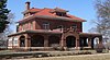 | December 20, 1984 (#84000476) | 701 N. 7th St. 40°16′23″N 96°44′45″W / 40.2731°N 96.74582°W / 40.2731; -96.74582 (Samuel D. Kilpatrick House) | Beatrice | |
| 25 | Mission Creek Bridge |  | June 29, 1992 (#92000762) | County road over Mission Creek, 7 miles (11 km) southwest of Barneston 40°00′15″N 96°27′48″W / 40.004167°N 96.463333°W / 40.004167; -96.463333 (Mission Creek Bridge) | Barneston | |
| 26 | North Seventh Street Historic District | 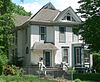 | March 10, 2010 (#10000067) | N. 7th St. bounded by Garfield St. on the north and Washington St. on the south 40°16′27″N 96°44′43″W / 40.274264°N 96.745264°W / 40.274264; -96.745264 (North Seventh Street Historic District) | Beatrice | |
| 27 | North Eleventh Street Historic District | 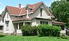 | March 10, 2010 (#10000068) | N. 11th St. bounded by Garfield St. on the north and Lincoln St. on the south 40°16′26″N 96°44′23″W / 40.273772°N 96.739792°W / 40.273772; -96.739792 (North Eleventh Street Historic District) | Beatrice | |
| 28 | Paddock Hotel |  | November 30, 1987 (#87002084) | 105 N. 6th St. 40°15′58″N 96°44′50″W / 40.2662°N 96.74712°W / 40.2662; -96.74712 (Paddock Hotel) | Beatrice | |
| 29 | Rachel Kilpatrick Purdy House |  | November 8, 2006 (#06000995) | 1201 N. 11th St. 40°16′42″N 96°44′25″W / 40.27827°N 96.74025°W / 40.27827; -96.74025 (Rachel Kilpatrick Purdy House) | Beatrice | |
| 30 | J. Schmuck Block |  | July 2, 2008 (#08000598) | 113 N. 5th St. 40°15′59″N 96°44′54″W / 40.26649°N 96.74847°W / 40.26649; -96.74847 (J. Schmuck Block) | Beatrice |
Former listings
| [3] | Name on the Register | Image | Date listed | Date removed | Location | City or town | Description |
|---|---|---|---|---|---|---|---|
| 1 | Algernon S. Paddock House |  | March 14, 1973 (#73001062) | March 25, 2019 | 1401 N. 10th St. 40°16′49″N 96°44′28″W / 40.280278°N 96.741111°W / 40.280278; -96.741111 (Algernon S. Paddock House) | Beatrice | No longer extant[10] |
See also
Wikimedia Commons has media related to National Register of Historic Places in Gage County, Nebraska.
- List of National Historic Landmarks in Nebraska
- National Register of Historic Places listings in Nebraska
References
- ^ The latitude and longitude information provided in this table was derived originally from the National Register Information System, which has been found to be fairly accurate for about 99% of listings. Some locations in this table may have been corrected to current GPS standards.
- ^ National Park Service, United States Department of the Interior, "National Register of Historic Places: Weekly List Actions", retrieved September 5, 2024.
- ^ a b Numbers represent an alphabetical ordering by significant words. Various colorings, defined here, differentiate National Historic Landmarks and historic districts from other NRHP buildings, structures, sites or objects.
- ^ The eight-digit number below each date is the number assigned to each location in the National Register Information System database, which can be viewed by clicking the number.
- ^ The NRHP nominating form[usurped] describes and depicts a pony truss bridge. The bridge at this site in 2013 was a beam bridge: see photo. According to uglybridges.com, the current bridge was built in 2003.
- ^ a b "Gage County Historical Society Museum". Gage County, Nebraska. Retrieved 2012-03-22.
- ^ "Filley Stone Barn". Gage County Historical Society and Museum. Retrieved 2013-05-31.
- ^ "History". First Trinity Lutheran Church. Retrieved 2016-09-17.
- ^ "Carriage House Bed & Breakfast". Archived 2012-03-20 at the Wayback Machine Retrieved 2012-03-23.
- ^ A placard at the Gage County Historical Society Museum refers to "the Paddock-Lang home that was located at 1401 N. 10th". A historic photo of the house is part of the museum's Paddock display; it can be seen in the upper left of this photo of the display. The house in the historic photo does not resemble the house at that address in March 2012, photos of which are in Commons:Category:Beatrice, Nebraska 1401 N. 10th Street.
- v
- t
- e

- Adams
- Antelope
- Arthur
- Banner
- Blaine
- Boone
- Box Butte
- Boyd
- Brown
- Buffalo
- Burt
- Butler
- Cass
- Cedar
- Chase
- Cherry
- Cheyenne
- Clay
- Colfax
- Cuming
- Custer
- Dakota
- Dawes
- Dawson
- Deuel
- Dixon
- Dodge
- Douglas
- Dundy
- Fillmore
- Franklin
- Frontier
- Furnas
- Gage
- Garden
- Garfield
- Gosper
- Grant
- Greeley
- Hall
- Hamilton
- Harlan
- Hayes
- Hitchcock
- Holt
- Hooker
- Howard
- Jefferson
- Johnson
- Kearney
- Keith
- Keya Paha
- Kimball
- Knox
- Lancaster
- Lincoln
- Logan
- Loup
- Madison
- McPherson
- Merrick
- Morrill
- Nance
- Nemaha
- Nuckolls
- Otoe
- Pawnee
- Perkins
- Phelps
- Pierce
- Platte
- Polk
- Red Willow
- Richardson
- Rock
- Saline
- Sarpy
- Saunders
- Scotts Bluff
- Seward
- Sheridan
- Sherman
- Sioux
- Stanton
- Thayer
- Thomas
- Thurston
- Valley
- Washington
- Wayne
- Webster
- Wheeler
- York
- Bridges
- Historic districts
- Houses
- National Historic Landmarks
- Properties of religious function
- Railway stations
 Category
 List
List National Register of Historic Places Portal


