National Register of Historic Places listings in Gwinnett County, Georgia

This is a list of properties and districts in Gwinnett County, Georgia that are listed on the National Register of Historic Places (NRHP).
Map all coordinates using OpenStreetMap
Download coordinates as:
- KML
- GPX (all coordinates)
- GPX (primary coordinates)
- GPX (secondary coordinates)
This National Park Service list is complete through NPS recent listings posted September 5, 2024.[1]
- v
- t
- e
Properties on the National Register of Historic Places in Georgia by county
- Appling
- Atkinson
- Bacon
- Baker
- Baldwin
- Banks
- Barrow
- Bartow
- Ben Hill
- Berrien
- Bibb
- Bleckley
- Brantley
- Brooks
- Bryan
- Bulloch
- Burke
- Butts
- Calhoun
- Camden
- Candler
- Carroll
- Catoosa
- Charlton
- Chatham
- Chattahoochee
- Chattooga
- Cherokee
- Clarke
- Clay
- Clayton
- Clinch
- Cobb
- Coffee
- Colquitt
- Columbia
- Cook
- Coweta
- Crawford
- Crisp
- Dade
- Dawson
- Decatur
- DeKalb
- Dodge
- Dooly
- Dougherty
- Douglas
- Early
- Echols
- Effingham
- Elbert
- Emanuel
- Evans
- Fannin
- Fayette
- Floyd
- Forsyth
- Franklin
- Fulton
- Gilmer
- Glascock
- Glynn
- Gordon
- Grady
- Greene
- Gwinnett
- Habersham
- Hall
- Hancock
- Haralson
- Harris
- Hart
- Heard
- Henry
- Houston
- Irwin
- Jackson
- Jasper
- Jeff Davis
- Jefferson
- Jenkins
- Johnson
- Jones
- Lamar
- Lanier
- Laurens
- Lee
- Liberty
- Lincoln
- Long
- Lowndes
- Lumpkin
- Macon
- Madison
- Marion
- McDuffie
- McIntosh
- Meriwether
- Miller
- Mitchell
- Monroe
- Montgomery
- Morgan
- Murray
- Muscogee
- Newton
- Oconee
- Oglethorpe
- Paulding
- Peach
- Pickens
- Pierce
- Pike
- Polk
- Pulaski
- Putnam
- Quitman
- Rabun
- Randolph
- Richmond
- Rockdale
- Schley
- Screven
- Seminole
- Spalding
- Stephens
- Stewart
- Sumter
- Talbot
- Taliaferro
- Tattnall
- Taylor
- Telfair
- Terrell
- Thomas
- Tift
- Toombs
- Towns
- Treutlen
- Troup
- Turner
- Twiggs
- Union
- Upson
- Walker
- Walton
- Ware
- Warren
- Washington
- Wayne
- Webster
- Wheeler
- White
- Whitfield
- Wilcox
- Wilkes
- Wilkinson
- Worth

Current listings
| [2] | Name on the Register | Image | Date listed[3] | Location | City or town | Description |
|---|---|---|---|---|---|---|
| 1 | Alcovy Road Grist Mill | 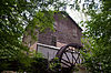 | July 23, 1998 (#98000885) | 1564 Alcovy Rd. 33°57′46″N 83°55′35″W / 33.962778°N 83.926389°W / 33.962778; -83.926389 (Alcovy Road Grist Mill) | Dacula | |
| 2 | Bona Allen House |  | September 1, 1983 (#83000231) | 395 Main St. 34°07′25″N 84°00′01″W / 34.123611°N 84.000278°W / 34.123611; -84.000278 (Bona Allen House) | Buford | |
| 3 | John Quincy Allen House |  | January 12, 1984 (#84001109) | 345 E. Main St. 34°07′21″N 84°00′04″W / 34.1225°N 84.001111°W / 34.1225; -84.001111 (John Quincy Allen House) | Buford | |
| 4 | Bona Allen Shoe and Horse Collar Factory |  | January 3, 2005 (#04001138) | 554 W. Main St. 34°06′50″N 84°00′43″W / 34.113889°N 84.011944°W / 34.113889; -84.011944 (Bona Allen Shoe and Horse Collar Factory) | Buford | |
| 5 | Buford Public School Auditorium | Upload image | August 5, 2009 (#09000586) | 4975 Little Mill Rd. 34°07′10″N 84°00′38″W / 34.119467°N 84.010433°W / 34.119467; -84.010433 (Buford Public School Auditorium) | Buford | |
| 6 | Robert Craig Plantation |  | June 8, 1990 (#90000805) | 1504 Five Forks Trickum Rd. 33°54′24″N 84°00′59″W / 33.906667°N 84.016389°W / 33.906667; -84.016389 (Robert Craig Plantation) | Lawrenceville | |
| 7 | Gwinnett County Courthouse |  | September 18, 1980 (#80001084) | Courthouse Sq. 33°57′24″N 83°59′21″W / 33.956667°N 83.989167°W / 33.956667; -83.989167 (Gwinnett County Courthouse) | Lawrenceville | |
| 8 | Mechanicsville School |  | October 16, 1980 (#80001085) | 3980 Florida Ave. Northwest 33°55′43″N 84°14′50″W / 33.928611°N 84.247222°W / 33.928611; -84.247222 (Mechanicsville School) | Peachtree Corners | Formerly located in unincorporated Gwinnett County (near Norcross), now within the city limits of Peachtree Corners. The building is typical of early 20th Century rural schoolhouse architecture. The school was a fixture of the Mechanicsville community in the early 1900s. |
| 9 | Norcross Historic District |  | November 21, 1980 (#80001086) | Off U.S. 23 33°56′33″N 84°12′44″W / 33.9425°N 84.212222°W / 33.9425; -84.212222 (Norcross Historic District) | Norcross | |
| 10 | Old Seminary Building |  | December 29, 1970 (#70000206) | 455 Perry St. 33°57′09″N 83°59′20″W / 33.9525°N 83.9890°W / 33.9525; -83.9890 (Old Seminary Building) | Lawrenceville | |
| 11 | Parks-Strickland Archeological Complex |  | December 8, 1989 (#89002034) | Little Mulberry Park 34°02′29″N 83°53′04″W / 34.0413°N 83.884511°W / 34.0413; -83.884511 (Parks-Strickland Archeological Complex) | Dacula | |
| 12 | The Superb |  | March 9, 1999 (#98001560) | 3595 S. Old Peachtree Rd. 33°59′19″N 84°09′20″W / 33.988611°N 84.155556°W / 33.988611; -84.155556 (The Superb) | Duluth | Railroad car that was used by U.S. President Harding |
| 13 | Suwanee Historic District | 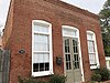 | December 24, 2013 (#13000966) | Main, Russell & White Sts., Stonecypher & Scales Rds., N & S Railroad 34°03′10″N 84°04′27″W / 34.052819°N 84.074228°W / 34.052819; -84.074228 (Suwanee Historic District) | Suwanee | |
| 14 | William Terrell Homeplace | Upload image | August 26, 1982 (#82002423) | E of Lawrenceville off US 29 33°57′59″N 83°57′58″W / 33.966389°N 83.966111°W / 33.966389; -83.966111 (William Terrell Homeplace) | Lawrenceville | |
| 15 | Clarence R. Ware House |  | June 17, 1982 (#82002424) | 293 N. Perry St. 33°57′30″N 83°59′25″W / 33.958333°N 83.990278°W / 33.958333; -83.990278 (Clarence R. Ware House) | Lawrenceville | |
| 16 | Elisha Winn House |  | December 18, 1979 (#79000728) | N of Dacula at 908 Dacula Rd. 34°01′24″N 83°54′30″W / 34.02345°N 83.90821°W / 34.02345; -83.90821 (Elisha Winn House) | Dacula | |
| 17 | Thomas Wynne House |  | July 8, 1977 (#77000436) | N of Lilburn on U.S. 29 33°53′57″N 84°08′17″W / 33.899167°N 84.138056°W / 33.899167; -84.138056 (Thomas Wynne House) | Lilburn |
Former listings
| [2] | Name on the Register | Image | Date listed | Date removed | Location | City or town | Description |
|---|---|---|---|---|---|---|---|
| 1 | Isaac Adair House |  | November 29, 2000 (#00001390) | February 6, 2020 | 15 S Clayton St 33°55′31″N 83°57′20″W / 33.925278°N 83.955556°W / 33.925278; -83.955556 (Isaac Adair House) | Lawrenceville | Relocated to its current location in 2008 due to construction of the Sugarloaf Parkway through its previous location. |
| 2 | Hudson-Nash House and Cemetery |  | January 4, 1990 (#89002264) | April 26, 2019 | 3490 Five Forks Trickum Rd. 33°52′29″N 84°04′21″W / 33.874722°N 84.0725°W / 33.874722; -84.0725 (Hudson-Nash House and Cemetery) | Lilburn | Delisted due to relocation to Yellow River Post Office Park. |
See also
Wikimedia Commons has media related to National Register of Historic Places in Gwinnett County, Georgia.
- National Register of Historic Places listings in Georgia (U.S. state)
- List of National Historic Landmarks in Georgia (U.S. state)
References
- ^ National Park Service, United States Department of the Interior, "National Register of Historic Places: Weekly List Actions", retrieved September 5, 2024.
- ^ a b Numbers represent an alphabetical ordering by significant words. Various colorings, defined here, differentiate National Historic Landmarks and historic districts from other NRHP buildings, structures, sites or objects.
- ^ The eight-digit number below each date is the number assigned to each location in the National Register Information System database, which can be viewed by clicking the number.
| |
|---|---|
| Topics | |
| Lists by state |
|
| Lists by insular areas | |
| Lists by associated state | |
| Other areas | |
| Related | |
| |


