National Register of Historic Places listings in Hempstead County, Arkansas

This is a list of the National Register of Historic Places listings in Hempstead County, Arkansas.
This is intended to be a complete list of the properties and districts on the National Register of Historic Places in Hempstead County, Arkansas, United States. The locations of National Register properties and districts for which the latitude and longitude coordinates are included below, may be seen in a map.[1]
There are 28 properties and districts listed on the National Register in the county, including 1 National Historic Landmark. Another 6 properties were once listed but have been removed.
This National Park Service list is complete through NPS recent listings posted September 13, 2024.[2]
Map all coordinates using OpenStreetMap
Download coordinates as:
- KML
- GPX (all coordinates)
- GPX (primary coordinates)
- GPX (secondary coordinates)
Current listings
| [3] | Name on the Register[4] | Image | Date listed[5] | Location | City or town | Description |
|---|---|---|---|---|---|---|
| 1 | Brundidge Building |  | March 27, 1990 (#90000431) | W. 2nd St. 33°40′03″N 93°35′32″W / 33.6675°N 93.592222°W / 33.6675; -93.592222 (Brundidge Building) | Hope | |
| 2 | Bill Clinton Birthplace |  | May 19, 1994 (#94000472) | 117 S. Hervey St. 33°40′02″N 93°35′47″W / 33.667222°N 93.596389°W / 33.667222; -93.596389 (Bill Clinton Birthplace) | Hope | |
| 3 | Confederate State Capitol | 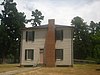 | May 19, 1972 (#72000203) | Main St. 33°46′43″N 93°40′41″W / 33.778611°N 93.678056°W / 33.778611; -93.678056 (Confederate State Capitol) | Washington | One of the Camden Expedition Sites, a National Historic Landmark consisting of sites in several counties |
| 4 | Dooley's Ferry Fortifications Historic District |  | September 22, 2004 (#04001031) | On the bluffs above Dooley's Ferry[6] 33°30′47″N 93°44′32″W / 33.513056°N 93.742222°W / 33.513056; -93.742222 (Dooley's Ferry Fortifications Historic District) | Spring Hill | |
| 5 | First Presbyterian Church | Upload image | January 12, 2024 (#100009766) | 701 South Main Street 33°39′47″N 93°35′24″W / 33.6630°N 93.5901°W / 33.6630; -93.5901 (First Presbyterian Church) | Hope | |
| 5 | Foster House |  | June 5, 1991 (#91000683) | 420 S. Spruce St. 33°40′00″N 93°35′04″W / 33.666667°N 93.584444°W / 33.666667; -93.584444 (Foster House) | Hope | 1918 American Foursquare with Prairie and Craftsman details |
| 6 | Goodlett Gin |  | January 17, 1975 (#75000387) | 799 Franklin St. 33°46′48″N 93°40′41″W / 33.78°N 93.678056°W / 33.78; -93.678056 (Goodlett Gin) | Washington | |
| 7 | E.S. Greening House | Upload image | July 9, 1987 (#87001147) | 707 E. Division St. 33°40′16″N 93°34′52″W / 33.671111°N 93.581111°W / 33.671111; -93.581111 (E.S. Greening House) | Hope | burned down |
| 8 | Hempstead County Courthouse |  | May 19, 1994 (#94000442) | Northwestern corner of the junction of 5th and Washington Sts. 33°39′52″N 93°35′55″W / 33.664444°N 93.598611°W / 33.664444; -93.598611 (Hempstead County Courthouse) | Hope | 1939 Art Deco courthouse |
| 9 | Hope Girl Scout Little House |  | January 27, 2015 (#14001199) | NE. corner of Jones St. & Fair Park 33°39′31″N 93°36′25″W / 33.6587°N 93.6069°W / 33.6587; -93.6069 (Hope Girl Scout Little House) | Hope | |
| 10 | Hope Historic Commercial District | 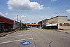 | July 28, 1995 (#95000905) | Roughly bounded by the Union Pacific railroad tracks, Louisiana St., 3rd St. and Walnut St. 33°40′04″N 93°35′32″W / 33.667778°N 93.592222°W / 33.667778; -93.592222 (Hope Historic Commercial District) | Hope | |
| 11 | McRae House |  | December 22, 1982 (#82000826) | 1113 E. 3rd St. 33°40′04″N 93°34′45″W / 33.667778°N 93.579167°W / 33.667778; -93.579167 (McRae House) | Hope | |
| 12 | Missouri Pacific Railroad Depot-Hope | 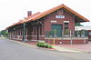 | June 11, 1992 (#92000610) | North of the junction of E. Division and Main Sts. 33°40′08″N 93°35′32″W / 33.668889°N 93.592222°W / 33.668889; -93.592222 (Missouri Pacific Railroad Depot-Hope) | Hope | Reopened as Hope (Amtrak station) on April 4, 2013. |
| 13 | Mounds Cemetery | Upload image | June 5, 2013 (#13000350) | County Road 13 northwest of Hempstead[7] 33°46′48″N 93°49′22″W / 33.780000°N 93.822778°W / 33.780000; -93.822778 (Mounds Cemetery) | Columbus | Resting place of Hempstead County's first pioneers, built around a pair of Indian mounds[8] |
| 14 | North Elm Street Historic District | 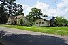 | July 28, 1995 (#95000904) | Roughly bounded by the Union Pacific railroad tracks, Hervey St., G Ave. and Hazel St. 33°40′17″N 93°35′39″W / 33.671389°N 93.594167°W / 33.671389; -93.594167 (North Elm Street Historic District) | Hope | 1890-1945 collection of 54 structures in various architectural styles |
| 15 | North Washington Street Historic District |  | July 28, 1995 (#95000903) | Eastern side of N. Washington St. between B and E Sts. 33°40′12″N 93°35′58″W / 33.67°N 93.599444°W / 33.67; -93.599444 (North Washington Street Historic District) | Hope | |
| 16 | Oak Grove Missionary Baptist Church | 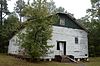 | May 29, 2003 (#03000463) | County Road 16 33°49′57″N 93°36′39″W / 33.8325°N 93.610833°W / 33.8325; -93.610833 (Oak Grove Missionary Baptist Church) | Blevins | |
| 17 | Grandison D. Royston House |  | June 21, 1971 (#71000124) | Water St., southwest of Columbus St. 33°46′20″N 93°40′54″W / 33.7721°N 93.6818°W / 33.7721; -93.6818 (Grandison D. Royston House) | Washington | |
| 18 | Nesburt T. Ruggles House |  | December 9, 1994 (#94001463) | Eastern side of Highway 32, southeast of Shover Springs 33°36′59″N 93°31′33″W / 33.616389°N 93.525833°W / 33.616389; -93.525833 (Nesburt T. Ruggles House) | Shover Springs | |
| 19 | St. Mark's Episcopal Church | 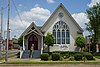 | May 6, 1976 (#76000414) | 3rd and Elm Sts. 33°39′59″N 93°35′33″W / 33.666389°N 93.5925°W / 33.666389; -93.5925 (St. Mark's Episcopal Church) | Hope | 1904 church in Gothic Revival style |
| 20 | Southwestern Proving Ground Airport Historic District | 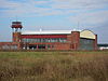 | June 10, 1999 (#99000230) | Hope Municipal Airport, Airport Rd. 33°43′17″N 93°39′03″W / 33.721389°N 93.650833°W / 33.721389; -93.650833 (Southwestern Proving Ground Airport Historic District) | Hope | 1941 munitions testing complex |
| 21 | Southwestern Proving Ground Building No. 4 | Upload image | January 22, 2009 (#08001339) | 259 County Road 279 33°44′28″N 93°36′38″W / 33.740978°N 93.610492°W / 33.740978; -93.610492 (Southwestern Proving Ground Building No. 4) | Hope | |
| 22 | Southwestern Proving Ground Building No. 5 | Upload image | January 22, 2009 (#09001247) | 259 County Road 279 33°44′28″N 93°36′38″W / 33.740978°N 93.610492°W / 33.740978; -93.610492 (Southwestern Proving Ground Building No. 5) | Hope | |
| 23 | Southwestern Proving Ground Building No. 129 | Upload image | January 29, 2009 (#08001373) | 195 County Road 279 33°44′23″N 93°36′35″W / 33.739594°N 93.609808°W / 33.739594; -93.609808 (Southwestern Proving Ground Building No. 129) | Hope | |
| 24 | Southwestern Proving Ground Officers Quarters Historic District | 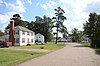 | July 8, 2008 (#08000437) | 359-383 Oakhaven 33°43′44″N 93°37′10″W / 33.728889°N 93.619347°W / 33.728889; -93.619347 (Southwestern Proving Ground Officers Quarters Historic District) | Oakhaven | |
| 25 | Ward-Jackson House |  | September 14, 1989 (#89001421) | 122 N. Louisiana 33°40′10″N 93°35′43″W / 33.669444°N 93.595278°W / 33.669444; -93.595278 (Ward-Jackson House) | Hope | 1903 Victorian house |
| 26 | Washington Confederate Monument | 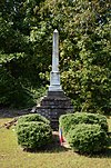 | December 6, 1996 (#96001410) | US 278, northwest of its junction with Highway 32 33°46′30″N 93°41′28″W / 33.775°N 93.691111°W / 33.775; -93.691111 (Washington Confederate Monument) | Washington | |
| 27 | Washington Historic District | 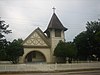 | June 20, 1972 (#72000204) | Boundaries correspond to original 1824 plat of city 33°40′51″N 93°38′53″W / 33.680833°N 93.648056°W / 33.680833; -93.648056 (Washington Historic District) | Washington |
Former listings
| [3] | Name on the Register | Image | Date listed | Date removed | Location | City or town | Description |
|---|---|---|---|---|---|---|---|
| 1 | Carrigan House | 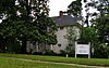 | July 20, 1978 (#78000591) | January 23, 2008 | 704 W. Avenue B | Hope | Delisted due to extensive alterations. |
| 2 | Columbus Presbyterian Church | Upload image | November 17, 1982 (#82000823) | June 12, 2013 | Highway 73 33°46′42″N 93°49′03″W / 33.778333°N 93.8175°W / 33.778333; -93.8175 (Columbus Presbyterian Church) | Columbus | Destroyed by fire[8] |
| 3 | Ethridge House |  | December 1, 1993 (#93001259) | January 2, 2024 | 511 N. Main St. 33°40′25″N 93°35′37″W / 33.673611°N 93.593611°W / 33.673611; -93.593611 (Ethridge House) | Hope | |
| 4 | Foster House | 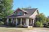 | December 22, 1982 (#82000825) | September 30, 2019 | 303 N. Hervey St. 33°40′10″N 93°35′49″W / 33.669444°N 93.596944°W / 33.669444; -93.596944 (Foster House) | Hope | |
| 5 | Dr. Thomas S. Jacques House | Upload image | November 3, 1989 (#89001940) | January 29, 2013 | Northwest of McCaskill | McCaskill | |
| 6 | K. G. McRae House | Upload image | May 4, 1976 (#76000413) | January 6, 2000 | 3rd and Edgewood Streets | Hope | Destroyed by fire in 1987. Not to be confused with the McRae House (82000826), which still stands and remains listed above. |
| 7 | Ozan Methodist Church | Upload image | November 5, 1982 (#82000827) | September 17, 1999 | Mulberry St. | Ozan |
See also
Wikimedia Commons has media related to National Register of Historic Places in Hempstead County, Arkansas.
- List of National Historic Landmarks in Arkansas
- National Register of Historic Places listings in Arkansas
References
- ^ The latitude and longitude information provided in this table was derived originally from the National Register Information System, which has been found to be fairly accurate for about 99% of listings. Some locations in this table may have been corrected to current GPS standards.
- ^ National Park Service, United States Department of the Interior, "National Register of Historic Places: Weekly List Actions", retrieved September 13, 2024.
- ^ a b Numbers represent an alphabetical ordering by significant words. Various colorings, defined here, differentiate National Historic Landmarks and historic districts from other NRHP buildings, structures, sites or objects.
- ^ "National Register Information System". National Register of Historic Places. National Park Service. March 13, 2009.
- ^ The eight-digit number below each date is the number assigned to each location in the National Register Information System database, which can be viewed by clicking the number.
- ^ Location derived from "August Fieldwork at Dooley's Ferry Archived 2011-07-20 at the Wayback Machine", Kadohadacho Chapter of the Arkansas Archeological Society, September 2008, accessed 2009-12-15; and coordinates derived from the GNIS feature record for Dooley's Ferry. The NRIS lists the site as "Address Restricted".
- ^ U.S. Geological Survey Geographic Names Information System: Mounds Cemetery
- ^ a b McLemore, Ken (April 10, 2013). "Cemetery on Nomination List". Hope Star. Retrieved June 18, 2013.
- v
- t
- e
- List of U.S. National Historic Landmarks by state:
- Alabama
- Alaska
- Arizona
- Arkansas
- California
- Colorado
- Connecticut
- Delaware
- Florida
- Georgia
- Hawaii
- Idaho
- Illinois
- Indiana
- Iowa
- Kansas
- Kentucky
- Louisiana
- Maine
- Maryland
- Massachusetts
- Michigan
- Minnesota
- Mississippi
- Missouri
- Montana
- Nebraska
- Nevada
- New Hampshire
- New Jersey
- New Mexico
- New York
- North Carolina
- North Dakota
- Ohio
- Oklahoma
- Oregon
- Pennsylvania
- Rhode Island
- South Carolina
- South Dakota
- Tennessee
- Texas
- Utah
- Vermont
- Virginia
- Washington
- West Virginia
- Wisconsin
- Wyoming
 National Register of Historic Places portal
 Category


Municipalities and communities of Hempstead County, Arkansas, United States | ||
|---|---|---|
County seat: Hope | ||
| Cities |  | |
| Towns | ||
| CDP | ||
| Other unincorporated communities | ||
| Footnotes | ‡This populated place also has portions in an adjacent county or counties | |
| ||


