National Register of Historic Places listings in Mason County, West Virginia

This is a list of the National Register of Historic Places listings in Mason County, West Virginia.
This is intended to be a complete list of the properties and districts on the National Register of Historic Places in Mason County, West Virginia, United States. The locations of National Register properties and districts for which the latitude and longitude coordinates are included below, may be seen in a Google map.[1]
There are 12 properties and districts listed on the National Register in the county.
This National Park Service list is complete through NPS recent listings posted July 12, 2024.[2]
Map all coordinates using OpenStreetMap
Download coordinates as:
- KML
- GPX (all coordinates)
- GPX (primary coordinates)
- GPX (secondary coordinates)
Barbour - Berkeley - Boone - Braxton - Brooke - Cabell - Calhoun - Clay - Doddridge - Fayette - Gilmer - Grant - Greenbrier - Hampshire - Hancock - Hardy - Harrison - Jackson - Jefferson - Kanawha - Lewis - Lincoln - Logan - Marion - Marshall - Mason - McDowell - Mercer - Mineral - Mingo - Monongalia - Monroe - Morgan - Nicholas - Ohio - Pendleton - Pleasants - Pocahontas - Preston - Putnam - Raleigh - Randolph - Ritchie - Roane - Summers - Taylor - Tucker - Tyler - Upshur - Wayne - Webster - Wetzel - Wirt - Wood - Wyoming |
Current listings
| [3] | Name on the Register[4] | Image | Date listed[5] | Location | City or town | Description |
|---|---|---|---|---|---|---|
| 1 | Couch-Artrip House |  | August 23, 1984 (#84003623) | U.S. Route 35 38°42′11″N 81°58′04″W / 38.703056°N 81.967778°W / 38.703056; -81.967778 (Couch-Artrip House) | Southside | |
| 2 | Eastham House | Upload image | February 24, 1989 (#88002669) | U.S. Route 35 38°47′27″N 82°03′53″W / 38.790833°N 82.064722°W / 38.790833; -82.064722 (Eastham House) | Point Pleasant | |
| 3 | Elm Grove | Upload image | July 16, 1992 (#92000897) | 2283 U.S. Route 35 N. 38°43′19″N 81°57′18″W / 38.721944°N 81.955°W / 38.721944; -81.955 (Elm Grove) | Southside | |
| 4 | The Gold Houses | 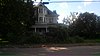 | July 9, 1997 (#97000784) | 503 and 505 N. 2nd St. 39°01′29″N 82°01′28″W / 39.024722°N 82.024444°W / 39.024722; -82.024444 (The Gold Houses) | Mason | |
| 5 | Lewis-Capehart-Roseberry House |  | August 29, 1979 (#79002590) | 1 Roseberry Lane 38°52′36″N 82°08′05″W / 38.876667°N 82.134722°W / 38.876667; -82.134722 (Lewis-Capehart-Roseberry House) | Point Pleasant | |
| 6 | Maplewood | Upload image | February 16, 2001 (#00000251) | 1951 U.S. Route 35 38°40′40″N 81°57′59″W / 38.677778°N 81.966389°W / 38.677778; -81.966389 (Maplewood) | Pliny | |
| 7 | Gen. John McCausland House |  | June 16, 1980 (#00000778) | U.S. Route 35; also Grape Hill 38°39′26″N 81°58′14″W / 38.657222°N 81.970556°W / 38.657222; -81.970556 (Gen. John McCausland House) | Leon | Grape Hill represents a boundary increase of July 5, 2000 |
| 8 | Point Pleasant Battleground |  | January 26, 1970 (#70000656) | Southwestern corner of Main and 1st Sts. 38°50′21″N 82°08′26″W / 38.839167°N 82.140556°W / 38.839167; -82.140556 (Point Pleasant Battleground) | Point Pleasant | |
| 9 | Point Pleasant Historic District |  | July 1, 1985 (#85001465) | Main St. between 1st and 11th and Viand St. between 8th and 10th 38°50′40″N 82°08′18″W / 38.844444°N 82.138333°W / 38.844444; -82.138333 (Point Pleasant Historic District) | Point Pleasant | |
| 10 | Powell-Redmond House |  | February 10, 1983 (#83003243) | 23 Columbia St. 39°00′05″N 82°02′23″W / 39.001389°N 82.039722°W / 39.001389; -82.039722 (Powell-Redmond House) | Clifton | |
| 11 | Shumaker-Lewis House | 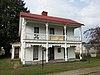 | March 26, 1979 (#79002589) | Brown St. 39°01′09″N 82°01′53″W / 39.019167°N 82.031389°W / 39.019167; -82.031389 (Shumaker-Lewis House) | Mason | |
| 12 | Smithland Farm | Upload image | October 17, 2003 (#03001061) | U.S. Route 35 between Lower Nine Mile Rd. and Lower Five Mile Rd. 38°46′42″N 82°03′02″W / 38.778333°N 82.050556°W / 38.778333; -82.050556 (Smithland Farm) | Henderson |
See also
Wikimedia Commons has media related to National Register of Historic Places in Mason County, West Virginia.
- List of National Historic Landmarks in West Virginia
- National Register of Historic Places listings in West Virginia
References
- ^ The latitude and longitude information provided in this table was derived originally from the National Register Information System, which has been found to be fairly accurate for about 99% of listings. Some locations in this table may have been corrected to current GPS standards.
- ^ National Park Service, United States Department of the Interior, "National Register of Historic Places: Weekly List Actions", retrieved July 12, 2024.
- ^ Numbers represent an alphabetical ordering by significant words. Various colorings, defined here, differentiate National Historic Landmarks and historic districts from other NRHP buildings, structures, sites or objects.
- ^ "National Register Information System". National Register of Historic Places. National Park Service. April 24, 2008.
- ^ The eight-digit number below each date is the number assigned to each location in the National Register Information System database, which can be viewed by clicking the number.
- v
- t
- e

county
- Barbour
- Berkeley
- Boone
- Braxton
- Brooke
- Cabell
- Calhoun
- Clay
- Doddridge
- Fayette
- Gilmer
- Grant
- Greenbrier
- Hampshire
- Hancock
- Hardy
- Harrison
- Jackson
- Jefferson
- Kanawha
- Lewis
- Lincoln
- Logan
- Marion
- Marshall
- Mason
- McDowell
- Mercer
- Mineral
- Mingo
- Monongalia
- Monroe
- Morgan
- Nicholas
- Ohio
- Pendleton
- Pleasants
- Pocahontas
- Preston
- Putnam
- Raleigh
- Randolph
- Ritchie
- Roane
- Summers
- Taylor
- Tucker
- Tyler
- Upshur
- Wayne
- Webster
- Wetzel
- Wirt
- Wood
- Wyoming
 Category:National Register of Historic Places in West Virginia
 Portal:National Register of Historic Places


Municipalities and communities of Mason County, West Virginia, United States | ||
|---|---|---|
County seat: Point Pleasant | ||
| City |  | |
| Towns | ||
| Magisterial districts | ||
| CDPs | ||
| Unincorporated communities |
| |
| ||


