National Register of Historic Places listings in Mohave County, Arizona

This is a list of the National Register of Historic Places listings in Mohave County, Arizona. It is intended to be a complete list of the properties and districts on the National Register of Historic Places in Mohave County, Arizona, United States. The locations of National Register properties and districts for which the latitude and longitude coordinates are included below, may be seen in a map.[1]
There are 70 properties and districts listed on the National Register in the county, including 1 that is also a National Historic Landmark.
This National Park Service list is complete through NPS recent listings posted June 28, 2024.[2]
Listings county-wide
| [3] | Name on the Register | Image | Date listed[4] | Location | City or town | Description |
|---|---|---|---|---|---|---|
| 1 | J. Max Anderson House |  | May 14, 1986 (#86001110) | 523 Pine St. 35°11′32″N 114°02′54″W / 35.192222°N 114.048333°W / 35.192222; -114.048333 (J. Max Anderson House) | Kingman | House built of native stone in 1927. |
| 2 | R. L. Anderson House |  | May 28, 1987 (#87001160) | 703 E. Beale 35°11′20″N 114°02′47″W / 35.188889°N 114.046389°W / 35.188889; -114.046389 (R. L. Anderson House) | Kingman | Brick house in Bungalow/Craftsman style, c. 1915. |
| 3 | Antelope Cave |  | October 10, 1975 (#75000351) | Address Restricted | Colorado City | |
| 4 | Armour and Jacobson Building |  | May 14, 1986 (#86001112) | 426-430 Beale St. 35°11′21″N 114°03′03″W / 35.189167°N 114.050833°W / 35.189167; -114.050833 (Armour and Jacobson Building) | Kingman | Early Commercial style building originally housing a bakery and an assay office |
| 5 | AT&SF Locomotive |  | May 14, 1986 (#86001113) | City Park 35°11′24″N 114°03′33″W / 35.19°N 114.059167°W / 35.19; -114.059167 (AT&SF Locomotive) | Kingman | |
| 6 | AT&T Building |  | May 14, 1986 (#86001114) | Pine and 3rd Sts. 35°11′33″N 114°03′13″W / 35.1925°N 114.053611°W / 35.1925; -114.053611 (AT&T Building) | Kingman | |
| 7 | Big House |  | October 20, 1983 (#83003497) | W. Center St. 36°54′34″N 112°45′38″W / 36.909444°N 112.760556°W / 36.909444; -112.760556 (Big House) | Moccasin | |
| 8 | Bighorn Cave | Upload image | September 28, 1988 (#88001571) | Address Restricted | Oatman | |
| 9 | Arthur F. Black House | Upload image | December 9, 1993 (#93001324) | 707 Cerbat Ave. 35°11′41″N 114°03′30″W / 35.194722°N 114.058333°W / 35.194722; -114.058333 (Arthur F. Black House) | Kingman | |
| 10 | William G. Blakely House |  | May 14, 1986 (#86001115) | 503 Spring St. 35°11′30″N 114°03′00″W / 35.191667°N 114.05°W / 35.191667; -114.05 (William G. Blakely House) | Kingman | |
| 11 | Ross H. Blakely House |  | January 7, 1988 (#86003763) | 519 E. Spring St. 35°11′29″N 114°02′56″W / 35.191389°N 114.048889°W / 35.191389; -114.048889 (Ross H. Blakely House) | Kingman | |
| 12 | Bonelli House |  | April 24, 1975 (#75000352) | Spring and 5th Sts. 35°11′28″N 114°03′01″W / 35.191111°N 114.050278°W / 35.191111; -114.050278 (Bonelli House) | Kingman | |
| 13 | Duff T. Brown House |  | May 14, 1986 (#86001116) | 541 E. Oak St. 35°11′25″N 114°02′54″W / 35.190278°N 114.048333°W / 35.190278; -114.048333 (Duff T. Brown House) | Kingman | |
| 14 | Building at 218 Spring | Upload image | May 14, 1986 (#86001117) | 218 Spring St. 35°11′29″N 114°03′15″W / 35.191389°N 114.054167°W / 35.191389; -114.054167 (Building at 218 Spring) | Kingman | |
| 15 | Camp Beale Springs | Upload image | July 18, 1974 (#74000459) | Address Restricted | Kingman | |
| 16 | Raymond Carr House |  | May 14, 1986 (#86001118) | 620 E. Oak St. 35°11′22″N 114°02′50″W / 35.189444°N 114.047222°W / 35.189444; -114.047222 (Raymond Carr House) | Kingman | |
| 17 | Foster S. Dennis House |  | May 14, 1986 (#86001119) | 2nd and Park 35°11′14″N 114°03′21″W / 35.187222°N 114.055833°W / 35.187222; -114.055833 (Foster S. Dennis House) | Kingman | |
| 18 | Desert Power & Water Co., Electric Power Plant |  | May 14, 1986 (#86001137) | Bounded by AT&SF railroad tracks, Spillway Ln., Park, and 1st Sts. 35°11′20″N 114°03′30″W / 35.188889°N 114.058333°W / 35.188889; -114.058333 (Desert Power & Water Co., Electric Power Plant) | Kingman | |
| 19 | Durlin Hotel |  | August 25, 1983 (#83002988) | Main St. 35°01′36″N 114°22′58″W / 35.026667°N 114.382778°W / 35.026667; -114.382778 (Durlin Hotel) | Oatman | |
| 20 | Elks' Lodge No. 468 |  | May 14, 1986 (#86001138) | 4th and Oak Sts. 35°11′27″N 114°03′08″W / 35.190833°N 114.052222°W / 35.190833; -114.052222 (Elks' Lodge No. 468) | Kingman | |
| 21 | S. T. Elliott House |  | May 14, 1986 (#86001139) | 537 Spring St. 35°11′29″N 114°02′54″W / 35.191389°N 114.048333°W / 35.191389; -114.048333 (S. T. Elliott House) | Kingman | |
| 22 | J. M. Gates House | Upload image | May 14, 1986 (#86001140) | 714 E. Oak St. 35°11′21″N 114°02′46″W / 35.189167°N 114.046111°W / 35.189167; -114.046111 (J. M. Gates House) | Kingman | |
| 23 | Grand Wash Archeological District | Upload image | February 8, 1980 (#80000369) | Address Restricted | Lake Mead | |
| 24 | W. A. Gruninger Building |  | May 14, 1986 (#86001141) | 424 Beale St. 35°11′21″N 114°03′04″W / 35.189167°N 114.051111°W / 35.189167; -114.051111 (W. A. Gruninger Building) | Kingman | |
| 25 | Gymnasium |  | May 14, 1986 (#86001142) | 1st St. 35°11′29″N 114°03′27″W / 35.191389°N 114.0575°W / 35.191389; -114.0575 (Gymnasium) | Kingman | |
| 26 | Hardyville Cemetery |  | August 30, 2001 (#01000905) | 1776 State Route 95 35°07′15″N 114°35′11″W / 35.120833°N 114.586389°W / 35.120833; -114.586389 (Hardyville Cemetery) | Bullhead City | |
| 27 | Hoover Dam |  | April 8, 1981 (#81000382) | East of Las Vegas on U.S. Route 93 36°00′58″N 114°44′12″W / 36.016111°N 114.736667°W / 36.016111; -114.736667 (Hoover Dam) | Dolan Springs | |
| 28 | Horse Valley Ranch |  | April 12, 1984 (#84000781) | Lake Mead National Recreation Area 36°07′02″N 113°30′05″W / 36.117222°N 113.501389°W / 36.117222; -113.501389 (Horse Valley Ranch) | Littlefield | |
| 29 | House at 105 Spring St. |  | May 14, 1986 (#86001143) | 105 Spring St. 35°11′32″N 114°03′25″W / 35.192222°N 114.056944°W / 35.192222; -114.056944 (House at 105 Spring St.) | Kingman | |
| 30 | House at 519 Golconda | Upload image | May 14, 1986 (#86001148) | 519 Golconda 35°11′08″N 114°03′01″W / 35.185556°N 114.050278°W / 35.185556; -114.050278 (House at 519 Golconda) | Kingman | |
| 31 | House at 527 Pine |  | May 14, 1986 (#86001145) | 527 Pine St. 35°11′31″N 114°02′55″W / 35.191944°N 114.048611°W / 35.191944; -114.048611 (House at 527 Pine) | Kingman | |
| 32 | House at 536 Park |  | May 14, 1986 (#86001146) | 536 Park 35°11′09″N 114°02′58″W / 35.185833°N 114.049444°W / 35.185833; -114.049444 (House at 536 Park) | Kingman | |
| 33 | House at 809 Grand View |  | May 14, 1986 (#86001144) | 809 Grand View 35°11′46″N 114°03′39″W / 35.196111°N 114.060833°W / 35.196111; -114.060833 (House at 809 Grand View) | Kingman | |
| 34 | Ross E. Householder House |  | May 14, 1986 (#86001149) | 431 Spring St. 35°11′30″N 114°03′01″W / 35.191667°N 114.050278°W / 35.191667; -114.050278 (Ross E. Householder House) | Kingman | |
| 35 | Hubbs House |  | June 15, 1978 (#78000554) | 4th and Golconda Sts. 35°11′08″N 114°03′07″W / 35.185556°N 114.051944°W / 35.185556; -114.051944 (Hubbs House) | Kingman | |
| 36 | IOOF Building |  | May 14, 1986 (#86001150) | 208 N. 5th St. 35°11′22″N 114°03′00″W / 35.189444°N 114.05°W / 35.189444; -114.05 (IOOF Building) | Kingman | |
| 37 | John Osterman Gas Station |  | March 15, 2012 (#09000543) | 888 US 66 35°31′44″N 113°25′33″W / 35.52883°N 113.425965°W / 35.52883; -113.425965 (John Osterman Gas Station) | Peach Springs | |
| 38 | George R. Kayser House |  | May 14, 1986 (#86001151) | 604 E. Oak St. 35°11′23″N 114°02′53″W / 35.189722°N 114.048056°W / 35.189722; -114.048056 (George R. Kayser House) | Kingman | |
| 39 | Kingman Army Air Forces Flexible Gunnery School Radio Tower | Upload image | February 5, 1999 (#99000107) | 7000 Flightline Dr. 35°15′31″N 113°56′38″W / 35.258611°N 113.943889°W / 35.258611; -113.943889 (Kingman Army Air Forces Flexible Gunnery School Radio Tower) | Kingman | |
| 40 | Kingman Commercial Historic District |  | May 14, 1986 (#86001153) | 300 and 400 blocks of Andy Devine Ave. 35°11′20″N 114°03′08″W / 35.188889°N 114.052222°W / 35.188889; -114.052222 (Kingman Commercial Historic District) | Kingman | |
| 41 | Kingman Grammar School |  | May 14, 1986 (#86001154) | 500 Maple St. 35°11′34″N 114°03′00″W / 35.192778°N 114.05°W / 35.192778; -114.05 (Kingman Grammar School) | Kingman | |
| 42 | Lefever House |  | May 14, 1986 (#86001162) | 525 E. Oak St. 35°11′26″N 114°02′57″W / 35.190556°N 114.049167°W / 35.190556; -114.049167 (Lefever House) | Kingman | |
| 43 | Little Red School |  | May 14, 1986 (#86001156) | 219 N. 4th St. 35°11′25″N 114°03′08″W / 35.190278°N 114.052222°W / 35.190278; -114.052222 (Little Red School) | Kingman | |
| 44 | Dr. David S. Livingston House | Upload image | May 14, 1986 (#86001158) | 222 Topeka 35°11′15″N 114°03′17″W / 35.1875°N 114.054722°W / 35.1875; -114.054722 (Dr. David S. Livingston House) | Kingman | |
| 45 | Lovin & Withers Investment House |  | May 14, 1986 (#86001161) | 722 E. Beale St. 35°11′17″N 114°02′44″W / 35.188056°N 114.045556°W / 35.188056; -114.045556 (Lovin & Withers Investment House) | Kingman | |
| 46 | Lovin and Withers Cottages |  | May 14, 1986 (#86001159) | 8th and Topeka 35°11′10″N 114°02′44″W / 35.186111°N 114.045556°W / 35.186111; -114.045556 (Lovin and Withers Cottages) | Kingman | |
| 47 | W. P. Mahoney House |  | May 14, 1986 (#86001163) | 155 E. Walnut 35°11′40″N 114°03′18″W / 35.194444°N 114.055°W / 35.194444; -114.055 (W. P. Mahoney House) | Kingman | |
| 48 | Masonic Temple |  | May 19, 1986 (#86001164) | 212 N. 4th St. 35°11′24″N 114°03′07″W / 35.19°N 114.051944°W / 35.19; -114.051944 (Masonic Temple) | Kingman | |
| 49 | Mohave County Courthouse and Jail |  | August 25, 1983 (#83002990) | 310 N. 4th St. 35°11′31″N 114°03′07″W / 35.191944°N 114.051944°W / 35.191944; -114.051944 (Mohave County Courthouse and Jail) | Kingman | |
| 50 | Mohave County Hospital |  | May 14, 1986 (#86001165) | W. Beale between Grand View and 1st St. 35°11′26″N 114°03′33″W / 35.190556°N 114.059167°W / 35.190556; -114.059167 (Mohave County Hospital) | Kingman | |
| 51 | Northern Avenue Petroglyph Site | Upload image | October 3, 1996 (#96001054) | Address Restricted | Kingman | |
| 52 | Oatman Drug Company Building |  | April 6, 2006 (#05001064) | 1 Main St. 35°01′33″N 114°22′55″W / 35.025833°N 114.381944°W / 35.025833; -114.381944 (Oatman Drug Company Building) | Oatman | |
| 53 | Old Trails Bridge |  | September 30, 1988 (#88001676) | Abandoned U.S. Route 66 over the Colorado River 34°42′57″N 114°29′05″W / 34.715833°N 114.484722°W / 34.715833; -114.484722 (Old Trails Bridge) | Topock | |
| 54 | Peach Springs Trading Post |  | November 21, 2003 (#03001196) | 863 W. State Route 66 35°31′44″N 113°25′37″W / 35.528889°N 113.426944°W / 35.528889; -113.426944 (Peach Springs Trading Post) | Peach Springs | |
| 55 | Pipe Spring National Monument |  | October 15, 1966 (#66000186) | State Route 389 36°51′43″N 112°43′47″W / 36.861944°N 112.729722°W / 36.861944; -112.729722 (Pipe Spring National Monument) | Moccasin | |
| 56 | Saint John's Methodist Episcopal Church | 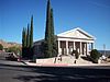 | May 14, 1986 (#86001170) | Spring and 5th Sts. 35°11′28″N 114°03′00″W / 35.191111°N 114.05°W / 35.191111; -114.05 (Saint John's Methodist Episcopal Church) | Kingman | |
| 57 | Saint Mary's Catholic Church | 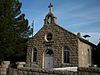 | May 14, 1986 (#86001166) | 3rd and Spring Sts. 35°11′30″N 114°03′11″W / 35.191667°N 114.053056°W / 35.191667; -114.053056 (Saint Mary's Catholic Church) | Kingman | |
| 58 | Sand Hollow Wash Bridge |  | September 30, 1988 (#88001657) | Mohave County Route 91 (Old U.S. Route 91) over Sand Hollow Wash 36°49′40″N 113°59′59″W / 36.827778°N 113.999722°W / 36.827778; -113.999722 (Sand Hollow Wash Bridge) | Littlefield | |
| 59 | Mrs. M. P. Sargent House |  | May 14, 1986 (#86001167) | 426 Topeka 35°11′14″N 114°03′04″W / 35.187222°N 114.051111°W / 35.187222; -114.051111 (Mrs. M. P. Sargent House) | Kingman | |
| 60 | Schoolhouse at Truxton Canyon Training School |  | November 21, 2003 (#03001197) | State Route 66 35°23′12″N 113°39′37″W / 35.386667°N 113.660278°W / 35.386667; -113.660278 (Schoolhouse at Truxton Canyon Training School) | Valentine | |
| 61 | G. H. Sullivan Lodging House |  | May 14, 1986 (#86001168) | 218 E. Oak 35°11′26″N 114°03′16″W / 35.190556°N 114.054444°W / 35.190556; -114.054444 (G. H. Sullivan Lodging House) | Kingman | |
| 62 | Tyrell House |  | May 14, 1986 (#86001172) | 133 Beale St. 35°11′24″N 114°03′20″W / 35.19°N 114.055556°W / 35.19; -114.055556 (Tyrell House) | Kingman | |
| 63 | US Post Office |  | May 14, 1986 (#86001173) | 310 N. 4th St. 35°11′25″N 114°03′06″W / 35.190278°N 114.051667°W / 35.190278; -114.051667 (US Post Office) | Kingman | |
| 64 | Van Marter Building |  | May 14, 1986 (#86001174) | 423-427 Beale St. 35°11′23″N 114°03′04″W / 35.189722°N 114.051111°W / 35.189722; -114.051111 (Van Marter Building) | Kingman | |
| 65 | O. E. Walker House | Upload image | May 14, 1986 (#86001175) | 906 Madison 35°11′04″N 114°02′36″W / 35.184444°N 114.043333°W / 35.184444; -114.043333 (O. E. Walker House) | Kingman | |
| 66 | Dr. Toler R. White House |  | May 14, 1986 (#86001176) | 509 Spring St. 35°11′29″N 114°02′59″W / 35.191389°N 114.049722°W / 35.191389; -114.049722 (Dr. Toler R. White House) | Kingman | |
| 67 | E. B. Williams House |  | May 14, 1986 (#86001177) | 531 E. Oak St. 35°11′26″N 114°02′59″W / 35.190556°N 114.049722°W / 35.190556; -114.049722 (E. B. Williams House) | Kingman | |
| 68 | Willow Beach Gauging Station | 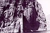 | March 21, 1986 (#86000587) | Lake Mead National Recreation Area 35°53′17″N 114°40′57″W / 35.888056°N 114.6825°W / 35.888056; -114.6825 (Willow Beach Gauging Station) | Willow Beach | |
| 69 | J. B. Wright House |  | May 14, 1986 (#86001178) | 317 Spring St. 35°11′30″N 114°03′09″W / 35.191667°N 114.0525°W / 35.191667; -114.0525 (J. B. Wright House) | Kingman | |
| 70 | Charles Ziemer House | Upload image | May 14, 1986 (#86001179) | 507 E. Oak St. 35°11′26″N 114°03′00″W / 35.190556°N 114.05°W / 35.190556; -114.05 (Charles Ziemer House) | Kingman |
See also
- List of National Historic Landmarks in Arizona
- National Register of Historic Places listings in Arizona
References
- ^ The latitude and longitude information provided in this table was derived originally from the National Register Information System, which has been found to be fairly accurate for about 99% of listings. Some locations in this table may have been corrected to current GPS standards.
- ^ National Park Service, United States Department of the Interior, "National Register of Historic Places: Weekly List Actions", retrieved June 28, 2024.
- ^ Numbers represent an alphabetical ordering by significant words. Various colorings, defined here, differentiate National Historic Landmarks and historic districts from other NRHP buildings, structures, sites or objects.
- ^ The eight-digit number below each date is the number assigned to each location in the National Register Information System database, which can be viewed by clicking the number.
External links
Map all coordinates using OpenStreetMap
Download coordinates as:
- KML
- GPX (all coordinates)
- GPX (primary coordinates)
- GPX (secondary coordinates)
![]() Media related to National Register of Historic Places in Mohave County, Arizona at Wikimedia Commons
Media related to National Register of Historic Places in Mohave County, Arizona at Wikimedia Commons
- v
- t
- e
- List of U.S. National Historic Landmarks by state:
- Alabama
- Alaska
- Arizona
- Arkansas
- California
- Colorado
- Connecticut
- Delaware
- Florida
- Georgia
- Hawaii
- Idaho
- Illinois
- Indiana
- Iowa
- Kansas
- Kentucky
- Louisiana
- Maine
- Maryland
- Massachusetts
- Michigan
- Minnesota
- Mississippi
- Missouri
- Montana
- Nebraska
- Nevada
- New Hampshire
- New Jersey
- New Mexico
- New York
- North Carolina
- North Dakota
- Ohio
- Oklahoma
- Oregon
- Pennsylvania
- Rhode Island
- South Carolina
- South Dakota
- Tennessee
- Texas
- Utah
- Vermont
- Virginia
- Washington
- West Virginia
- Wisconsin
- Wyoming
 National Register of Historic Places portal
 Category


| |||
|---|---|---|---|
 | |||
Municipalities and communities of Mohave County, Arizona, United States | ||
|---|---|---|
County seat: Kingman | ||
| Cities |  | |
| Town | ||
| CDPs |
| |
| Populated places | ||
| Indian reservations | ||
| Ghost towns | ||
| ||


