National Register of Historic Places listings in Oahu

This is a list of properties and districts on the Hawaiian island of Oahu that are listed on the National Register of Historic Places. Oahu is the only major island in Honolulu County. The location of the city of Honolulu, Oahu is the most populous island in the state. There are 169 properties and districts on the island, including 16 National Historic Landmarks. Five formerly listed sites were demolished and have been removed from the Register.
Map all coordinates using OpenStreetMap
Download coordinates as:
- KML
- GPX (all coordinates)
- GPX (primary coordinates)
- GPX (secondary coordinates)
Current listings
| [1] | Name on the Register | Image | Date listed[2] | Location | Community | Description |
|---|---|---|---|---|---|---|
| 1 | Ala Wai Villas |  | August 15, 2019 (#100004290) | 2455 Ala Wai Blvd. 21°16′40″N 157°49′17″W / 21.2777°N 157.8213°W / 21.2777; -157.8213 (Ala Wai Villas) | Honolulu | |
| 2 | Alexander and Baldwin Building | 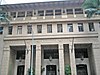 | September 7, 1979 (#79000755) | 822 Bishop St. 21°18′29″N 157°51′45″W / 21.307982°N 157.862635°W / 21.307982; -157.862635 (Alexander and Baldwin Building) | Honolulu | |
| 3 | Ali'iōlani Hale | 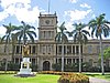 | February 2, 1972 (#72000414) | 417 S King St. 21°18′19″N 157°51′36″W / 21.305413°N 157.860136°W / 21.305413; -157.860136 (Ali'iōlani Hale) | Honolulu | |
| 4 | Aloha Tower |  | May 13, 1976 (#76000660) | Pier 9 in Honolulu Harbor 21°18′25″N 157°51′58″W / 21.307052°N 157.865994°W / 21.307052; -157.865994 (Aloha Tower) | Honolulu | |
| 5 | Barbers Point Light |  | March 26, 2024 (#100010117) | Southwest end of Olai Street, 0.1 mile west of Barbers Point Beach Park 21°15′25″N 157°48′10″W / 21.256811°N 157.802792°W / 21.256811; -157.802792 (Barbers Point Light) | Kapolei vicinity | |
| 6 | Mr. and Mrs. David Barry Jr. House |  | January 12, 2017 (#100000481) | 3625 Diamond Head Road 21°15′25″N 157°48′10″W / 21.256811°N 157.802792°W / 21.256811; -157.802792 (Mr. and Mrs. David Barry Jr. House) | Honolulu | |
| 7 | Battery Hasbrouck |  | June 5, 1984 (#84000925) | Fort Kamehameha 21°19′30″N 157°57′40″W / 21.325°N 157.961111°W / 21.325; -157.961111 (Battery Hasbrouck) | Honolulu | Site of coastal artillery in Fort Kamehameha |
| 8 | Battery Hawkins |  | June 5, 1984 (#84000928) | 440 Nelson Avenue 21°19′N 157°58′W / 21.32°N 157.96°W / 21.32; -157.96 (Battery Hawkins) | Honolulu | Site of coastal artillery in Fort Kamehameha |
| 9 | Battery Hawkins Annex |  | June 5, 1984 (#84000948) | Fort Kamehameha 21°19′N 157°58′W / 21.32°N 157.96°W / 21.32; -157.96 (Battery Hawkins Annex) | Honolulu | Site of bunker in Fort Kamehameha |
| 10 | Battery Jackson | Upload image | June 5, 1984 (#84000954) | Fort Kamehameha 21°19′06″N 157°57′22″W / 21.318333°N 157.956111°W / 21.318333; -157.956111 (Battery Jackson) | Honolulu | Site of coastal artillery in Fort Kamehameha |
| 11 | Battery Randolph | 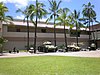 | June 5, 1984 (#84000971) | 32 Kalia Road 21°16′58″N 157°50′11″W / 21.282778°N 157.836389°W / 21.282778; -157.836389 (Battery Randolph) | Honolulu | Site of coastal artillery in Fort DeRussy, now a museum |
| 12 | Battery Selfridge | Upload image | June 5, 1984 (#84000975) | Fort Kamehameha 21°19′05″N 157°57′09″W / 21.318056°N 157.9525°W / 21.318056; -157.9525 (Battery Selfridge) | Honolulu | Site of coastal artillery in Fort Kamehameha |
| 13 | Bellows Field Archeological Area | Upload image | August 14, 1973 (#73002278) | Address Restricted | Waimanalo | |
| 14 | Bernice P. Bishop Museum |  | July 26, 1982 (#82002500) | 1355 Kalihi St. 21°20′00″N 157°52′16″W / 21.3332°N 157.871079°W / 21.3332; -157.871079 (Bernice P. Bishop Museum) | Honolulu | |
| 15 | Boettcher Estate |  | April 26, 2002 (#02000388) | 248 North Kalaheo 21°24′16″N 157°44′23″W / 21.404533°N 157.739691°W / 21.404533; -157.739691 (Boettcher Estate) | Kailua | built 1937, architect Vladimir Ossipoff |
| 16 | The Bowers' House | Upload image | April 4, 2024 (#100010159) | 4837 Sierra Drive 21°17′48″N 157°47′17″W / 21.2968°N 157.7881°W / 21.2968; -157.7881 (The Bowers' House) | Honolulu | |
| 17 | C. Brewer Building |  | April 2, 1980 (#80001272) | 827 Fort St. 21°18′30″N 157°51′47″W / 21.308362°N 157.863134°W / 21.308362; -157.863134 (C. Brewer Building) | Honolulu | |
| 18 | Burial Platform | Upload image | August 14, 1973 (#73000670) | Address Restricted | Kahuku | |
| 19 | Thomas Alexander Burningham House |  | October 13, 1993 (#93001029) | 2849 Pali Highway 21°20′07″N 157°50′25″W / 21.335229°N 157.84018°W / 21.335229; -157.84018 (Thomas Alexander Burningham House) | Honolulu | |
| 20 | Bushnell House |  | July 17, 2017 (#100000483) | 3210 Melemele Pl. 21°19′02″N 157°47′45″W / 21.317084°N 157.795768°W / 21.317084; -157.795768 (Bushnell House) | Honolulu | |
| 21 | Georges de S. Canavarro House |  | May 28, 1980 (#80001274) | 2756 Rooke Ave. 21°20′16″N 157°50′46″W / 21.33785°N 157.845997°W / 21.33785; -157.845997 (Georges de S. Canavarro House) | Honolulu | Now a Korean Cultural Center |
| 22 | Lloyd Case House |  | June 5, 1987 (#86002829) | 3581 Woodlawn Dr. 21°19′07″N 157°47′52″W / 21.318612°N 157.797807°W / 21.318612; -157.797807 (Lloyd Case House) | Honolulu | |
| 23 | Central Fire Station |  | December 2, 1980 (#80001273) | 104 S. Beretania St. 21°18′40″N 157°51′32″W / 21.311195°N 157.858989°W / 21.311195; -157.858989 (Central Fire Station) | Honolulu | renovated 1934, architects Dickey & Young |
| 24 | Central Intermediate School |  | February 11, 2004 (#03001049) | 1302 Queen Emma St. 21°18′41″N 157°51′24″W / 21.311389°N 157.856667°W / 21.311389; -157.856667 (Central Intermediate School) | Honolulu | |
| 25 | Jean Charlot House |  | November 30, 2000 (#00001371) | Address Restricted | Honolulu | |
| 26 | Chinatown Historic District |  | January 17, 1973 (#73000658) | Bounded roughly by Beretania St. on the northeast, Nuuanu Stream on the north, Nuuanu Ave. on the southeast, and Honolulu Harbor 21°18′43″N 157°51′46″W / 21.311985°N 157.862669°W / 21.311985; -157.862669 (Chinatown Historic District) | Honolulu | |
| 27 | Church of the Crossroads |  | November 20, 1992 (#92001551) | 1212 University Ave. 21°17′39″N 157°49′19″W / 21.294223°N 157.821909°W / 21.294223; -157.821909 (Church of the Crossroads) | Honolulu | |
| 28 | CINCPAC Headquarters |  | May 28, 1987 (#87001295) | Pearl Harbor Naval Base 21°22′03″N 157°56′18″W / 21.3675°N 157.938333°W / 21.3675; -157.938333 (CINCPAC Headquarters) | Pearl Harbor | |
| 29 | James L. Coke House |  | August 20, 1986 (#86001618) | 3649 Nuuanu Pali Dr. 21°20′37″N 157°49′43″W / 21.343684°N 157.82874°W / 21.343684; -157.82874 (James L. Coke House) | Honolulu | Also called Waipuna, built 1934, architects Richard Tongg and C.W. Dickey |
| 30 | Grace Cooke House |  | October 24, 1983 (#83003556) | 2365 Oahu Ave. 21°18′21″N 157°49′07″W / 21.305763°N 157.818588°W / 21.305763; -157.818588 (Grace Cooke House) | Honolulu | Bungalow style built in 1912 |
| 31 | Charles Montague Cooke Jr. House and Kuka'o'o Heiau |  | October 31, 1985 (#85003402) | 2859 Manoa Rd. 21°18′44″N 157°48′52″W / 21.312247°N 157.814562°W / 21.312247; -157.814562 (Charles Montague Cooke Jr. House and Kuka'o'o Heiau) | Honolulu | Grand Tudor Revival residence built in 1912 by architects Emory & Webb |
| 32 | Clarence H. Cooke House |  | August 20, 1986 (#86001619) | 3860 Old Pali Rd. 21°20′53″N 157°49′33″W / 21.348173°N 157.825964°W / 21.348173; -157.825964 (Clarence H. Cooke House) | Honolulu | |
| 33 | Bartlett Cooper House |  | June 5, 1987 (#86002833) | 4850 Kahala Ave. 21°16′11″N 157°46′45″W / 21.269655°N 157.779165°W / 21.269655; -157.779165 (Bartlett Cooper House) | Honolulu | |
| 34 | Cooper Apartments |  | August 7, 2017 (#100001417) | 413 Seaside Ave. 21°16′50″N 157°49′36″W / 21.280451°N 157.826651°W / 21.280451; -157.826651 (Cooper Apartments) | Honolulu | |
| 35 | Dearborn Chemical Company Warehouse |  | August 19, 2019 (#100004287) | 941 Waimanu St. 21°17′53″N 157°51′10″W / 21.2981°N 157.8529°W / 21.2981; -157.8529 (Dearborn Chemical Company Warehouse) | Honolulu | |
| 36 | C.W. Dickey House |  | November 1, 1984 (#84000201) | 3030 Kalakaua Ave. 21°15′32″N 157°49′07″W / 21.258951°N 157.818644°W / 21.258951; -157.818644 (C.W. Dickey House) | Honolulu | |
| 37 | Dilks Property |  | May 17, 2016 (#16000272) | 1302 Mokulua Dr. 21°23′11″N 157°42′42″W / 21.386418°N 157.711796°W / 21.386418; -157.711796 (Dilks Property) | Kailua | |
| 38 | Dillingham Transportation Building |  | September 7, 1979 (#79000756) | 735 Bishop St. 21°18′26″N 157°51′47″W / 21.307222°N 157.863086°W / 21.307222; -157.863086 (Dillingham Transportation Building) | Honolulu | |
| 39 | James D. Dole Homestead |  | June 23, 1978 (#78001024) | Waipahu Cultural Garden 21°23′07″N 158°00′43″W / 21.385278°N 158.011944°W / 21.385278; -158.011944 (James D. Dole Homestead) | Waipahu | 1901 house of Pineapple planter |
| 40 | Carl H. Duhrsen House |  | June 5, 1987 (#86002834) | 3029 Felix St. 21°17′46″N 157°48′26″W / 21.296109°N 157.807154°W / 21.296109; -157.807154 (Carl H. Duhrsen House) | Honolulu | |
| 41 | Ewa Plain Battlefield | Upload image | May 23, 2016 (#16000273) | Roosevelt Avenue, approximately 5.5 miles (8.9 km) southwest of Ford Island 21°19′38″N 158°02′41″W / 21.32725°N 158.044586°W / 21.32725; -158.044586 (Ewa Plain Battlefield) | Kapolei vicinity | |
| 42 | Jessie Eyman–Wilma Judson House |  | August 20, 1986 (#86001621) | 3114 Paty Dr. 21°18′36″N 157°48′03″W / 21.309939°N 157.800802°W / 21.309939; -157.800802 (Jessie Eyman–Wilma Judson House) | Honolulu | built 1926, architect C.W. Dickey |
| 43 | Dr. Robert Faus House |  | June 5, 1987 (#86002828) | 2311 Ferdinand Ave. 21°18′26″N 157°49′26″W / 21.307242°N 157.823915°W / 21.307242; -157.823915 (Dr. Robert Faus House) | Honolulu | |
| 44 | Fort Ruger Historic District |  | July 14, 1983 (#83000249) | Diamond Head Rd. 21°16′03″N 157°48′31″W / 21.2675°N 157.808611°W / 21.2675; -157.808611 (Fort Ruger Historic District) | Honolulu | |
| 45 | Foster Botanical Garden |  | May 13, 1993 (#93000377) | 50 N. Vineyard Boulevard 21°18′58″N 157°51′28″W / 21.316183°N 157.857781°W / 21.316183; -157.857781 (Foster Botanical Garden) | Honolulu | |
| 46 | Friendship Garden |  | June 7, 2016 (#15000885) | 45-226 Kokokani Pl. 21°24′17″N 157°46′37″W / 21.404759°N 157.776917°W / 21.404759; -157.776917 (Friendship Garden) | Kaneohe | |
| 47 | J. B. Guard House | Upload image | November 23, 2015 (#15000847) | 305A Portlock Rd. 21°16′33″N 157°42′31″W / 21.275959°N 157.708680°W / 21.275959; -157.708680 (J. B. Guard House) | Honolulu | |
| 48 | John Guild House |  | August 1, 1980 (#80001275) | 2001 Vancouver Dr. 21°18′03″N 157°49′21″W / 21.30084°N 157.822418°W / 21.30084; -157.822418 (John Guild House) | Honolulu | |
| 49 | Hawaii Capital Historic District |  | December 1, 1978 (#78001020) | Beretania, Richards, King, Queen, Punchbowl, and Kawaiahao Sts. 21°18′26″N 157°51′29″W / 21.307087°N 157.85798°W / 21.307087; -157.85798 (Hawaii Capital Historic District) | Honolulu | |
| 50 | Hawaii Shingon Mission |  | April 26, 2002 (#02000386) | 915 Sheridan St. 21°17′52″N 157°50′27″W / 21.297817°N 157.840963°W / 21.297817; -157.840963 (Hawaii Shingon Mission) | Honolulu | |
| 51 | Hawaii Theatre |  | November 14, 1978 (#78001021) | 1130 Bethel St. 21°18′40″N 157°51′40″W / 21.311018°N 157.861243°W / 21.311018; -157.861243 (Hawaii Theatre) | Honolulu | |
| 52 | Heʻeia Fishpond |  | January 17, 1973 (#73000671) | Address Restricted | Kaneohe | |
| 53 | Edgar and Lucy Henriques House |  | November 1, 1984 (#84000202) | 20 Old Pali Pl. 21°20′48″N 157°49′36″W / 21.346782°N 157.826648°W / 21.346782; -157.826648 (Edgar and Lucy Henriques House) | Honolulu | |
| 54 | Hickam Field |  | September 16, 1985 (#85002725) | Southeast of Pearl Harbor Naval Base 21°20′07″N 157°56′54″W / 21.335278°N 157.948333°W / 21.335278; -157.948333 (Hickam Field) | Honolulu | |
| 55 | Alfred Hocking House |  | November 15, 1984 (#84000246) | 1302 Nehoa St. 21°18′32″N 157°50′05″W / 21.308942°N 157.834767°W / 21.308942; -157.834767 (Alfred Hocking House) | Honolulu | Built 1903, designed by E.A.P. Newcomb and C.W. Dickey in Queen Anne style architecture |
| 56 | Lemon Wond Holt House |  | May 24, 2006 (#06000422) | 3704 Anuhea St. 21°17′11″N 157°47′42″W / 21.286318°N 157.795054°W / 21.286318; -157.795054 (Lemon Wond Holt House) | Honolulu | |
| 57 | Honouliuli Internment Camp |  | February 21, 2012 (#09000855) | Address Restricted | Waipahu vicinity | |
| 58 | Honolulu Academy of Arts |  | March 25, 1972 (#72000415) | 900 S. Beretania St. 21°18′15″N 157°50′55″W / 21.304109°N 157.848634°W / 21.304109; -157.848634 (Honolulu Academy of Arts) | Honolulu | |
| 59 | House at 3023 Kalakaua Avenue |  | June 5, 1987 (#86002820) | 3023 Kalakaua Ave. 21°15′33″N 157°49′08″W / 21.259108°N 157.819019°W / 21.259108; -157.819019 (House at 3023 Kalakaua Avenue) | Honolulu | Built 1932 by Earl Williams |
| 60 | House at 3023A Kalakaua Avenue |  | June 5, 1987 (#86002821) | 3023A Kalakaua Ave. 21°15′33″N 157°49′09″W / 21.259063°N 157.819111°W / 21.259063; -157.819111 (House at 3023A Kalakaua Avenue) | Honolulu | Built 1932 by Earl Williams |
| 61 | House at 3023B Kalakaua Avenue |  | June 5, 1987 (#86002822) | 3023B Kalakaua Ave. 21°15′33″N 157°49′09″W / 21.259028°N 157.819226°W / 21.259028; -157.819226 (House at 3023B Kalakaua Avenue) | Honolulu | Built 1932 by Earl Williams |
| 62 | House at 3027 Kalakaua Avenue |  | June 5, 1987 (#86002826) | 3027 Kalakaua Ave. 21°15′32″N 157°49′08″W / 21.258991°N 157.818958°W / 21.258991; -157.818958 (House at 3027 Kalakaua Avenue) | Honolulu | Built 1932 by Earl Williams |
| 63 | House at 3033 Kalakaua Avenue |  | June 5, 1987 (#86002827) | 3033 Kalakaua Ave. 21°15′32″N 157°49′09″W / 21.258956°N 157.819063°W / 21.258956; -157.819063 (House at 3033 Kalakaua Avenue) | Honolulu | Built 1932 by Earl Williams |
| 64 | House at 3033B Kalakaua Avenue |  | June 5, 1987 (#86002825) | 3033B Kalakaua Ave. 21°15′32″N 157°49′09″W / 21.258919°N 157.819191°W / 21.258919; -157.819191 (House at 3033B Kalakaua Avenue) | Honolulu | Built 1932 by Earl Williams |
| 65 | House at 4109 Black Point Road | Upload image | June 5, 1987 (#86002836) | 4109 Black Point Rd. 21°15′28″N 157°47′31″W / 21.257676°N 157.791929°W / 21.257676; -157.791929 (House at 4109 Black Point Road) | Honolulu | |
| 66 | Huilua Fishpond |  | October 15, 1966 (#66000295) | In Kahana Bay, 13 miles north of Kaneohe on Hawaii Route 83 adjacent to Ahupuaʻa O Kahana State Park 21°33′28″N 157°52′06″W / 21.557659°N 157.868441°W / 21.557659; -157.868441 (Huilua Fishpond) | Kaneohe | |
| 67 | Iolani Palace |  | October 15, 1966 (#66000293) | 364 S. King St. 21°18′24″N 157°51′32″W / 21.306728°N 157.858795°W / 21.306728; -157.858795 (Iolani Palace) | Honolulu | |
| 68 | Kahaluu Fish Pond |  | March 14, 1973 (#73000668) | Northwest of Laenani St. off Kamehameha Highway 21°27′34″N 157°50′10″W / 21.459339°N 157.836138°W / 21.459339; -157.836138 (Kahaluu Fish Pond) | Kahaluu | Private property |
| 69 | Kahaluu Taro Lo'i |  | March 14, 1973 (#73000669) | West of the western end of Hui Kelu St. 21°25′57″N 157°50′36″W / 21.4325°N 157.843333°W / 21.4325; -157.843333 (Kahaluu Taro Lo'i) | Kahaluu | Camouflaged trail access beside Ahuimanu Stream between Heno Pl. and Lile Pl. on mountain side of Hui Kelu St. |
| 70 | Kahuku Habitation Area | Upload image | September 11, 1972 (#72000424) | Address Restricted | Kahuku | |
| 71 | Kaimuki Fire Station |  | December 2, 1980 (#80001276) | 971 Koko Head Ave. 21°16′42″N 157°47′58″W / 21.278428°N 157.79933°W / 21.278428; -157.79933 (Kaimuki Fire Station) | Honolulu | built 1924, architect G. Robert Miller |
| 72 | Henry J. and Alyce Kaiser Estate | Upload image | August 16, 2019 (#100004289) | 525 Portlock Rd. 21°16′06″N 157°42′29″W / 21.2682°N 157.7080°W / 21.2682; -157.7080 (Henry J. and Alyce Kaiser Estate) | Honolulu | |
| 73 | Kakaako Fire Station |  | December 2, 1980 (#80001277) | 620 South St. 21°18′09″N 157°51′34″W / 21.302439°N 157.85931°W / 21.302439; -157.85931 (Kakaako Fire Station) | Honolulu | built 1929, architect Solomon F. Kenn |
| 74 | Kakaako Pumping Station |  | October 4, 1978 (#78001022) | 653 Ala Moana Boulevard 21°17′54″N 157°51′46″W / 21.298251°N 157.862796°W / 21.298251; -157.862796 (Kakaako Pumping Station) | Honolulu | |
| 75 | Kalihi Fire Station |  | December 2, 1980 (#80001278) | 1742 N. King St. 21°19′53″N 157°52′33″W / 21.331517°N 157.875934°W / 21.331517; -157.875934 (Kalihi Fire Station) | Honolulu | built 1924, architect G. Robert Miller |
| 76 | Kamehameha V Post Office |  | May 5, 1972 (#72000416) | Corner of Merchant and Bethel Sts. 21°18′35″N 157°51′47″W / 21.309639°N 157.863113°W / 21.309639; -157.863113 (Kamehameha V Post Office) | Honolulu | |
| 77 | Kaneohe Naval Air Station |  | May 28, 1987 (#87001299) | Area between 1st St. and Kāne'ohe Bay 21°26′45″N 157°46′11″W / 21.445833°N 157.769722°W / 21.445833; -157.769722 (Kaneohe Naval Air Station) | Kailua | |
| 78 | Kaneohe Ranch Building |  | June 5, 1987 (#87001150) | Castle junction 21°22′30″N 157°46′49″W / 21.375001°N 157.780378°W / 21.375001; -157.780378 (Kaneohe Ranch Building) | Kailua | |
| 79 | Kaniakapupu |  | October 15, 1986 (#86002805) | Address Restricted | Nuuanu | Ruins of the summer palace of King Kamehameha III |
| 80 | Kapapa Island Complex | Upload image | August 21, 1972 (#72000430) | Address Restricted | Kapapa Island | |
| 81 | Kapuaiwa Building |  | July 2, 1973 (#73000660) | 426 Queen St. 21°18′17″N 157°51′36″W / 21.304723°N 157.859969°W / 21.304723; -157.859969 (Kapuaiwa Building) | Honolulu | Built 1884, architect George Lucas |
| 82 | Kaumakapili Church |  | May 5, 2008 (#08000372) | 766 N. King St. 21°19′18″N 157°51′59″W / 21.32171°N 157.866516°W / 21.32171; -157.866516 (Kaumakapili Church) | Honolulu | |
| 83 | Kawaewae Heiau |  | August 21, 1972 (#72000427) | On hill above dead end of Lipalu Street[3] 21°23′43″N 157°47′08″W / 21.395222°N 157.785556°W / 21.395222; -157.785556 (Kawaewae Heiau) | Kaneohe | |
| 84 | Kawaiahao Church and Mission Houses |  | October 15, 1966 (#66000294) | 957 Punchbowl St., 553 S. King St. 21°18′16″N 157°51′28″W / 21.304364°N 157.857829°W / 21.304364; -157.857829 (Kawaiahao Church and Mission Houses) | Honolulu | |
| 85 | Kawailoa Ryusenji Temple |  | November 21, 1978 (#78001019) | North of Haleiwa at 179-A Kawailoa Dr. 21°36′37″N 158°05′02″W / 21.610278°N 158.083889°W / 21.610278; -158.083889 (Kawailoa Ryusenji Temple) | Haleiwa | Demolished.[4] Congregation and some religious symbols relocated to Wahiawa Ryūsenji Sōtō Mission.[5] |
| 86 | Kea'au Talus Sites Archeological District | Upload image | May 4, 1987 (#86002808) | Address Restricted | Waianae | |
| 87 | Keaiwa Heiau |  | November 9, 1972 (#72000413) | At top of Aiea Heights Dr. 21°24′01″N 157°54′26″W / 21.400278°N 157.907222°W / 21.400278; -157.907222 (Keaiwa Heiau) | Aiea | Temple site with many plants used for healing |
| 88 | John and Kate Kelly House |  | August 27, 1991 (#91001085) | 4117 Blackpoint Rd. 21°15′23″N 157°47′32″W / 21.256294°N 157.792345°W / 21.256294; -157.792345 (John and Kate Kelly House) | Honolulu | |
| 89 | Kualoa Ahupua'a Historical District |  | October 16, 1974 (#74000718) | Kamehameha Highway 21°31′29″N 157°50′39″W / 21.524722°N 157.844167°W / 21.524722; -157.844167 (Kualoa Ahupua'a Historical District) | Kaneohe | |
| 90 | Kukaniloko Birth Site |  | April 11, 1973 (#73000674) | At corner of Kamehameha Highway and Whitmore Ave. 21°30′17″N 158°02′10″W / 21.504725°N 158.036218°W / 21.504725; -158.036218 (Kukaniloko Birth Site) | Wahiawa | |
| 91 | Kukuipilau Heiau | Upload image | November 16, 1984 (#84000254) | On grounds of Hawaiʻi Youth Correctional Facility off Kalanianaʻole Highway 21°22′36″N 157°44′56″W / 21.3766°N 157.748825°W / 21.3766; -157.748825 (Kukuipilau Heiau) | Kailua | In gulch below buildings of Hawaiʻi Youth Correctional Facility[6] |
| 92 | Kunia Camp | Upload image | December 1, 2014 (#14000970) | Roughly bounded by Kunia & Pu'u Drives 21°27′44″N 158°03′33″W / 21.4623°N 158.0592°W / 21.4623; -158.0592 (Kunia Camp) | Kunia | |
| 93 | Kupopolo Heiau | Upload image | June 4, 1973 (#73000657) | Address Restricted | Haleiwa | |
| 94 | Kyoto Gardens of Honolulu Memorial Park |  | February 11, 2004 (#04000020) | 22 Craigside Place 21°19′21″N 157°50′51″W / 21.322422°N 157.847625°W / 21.322422; -157.847625 (Kyoto Gardens of Honolulu Memorial Park) | Honolulu | |
| 95 | Leleahina Heiau | Upload image | March 20, 1973 (#73000672) | South of Haiku Plantation Dr. 21°25′28″N 157°49′37″W / 21.424444°N 157.826944°W / 21.424444; -157.826944 (Leleahina Heiau) | Kaneohe | |
| 96 | Lihiwai |  | July 26, 1982 (#82002501) | 51 Kepola Pl.; also 41C Kepola Pl. 21°20′29″N 157°49′54″W / 21.341345°N 157.831664°W / 21.341345; -157.831664 (Lihiwai) | Honolulu | 41C Kepola represents a boundary increase of 0 |
| 97 | Liljestrand House |  | March 26, 2008 (#08000207) | 3300 Tantalus Dr. 21°19′27″N 157°49′52″W / 21.324284°N 157.83112°W / 21.324284; -157.83112 (Liljestrand House) | Honolulu | built 1952, architect Vladimir Ossipoff, featured in House Beautiful magazine as a Pace Setter House in 1958. |
| 98 | Linekona School |  | May 28, 1980 (#80001279) | Victoria and Beretania Sts. 21°18′10″N 157°50′52″W / 21.302748°N 157.847835°W / 21.302748; -157.847835 (Linekona School) | Honolulu | |
| 99 | R.N. Linn House |  | August 20, 1986 (#86001622) | 2013 Kakela Dr. 21°18′13″N 157°49′29″W / 21.303679°N 157.824607°W / 21.303679; -157.824607 (R.N. Linn House) | Honolulu | |
| 100 | Little Makalapa Naval Housing Historic District |  | May 5, 2017 (#100000731) | Palmyra St. & Tarawa Dr. 21°21′06″N 157°56′04″W / 21.351805°N 157.934463°W / 21.351805; -157.934463 (Little Makalapa Naval Housing Historic District) | Honolulu | |
| 101 | Makalapa Naval Housing Historic District | Upload image | May 5, 2017 (#100000732) | Roughly bounded by HI1, Kamehameha Hwy., Radford & Makalapa Drs. 21°21′19″N 157°56′04″W / 21.355322°N 157.93444°W / 21.355322; -157.93444 (Makalapa Naval Housing Historic District) | Honolulu | |
| 102 | Makiki Fire Station |  | December 2, 1980 (#80001280) | 1202 Wilder Ave. 21°18′24″N 157°50′21″W / 21.306642°N 157.839032°W / 21.306642; -157.839032 (Makiki Fire Station) | Honolulu | built 1929, architect Solomon F. Kenn |
| 103 | MALIA (Hawaiian canoe) |  | December 17, 1993 (#93001385) | Southeastern corner of the junction of Kapiolani Boulevard and McCully St. 21°17′18″N 157°49′54″W / 21.288275°N 157.831789°W / 21.288275; -157.831789 (MALIA (Hawaiian canoe)) | Honolulu | Wooden dugout-style Hawaiian canoe built in 1933 by James Takeo Yamasaki |
| 104 | Marconi Wireless Telegraphy Station |  | June 4, 2013 (#13000352) | 56-1095 Kamehameha Hwy. 21°42′26″N 157°58′23″W / 21.707222°N 157.973139°W / 21.707222; -157.973139 (Marconi Wireless Telegraphy Station) | Kahuku | |
| 105 | Marigold Building |  | August 18, 1983 (#83000250) | 94-837 Waipahu St. 21°23′07″N 158°00′29″W / 21.385239°N 158.007987°W / 21.385239; -158.007987 (Marigold Building) | Waipahu | Original building https://npgallery.nps.gov/NRHP/GetAsset/NRHP/83000250_photos replaced by Leeward Oahu Pharmacy |
| 106 | McKinley High School |  | August 11, 1980 (#80001281) | 1039 S. King St. 21°17′57″N 157°50′54″W / 21.29909°N 157.848221°W / 21.29909; -157.848221 (McKinley High School) | Honolulu | Designed by Louis Davis |
| 107 | J.P. Mendonca House |  | October 7, 1986 (#86002798) | 1942 Judd Hillside Rd. 21°18′25″N 157°49′33″W / 21.307071°N 157.82578°W / 21.307071; -157.82578 (J.P. Mendonca House) | Honolulu | |
| 108 | Merchant Street Historic District |  | June 19, 1973 (#73000661) | Along Merchant St. from Nuuanu Ave. through Fort St. 21°18′35″N 157°51′48″W / 21.309671°N 157.86337°W / 21.309671; -157.86337 (Merchant Street Historic District) | Honolulu | |
| 109 | Moana Hotel |  | August 7, 1972 (#72000417) | 2365 Kalakaua Ave. 21°16′36″N 157°49′36″W / 21.276583°N 157.826656°W / 21.276583; -157.826656 (Moana Hotel) | Honolulu | |
| 110 | Moiliʻili Japanese Cemetery |  | April 7, 2015 (#15000128) | 2624 Kapiolani Boulevard 21°17′18″N 157°49′14″W / 21.288466°N 157.820522°W / 21.288466; -157.820522 (Moiliʻili Japanese Cemetery) | Honolulu | |
| 111 | Mokapu Burial Area | Upload image | November 15, 1972 (#72000428) | Address Restricted | Kaneohe | |
| 112 | Molii Fishpond |  | December 5, 1972 (#72000429) | Southeast of Kamehameha Highway between Kualoa and Johnson Rds. 21°30′35″N 157°50′46″W / 21.509755°N 157.846245°W / 21.509755; -157.846245 (Molii Fishpond) | Kaneohe | |
| 113 | National Memorial Cemetery of the Pacific |  | January 11, 1976 (#76002276) | 2177 Puowaina Dr. 21°18′46″N 157°50′46″W / 21.312725°N 157.846245°W / 21.312725; -157.846245 (National Memorial Cemetery of the Pacific) | Honolulu | |
| 114 | Naval Aviation Supply Depot Personnel Camp Quonset Hut 33 | Upload image | February 10, 2023 (#100008051) | 955 Kamehameha Hwy. (TMK 9-7-023:0) 21°23′36″N 157°58′26″W / 21.3934°N 157.9739°W / 21.3934; -157.9739 (Naval Aviation Supply Depot Personnel Camp Quonset Hut 33) | Pearl City | |
| 115 | Nuuanu Petroglyph Complex | Upload image | March 14, 1973 (#73000662) | Address Restricted | Honolulu | |
| 116 | Oahu Railway and Land Company Right-of-Way |  | December 1, 1975 (#75000621) | Barbers Point 21°20′49″N 158°01′38″W / 21.346844°N 158.027176°W / 21.346844; -158.027176 (Oahu Railway and Land Company Right-of-Way) | Nanakuli | also see Oahu Railway and Land Company |
| 117 | George D. Oakley House |  | November 15, 1984 (#84000249) | 2110 Kakela Pl. 21°18′17″N 157°49′29″W / 21.304604°N 157.824645°W / 21.304604; -157.824645 (George D. Oakley House) | Honolulu | Tudor cottage |
| 118 | Frederick Ohrt House |  | June 5, 1987 (#86002835) | 2958 Pali Highway 21°20′13″N 157°50′21″W / 21.336871°N 157.839118°W / 21.336871; -157.839118 (Frederick Ohrt House) | Honolulu | |
| 119 | Okiokilepe Pond |  | March 14, 1973 (#73000673) | 0.3 miles northwest of Iroquois Point at the entrance to Pearl Harbor 21°20′21″N 157°58′32″W / 21.339109°N 157.975466°W / 21.339109; -157.975466 (Okiokilepe Pond) | Pearl Harbor | |
| 120 | Opana Radar Site |  | September 19, 1991 (#91001379) | Off Kamehameha Highway, south of Kawela Bay 21°41′08″N 158°00′35″W / 21.685485°N 158.009666°W / 21.685485; -158.009666 (Opana Radar Site) | Kawela Bay | |
| 121 | Our Lady of Peace Cathedral |  | August 7, 1972 (#72000418) | 1183 Bishop St. 21°18′39″N 157°51′34″W / 21.310745°N 157.859414°W / 21.310745; -157.859414 (Our Lady of Peace Cathedral) | Honolulu | |
| 122 | Pahukini Heiau |  | September 11, 1972 (#72000426) | Southwest of Kapaa Quarry 21°23′41″N 157°46′11″W / 21.394722°N 157.769722°W / 21.394722; -157.769722 (Pahukini Heiau) | Kailua | |
| 123 | Palama Fire Station |  | April 21, 1976 (#76000661) | 879 N. King St. 21°19′21″N 157°52′04″W / 21.32238°N 157.867775°W / 21.32238; -157.867775 (Palama Fire Station) | Honolulu | built 1901, architect Oliver G. Traphagen |
| 124 | Palm Circle Historic District |  | October 26, 1984 (#84000104) | Roughly bounded by Carter Dr., Richardson and Funston Rds., and A and B Sts. 21°20′44″N 157°53′17″W / 21.345545°N 157.887956°W / 21.345545; -157.887956 (Palm Circle Historic District) | Honolulu | |
| 125 | Pearl Harbor, US Naval Base |  | October 15, 1966 (#66000940) | 3 miles south of Pearl City on Hawaii Route 73 21°21′09″N 157°57′20″W / 21.35258°N 157.955614°W / 21.35258; -157.955614 (Pearl Harbor, US Naval Base) | Pearl City | |
| 126 | Joseph W. Podmore Building |  | March 24, 1983 (#83000251) | 202-206 Merchant St. 21°18′27″N 157°51′41″W / 21.307382°N 157.861313°W / 21.307382; -157.861313 (Joseph W. Podmore Building) | Honolulu | built 1902, architect Lee Wai |
| 127 | Pohaku ka luahine | Upload image | July 23, 1973 (#73002273) | Address Restricted | Kaneohe | |
| 128 | Punahou School Campus |  | August 7, 1972 (#72000419) | 1601 Punahou St. 21°18′14″N 157°49′49″W / 21.303929°N 157.83032°W / 21.303929; -157.83032 (Punahou School Campus) | Honolulu | |
| 129 | Puu o Mahuka Heiau | 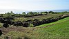 | October 15, 1966 (#66000292) | 4 miles northeast of Haleiwa on Hawaii Route 83, overlooking Waimea Bay 21°38′29″N 158°03′33″W / 21.641446°N 158.059037°W / 21.641446; -158.059037 (Puu o Mahuka Heiau) | Haleiwa | |
| 130 | Queen Emma's Summer Home |  | August 7, 1972 (#72000420) | 2913 Pali Highway 21°20′09″N 157°50′21″W / 21.335902°N 157.839119°W / 21.335902; -157.839119 (Queen Emma's Summer Home) | Honolulu | |
| 131 | Royal Brewery |  | November 29, 1972 (#72000421) | 553 S. Queen St. 21°18′11″N 157°51′33″W / 21.303139°N 157.85903°W / 21.303139; -157.85903 (Royal Brewery) | Honolulu | |
| 132 | Royal Mausoleum |  | August 7, 1972 (#72000422) | 2261 Nuuanu Ave. 21°19′30″N 157°50′50″W / 21.325°N 157.847222°W / 21.325; -157.847222 (Royal Mausoleum) | Honolulu | burial site of royal family known as Mauna ʻAla bilt in 1863 |
| 133 | Sacred Heart Church | 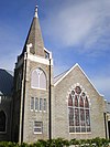 | February 6, 2001 (#89001875) | 1701 Wilder Ave. 21°18′06″N 157°49′52″W / 21.301617°N 157.831001°W / 21.301617; -157.831001 (Sacred Heart Church) | Honolulu | |
| 134 | Salvation Army Waioli Tea Room | 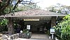 | October 30, 1998 (#98001288) | 3016 Oahu Ave. 21°18′58″N 157°48′47″W / 21.316048°N 157.813052°W / 21.316048; -157.813052 (Salvation Army Waioli Tea Room) | Honolulu | built 1926, architects Emory & Webb, founded as a girls home and bakery |
| 135 | Schofield Barracks Historic District | Upload image | July 31, 1998 (#98000889) | Roughly bounded by Foote Ave., Wright Ave., McMahon Rd., and Wright-Smith Rd. 21°29′52″N 158°03′30″W / 21.497778°N 158.058333°W / 21.497778; -158.058333 (Schofield Barracks Historic District) | Schofield Barracks | |
| 136 | Schofield Barracks Stockade | Upload image | August 24, 1998 (#98000974) | Lyman Rd. 21°29′12″N 158°03′19″W / 21.486667°N 158.055278°W / 21.486667; -158.055278 (Schofield Barracks Stockade) | Schofield Barracks | |
| 137 | J. Alvin Shadinger House |  | June 5, 1987 (#86002832) | 4584 Kahala Ave. 21°15′50″N 157°47′05″W / 21.263961°N 157.784669°W / 21.263961; -157.784669 (J. Alvin Shadinger House) | Honolulu | also known as The Gingerbread House |
| 138 | Charles A. Simpson House |  | June 5, 1987 (#86002831) | 4354 Kahala Ave. 21°15′38″N 157°47′31″W / 21.260506°N 157.791819°W / 21.260506; -157.791819 (Charles A. Simpson House) | Honolulu | |
| 139 | Dr. Archibald Neil Sinclair House |  | October 13, 1983 (#83003557) | 2726 Hillside Ave. 21°18′36″N 157°48′58″W / 21.309936°N 157.81604°W / 21.309936; -157.81604 (Dr. Archibald Neil Sinclair House) | Honolulu | built 1917, architects Emory & Webb, Colonial Revival style |
| 140 | Small Heiau | Upload image | March 14, 1973 (#73000667) | 1 mile south of Kaaawa off Kaaawa Valley Rd. 21°32′32″N 157°51′21″W / 21.542222°N 157.855833°W / 21.542222; -157.855833 (Small Heiau) | Kaaawa | |
| 141 | Mabel Smyth Memorial Building |  | February 3, 1994 (#93001558) | 510 South Beretania St. 21°18′25″N 157°51′19″W / 21.306883°N 157.855163°W / 21.306883; -157.855163 (Mabel Smyth Memorial Building) | Honolulu | built 1941, architect C.W. Dickey, renovated 1999[7] |
| 142 | St. Andrew's Cathedral | 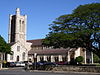 | July 2, 1973 (#73000663) | Beretania St. (Queen Emma Sq.) 21°18′35″N 157°51′26″W / 21.309849°N 157.857193°W / 21.309849; -157.857193 (St. Andrew's Cathedral) | Honolulu | |
| 143 | Tantalus-Round Top Road |  | August 14, 2009 (#08000373) | Tantalus Dr., Round Top Dr. 21°19′48″N 157°48′51″W / 21.330006°N 157.8143°W / 21.330006; -157.8143 (Tantalus-Round Top Road) | Honolulu | |
| 144 | Frank Tavares House |  | June 5, 1987 (#86002830) | 2826 Coconut Ave. 21°15′31″N 157°49′04″W / 21.258726°N 157.817815°W / 21.258726; -157.817815 (Frank Tavares House) | Honolulu | |
| 145 | Thomas Square | 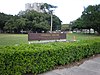 | April 25, 1972 (#72000423) | Bounded by King, S. Beretania, and Victoria Sts. and Ward Ave. 21°18′10″N 157°50′57″W / 21.302749°N 157.849037°W / 21.302749; -157.849037 (Thomas Square) | Honolulu | |
| 146 | US Coast Guard Diamond Head Lighthouse |  | October 31, 1980 (#80001282) | 3399 Diamond Head Rd. 21°15′20″N 157°48′34″W / 21.25568°N 157.809492°W / 21.25568; -157.809492 (US Coast Guard Diamond Head Lighthouse) | Honolulu | |
| 147 | US Coast Guard Makapuu Point Light |  | December 7, 1977 (#77000447) | Southeast of Waimanalo off the Kalanianaole Highway 21°18′35″N 157°38′59″W / 21.309861°N 157.649743°W / 21.309861; -157.649743 (US Coast Guard Makapuu Point Light) | Waimanalo | |
| 148 | US Immigration Office |  | August 14, 1973 (#73000664) | 595 Ala Moana Boulevard 21°17′59″N 157°51′50″W / 21.299722°N 157.863889°W / 21.299722; -157.863889 (US Immigration Office) | Honolulu | |
| 149 | US Post Office, Customhouse, and Courthouse |  | January 27, 1975 (#75000620) | 335 Merchant St. 21°18′22″N 157°51′38″W / 21.306158°N 157.860635°W / 21.306158; -157.860635 (US Post Office, Customhouse, and Courthouse) | Honolulu | |
| 150 | Ukanipo Heiau | Upload image | August 13, 1982 (#82002502) | Address Restricted | Makaha | |
| 151 | Ulu Po Heiau |  | November 9, 1972 (#72000425) | Off Route 61 northeast of the Castle Medical Center[8] 21°23′08″N 157°45′10″W / 21.385636°N 157.752876°W / 21.385636; -157.752876 (Ulu Po Heiau) | Kailua | |
| 152 | USS Arizona Memorial |  | October 15, 1966 (#66000944) | 3 miles south of Pearl City on Hawaii Route 73 21°21′53″N 157°57′00″W / 21.36485°N 157.949969°W / 21.36485; -157.949969 (USS Arizona Memorial) | Pearl City | |
| 153 | USS Arizona Wreck | 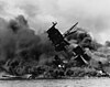 | May 5, 1989 (#89001083) | Off Ford Island in Pearl Harbor 21°21′53″N 157°57′01″W / 21.36475°N 157.950194°W / 21.36475; -157.950194 (USS Arizona Wreck) | Pearl City | |
| 154 | USS Bowfin |  | November 16, 1982 (#82000149) | 11 Arizona Memorial Dr. 21°22′07″N 157°56′22″W / 21.368611°N 157.939444°W / 21.368611; -157.939444 (USS Bowfin) | Honolulu | a submarine |
| 155 | USS Missouri |  | May 14, 1971 (#71000877) | 63 Cowpens St. 21°21′43″N 157°57′13″W / 21.361944°N 157.953611°W / 21.361944; -157.953611 (USS Missouri) | Honolulu | Moved from Bremerton, Washington and opened as a museum ship in 1999[9] |
| 156 | USS Utah Wreck | 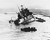 | May 5, 1989 (#89001084) | Off Ford Island in Pearl Harbor 21°22′08″N 157°57′45″W / 21.368976°N 157.962494°W / 21.368976; -157.962494 (USS Utah Wreck) | Honolulu | |
| 157 | Ernest Shelton Van Tassel House |  | December 16, 1981 (#81000203) | 3280 Round Top Dr. 21°18′54″N 157°49′15″W / 21.315031°N 157.820844°W / 21.315031; -157.820844 (Ernest Shelton Van Tassel House) | Honolulu | Former macadamia nut plantation, also called Nutridge, built 1922, architect Hart Wood |
| 158 | Waialua Agricultural Company Engine No. 6 | Upload image | August 19, 1974 (#74000719) | Off Hawaii Route 78 21°19′56″N 158°02′47″W / 21.33215°N 158.046457°W / 21.33215; -158.046457 (Waialua Agricultural Company Engine No. 6) | Lualualei | Now at the Hawaiian Railway Society.[10] |
| 159 | Waialua Fire Station |  | December 2, 1980 (#80001270) | 66-420 Haleiwa Rd. 21°35′12″N 158°06′43″W / 21.586561°N 158.111965°W / 21.586561; -158.111965 (Waialua Fire Station) | Haleiwa | built 1932, architect A.W. Heen |
| 160 | Waialua School |  | August 11, 1980 (#80001271) | 66-505 Haleiwa Rd. 21°35′05″N 158°06′49″W / 21.58484°N 158.113658°W / 21.58484; -158.113658 (Waialua School) | Haleiwa | |
| 161 | Waianae District | Upload image | January 21, 1974 (#74000720) | Address Restricted | Waianae | |
| 162 | Waikane Taro Flats | Upload image | April 11, 1973 (#73000675) | 1 mile northwest of Waikane in Upper Waikane Valley 21°30′16″N 157°52′39″W / 21.504444°N 157.8775°W / 21.504444; -157.8775 (Waikane Taro Flats) | North Ko'olaupoko | |
| 163 | Waimalu Shopping Center |  | April 8, 2021 (#100006350) | 98-020 Kamehameha Hwy. 21°23′08″N 157°57′00″W / 21.3855°N 157.9500°W / 21.3855; -157.9500 (Waimalu Shopping Center) | Waimalu | |
| 164 | Wakamiya Inari Shrine |  | January 8, 1980 (#80001285) | Waipahu Cultural Garden 21°23′29″N 158°00′58″W / 21.3914°N 158.0161°W / 21.3914; -158.0161 (Wakamiya Inari Shrine) | Waipahu | |
| 165 | H. Alexander Walker Residence |  | April 24, 1973 (#73000665) | 2616 Pali Highway 21°19′55″N 157°50′38″W / 21.3320°N 157.8438°W / 21.3320; -157.8438 (H. Alexander Walker Residence) | Honolulu | |
| 166 | War Memorial Natatorium |  | August 11, 1980 (#80001283) | Kalakaua Ave. 21°15′52″N 157°49′20″W / 21.2645°N 157.8222°W / 21.2645; -157.8222 (War Memorial Natatorium) | Honolulu | |
| 167 | George R. Ward House |  | February 23, 2016 (#16000029) | 2438 Ferdinand Ave. 21°18′32″N 157°49′21″W / 21.3088°N 157.8224°W / 21.3088; -157.8224 (George R. Ward House) | Honolulu | |
| 168 | Washington Place |  | June 18, 1973 (#73000666) | 320 Beretania St. 21°18′32″N 157°51′24″W / 21.3088°N 157.8567°W / 21.3088; -157.8567 (Washington Place) | Honolulu | |
| 169 | Wheeler Field |  | May 28, 1987 (#87001297) | Area around Wright Ave. and the flight line 21°28′53″N 158°02′15″W / 21.4815°N 158.0376°W / 21.4815; -158.0376 (Wheeler Field) | Schofield Barracks |
Former listings
| [1] | Name on the Register | Image | Date listed | Date removed | Location | City or town | Description |
|---|---|---|---|---|---|---|---|
| 1 | Aiea Sugar Mill |  | January 11, 1996 (#95001501) | October 14, 2009 | 99-197 Aiea Heights Dr. 21°23′05″N 157°55′43″W / 21.3847°N 157.9286°W / 21.3847; -157.9286 (Aiea Sugar Mill) | Aiea | Demolished in 1998[11][12] |
| 2 | FALLS OF CLYDE |  | July 2, 1973 (#73000659) | February 1, 2024 | Pier 7 in Honolulu Harbor 21°18′21″N 157°51′54″W / 21.305718°N 157.865029°W / 21.305718; -157.865029 (FALLS OF CLYDE) | Honolulu | Only surviving iron-hulled, four-masted full-rigged ship, and only surviving sail-driven oil tanker in the world. |
| 3 | Katsuki House | Upload image | March 26, 1976 (#76002275) | 1978 | 1326 Keeaumoku St. | Honolulu | Queen Ann "gingerbread"-style house owned by the Katsuki family, destroyed by fire May 6, 1978[13] |
| 4 | Lishman Building | Upload image | September 13, 1978 (#78001023) | October 28, 2012 | Makiki Park, Keeaumoku St. 21°18′29″N 157°50′22″W / 21.308056°N 157.839444°W / 21.308056; -157.839444 (Lishman Building) | Honolulu | Demolished[14] |
| 5 | Alexander Young Building | Upload image | August 5, 1980 (#80001284) | October 14, 2009 | Bishop St. 21°18′48″N 157°51′48″W / 21.3133°N 157.8633°W / 21.3133; -157.8633 (Alexander Young Building) | Honolulu | Demolished in 1981[15] |
See also
- List of National Historic Landmarks in Hawaii
- National Register of Historic Places listings in Hawaii
References
- ^ a b Numbers represent an alphabetical ordering by significant words. Various colorings, defined here, differentiate National Historic Landmarks and historic districts from other NRHP buildings, structures, sites or objects.
- ^ The eight-digit number below each date is the number assigned to each location in the National Register Information System database, which can be viewed by clicking the number.
- ^ "Protecting Kaneohe from Hawaiian Memorial Expansion: Proposed Development". Hui O' Pikoiloa / SaveKaneohe.org. Archived from the original on July 27, 2011. Retrieved February 15, 2010.
- ^ Clark, John R. K. (2007). Guardian of the sea: Jizo in Hawai'i. Honolulu: University of Hawai‘i Press. p. 76. ISBN 9780824831585.
- ^ Tanabe, George J.; Tanabe, Willa Jane (2013). Japanese Buddhist Temples in Hawai'i: An Illustrated Guide. Honolulu: University of Hawai‘i Press. pp. 102–103. ISBN 978-0-8248-3679-5.
- ^ Hamasaki, Mark; Landgraf, Kapuani (2009). Kailua. Kailua Historical Society. pp. 127, 130. ISBN 978-1-883528-39-3.
- ^ Environmental Impact Statement, Jan N. Sullivan to Gary Gill, 1 April 1999 (1999-04-23-OA-FEA-MABEL-SMYTH-CONFERENCE-CENTER.pdf)
- ^ Location derived from its GNIS feature record; the NRIS lists the site as "Address Restricted".
- ^ "USS Missouri (BB 63)". The Dictionary of American Naval Fighting Ships. Naval Historical Center. July 29, 2009. Retrieved July 4, 2010.
- ^ "Historical Locomotives". Archived from the original on July 11, 2006.
- ^ "Governor Lingle approves $2.5 million for former Aiea Sugar Mill site". November 14, 2003. Archived from the original on March 4, 2016. Retrieved March 2, 2013.
- ^ "Wikimapia: Demolished Sugar Mill (Aiea)".
- ^ Nakaso, Dan (November 13, 2005). "Housing projects". The Honolulu Advertiser. Archived from the original on January 10, 2006.
- ^ Makiki District Park Master Plan, 8 December 1999
- ^ Linda Arakawa (July 2, 2006). "Alexander Young". The Honolulu Advertiser. Retrieved May 3, 2009.
External links
Wikimedia Commons has media related to National Register of Historic Places on Oahu.
- Historic Hawaii Foundation
- Aviation: From sand dunes to sonic booms – (Hawaii) National Register
- v
- t
- e
Islands, municipalities, and communities of Honolulu County, Hawaii, United States
County seat: Honolulu
- ʻĀhuimanu
- ʻAiea
- East Honolulu
- East Kapolei
- ʻEwa Beach
- ʻEwa Gentry
- ʻEwa Villages
- Halawa
- Haleʻiwa
- Hauʻula
- Heʻeia
- Helemano
- Hickam Housing
- Honolulu
- Iroquois Point
- Kaʻaʻawa
- Kahaluʻu
- Kahuku
- Kailua
- Kalaeloa
- Kāneʻohe
- Kaneohe Base
- Kapolei
- Kawela Bay
- Ko Olina
- Lāʻie
- Māʻili
- Mākaha
- Mākaha Valley
- Makakilo
- Maunawili
- Mililani Mauka
- Mililani Town
- Mokulēʻia
- Nānākuli
- Ocean Pointe
- Pearl City
- Punaluʻu
- Pūpūkea
- Royal Kunia
- Schofield Barracks
- Wahiawā
- Waiahole-Waikāne
- Waialua
- Waiʻanae
- Waikele
- Waimalu
- Waimānalo
- Waimānalo Beach
- Waipahu
- Waipiʻo
- Waipiʻo Acres
- West Loch Estate
- Wheeler AFB
- Whitmore Village

communities
| Elected officials | |
|---|---|
| Departments |
|
- Hawaii portal
- United States portal

| ||
|---|---|---|
| Topics |  | |
| Lists by island | ||
| Other lists | ||
| ||


State of Hawaii | |
|---|---|
Honolulu (capital) | |
| Topics |
|
| Society | |
| Main islands | |
| Northwestern Islands | |
| Notable communities | |
| Counties | |
| Pre-statehood history | |
 Hawaii portal Hawaii portal | |


