Nudgee Beach, Queensland
Map all coordinates using OpenStreetMap
Download coordinates as:
- KML
- GPX (all coordinates)
- GPX (primary coordinates)
- GPX (secondary coordinates)
Suburb of Brisbane, Queensland, Australia
27°21′14″S 153°05′48″E / 27.3539°S 153.0968°E / -27.3539; 153.0968 (Nudgee Beach (centre of suburb))(Northgate Ward)[2]
| Suburbs around Nudgee Beach: | ||
| Shorncliffe | Moreton Bay | Moreton Bay |
| Boondall | Nudgee Beach | Moreton Bay |
| Nudgee | Brisbane Airport | Brisbane Airport |
Nudgee Beach is a suburb and beach in the City of Brisbane, Queensland, Australia.[3][4] In the 2021 census, Nudgee Beach had a population of 308 people.[1]
Geography
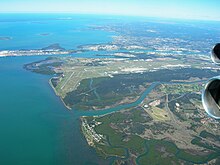

The suburb is 17.9 kilometres (11 mi) north-west of the Brisbane central business district. The suburb is bounded to the north-east by Moreton Bay, to the south-west by Kedron Brook (27°22′23″S 153°06′23″E / 27.3731°S 153.1065°E / -27.3731; 153.1065 (Kedron Brook)), to the south-west by the Gateway Motorway, and to the north-west by Nundah Creek (27°20′09″S 153°05′01″E / 27.3357°S 153.0836°E / -27.3357; 153.0836 (Nundah Creek)).[5] Directly to the south is Brisbane Airport.[5]
Nudgee Creek rises in Nudgee to the west and meanders through Nudgee Beach where it enters Moreton Bay at 27°20′34″S 153°05′39″E / 27.3429°S 153.0941°E / -27.3429; 153.0941 (Nudgee Creek mouth).[5]
There is a small residential area (27°20′45″S 153°06′09″E / 27.3459°S 153.1026°E / -27.3459; 153.1026 (Nudgee Beach residential area)) in the east of the suburb near the beach (27°20′36″S 153°06′03″E / 27.3433°S 153.1009°E / -27.3433; 153.1009 (Nudgee Beach (beach))).[5]
There is a Brisbane City Council waste transfer station (known by the council as a resource recovery centre) in the south of the locality (27°21′40″S 153°06′01″E / 27.3612°S 153.1003°E / -27.3612; 153.1003 (Nudgee Beach Resource Recovery Centre)). The remainder of the locality is mangrove wetlands with the northern part of the suburb being part of the Boondall Wetlands.[5]
There is a network of bike tracks which connect through to Toombul shopping centre.[5]
History

The name Nudgee comes from the Yuggera word in the Yugarabul dialect, nardha meaning place of ducks, from nar meaning duck and dha meaning place.[3]

Nudgee Beach Provisional School opened on 1 April 1926. In 1946 it became Nudgee Beach State School. It closed on 25 March 1988.[6] In 1989 the school reopened as Nudgee Beach Field Study Centre. In 1992 it was renamed Nudgee Beach Environmental Education Centre.[7]
Demographics
At the 2011 census, Nudgee Beach had a population of 261 people. In the 2011 census, Nudgee Beach had a population of 261 people; 48.7% female and 51.3% male. The median age of the Nudgee Beach population was 45 years of age, 8 years above the Australian median. Children aged under 15 years made up 13.8% of the population and people aged 65 years and over made up 17.7% of the population. 77.9% of people living in Nudgee Beach were born in Australia, compared to the national average of 69.8%; the next most common countries of birth were England 4.6%, New Zealand 4.2%, Ireland 2.7%, Germany 1.1%, Papua New Guinea 1.1%. 88.8% of people spoke only English at home; the next most popular languages were 1.9% German, 1.9% Vietnamese, 1.5% Thai, 1.2% Pacific Austronesian Languages. The median weekly household income in Nudgee Beach was $1,224, very similar to the national median of $1,234. Nearly all households in Nudgee Beach (97.0%) were separate houses, there were no semi-detached, row or terrace houses, townhouses etc., and no flats, units or apartments, and 3.0% were classified as "other dwellings". The average household size was 2.5 people.[8]
In the 2016 census, Nudgee Beach had a population of 263 people.[9]
In the 2021 census, Nudgee Beach had a population of 308 people.[1]
Education

Nudgee Beach Environmental Education Centre is an Outdoor and Environmental Education Centre at 1588 Nudgee Road (27°20′54″S 153°06′18″E / 27.3482°S 153.1049°E / -27.3482; 153.1049 (Nudgee Beach Environmental Education Centre)).[10][11]
There are no schools in Nudgee Beach. The nearest primary and secondary school is Earnshaw State College in Banyo.[5]
Amenities
There is a boat ramp and floating walkway at Nudgee Beach Road (27°21′46″S 153°06′10″E / 27.3627°S 153.1029°E / -27.3627; 153.1029 (Nudgee Beach boat ramp)) providing access to Kedron Brook.[12]
There are four canoe ramps:[13]
- from Fortitude Street into Moreton Bay (27°20′37″S 153°06′04″E / 27.3435°S 153.1010°E / -27.3435; 153.1010 (Fortitude Street canoe ramp))
- from O'Quinn Street into Nudgee Creek (27°20′42″S 153°05′52″E / 27.3450°S 153.0978°E / -27.3450; 153.0978 (O'Quinn Street canoe ramp))
- from Mangrove boardwalk into Nudgee Creek (27°20′40″S 153°05′35″E / 27.3444°S 153.0931°E / -27.3444; 153.0931 (Mangrove boardwalk canoe ramp))
- from Boondal Wetlands into Nundah Creek (27°20′41″S 153°05′31″E / 27.3448°S 153.0920°E / -27.3448; 153.0920 (Nundah Creek canoe ramp))
References
- ^ a b c Australian Bureau of Statistics (28 June 2022). "Nudgee Beach (SAL)". 2021 Census QuickStats. Retrieved 28 February 2023.

- ^ "Northgate Ward". Brisbane City Council. Archived from the original on 12 March 2017. Retrieved 12 March 2017.
- ^ a b "Nudgee Beach – suburb in City of Brisbane (entry 43501)". Queensland Place Names. Queensland Government. Retrieved 26 January 2020.
- ^ "Nudgee Beach – beach in City of Brisbane (entry 24803)". Queensland Place Names. Queensland Government. Retrieved 16 April 2020.
- ^ a b c d e f g "Queensland Globe". State of Queensland. Retrieved 15 April 2020.
- ^ Queensland Family History Society (2010), Queensland schools past and present (Version 1.01 ed.), Queensland Family History Society, ISBN 978-1-921171-26-0
- ^ "Our history". Nudgee Beach Environmental Education Centre. 26 September 2019. Archived from the original on 8 March 2020. Retrieved 16 April 2020.
- ^ Australian Bureau of Statistics (31 October 2012). "Nudgee Beach (State Suburb)". 2011 Census QuickStats. Retrieved 15 September 2012.
- ^ Australian Bureau of Statistics (27 June 2017). "Nudgee Beach (SSC)". 2016 Census QuickStats. Retrieved 20 October 2018.
- ^ "State and non-state school details". Queensland Government. 9 July 2018. Archived from the original on 21 November 2018. Retrieved 21 November 2018.
- ^ "Nudgee Beach Environmental Education Centre". Archived from the original on 21 March 2018. Retrieved 21 November 2018.
- ^ "Boating facility locations in Queensland". Marine Safety Queensland. Queensland Government. 17 January 2020. Archived from the original on 19 March 2020. Retrieved 17 April 2020.
- ^ "Boat Ramp locations". Brisbane City Council. Archived from the original on 22 May 2022. Retrieved 17 April 2020.
External links
Wikimedia Commons has media related to Nudgee Beach, Queensland.
- "Nudgee". Queensland Places. Centre for the Government of Queensland, University of Queensland.
- "Nudgee". BRISbites. Brisbane City Council. Archived from the original on 24 July 2008.
- "Nudgee". Our Brisbane. Brisbane City Council. Archived from the original on 6 September 2007.
- v
- t
- e
Suburbs of the City of Brisbane, Queensland
Brisbane River
- Albion
- Alderley
- Anstead
- Ascot
- Ashgrove
- Aspley
- Auchenflower
- Bald Hills
- Banks Creek
- Banyo
- Bardon
- Bellbowrie
- Boondall
- Bowen Hills
- Bracken Ridge
- Bridgeman Downs
- Brighton
- Brisbane Airport
- Brisbane CBD
- Brookfield
- Carseldine
- Chapel Hill
- Chermside
- Chermside West
- Clayfield
- Deagon
- Eagle Farm
- Enoggera
- Enoggera Reservoir
- England Creek
- Everton Park
- Ferny Grove
- Fig Tree Pocket
- Fitzgibbon
- Fortitude Valley
- Gaythorne
- Geebung
- Gordon Park
- Grange
- Hamilton
- Hendra
- Herston
- Indooroopilly
- Kalinga
- Karana Downs
- Kedron
- Kelvin Grove
- Kenmore
- Kenmore Hills
- Keperra
- Kholo
- Lake Manchester
- Lutwyche
- McDowall
- Milton
- Mitchelton
- Moggill
- Mount Coot-tha
- Mount Crosby
- New Farm
- Newmarket
- Newstead
- Northgate
- Nudgee
- Nudgee Beach
- Nundah
- Paddington
- Petrie Terrace
- Pinjarra Hills
- Pinkenba
- Pullenvale
- Red Hill
- Sandgate
- Shorncliffe
- Spring Hill
- St Lucia
- Stafford
- Stafford Heights
- Taigum
- Taringa
- Teneriffe
- The Gap
- Toowong
- Upper Brookfield
- Upper Kedron
- Virginia
- Wavell Heights
- Wilston
- Windsor
- Wooloowin
- Zillmere
Brisbane River
- Acacia Ridge
- Algester
- Annerley
- Archerfield
- Balmoral
- Belmont
- Bulimba
- Burbank
- Calamvale
- Camp Hill
- Cannon Hill
- Capalaba West (defunct)
- Carina
- Carina Heights
- Carindale
- Chandler
- Chelmer
- Chuwar
- Coopers Plains
- Corinda
- Coorparoo
- Darra
- Doolandella
- Drewvale
- Durack
- Dutton Park
- East Brisbane
- Eight Mile Plains
- Ellen Grove
- Fairfield
- Forest Lake
- Graceville
- Greenslopes
- Gumdale
- Hawthorne
- Heathwood
- Hemmant
- Highgate Hill
- Holland Park
- Holland Park West
- Inala
- Jamboree Heights
- Jindalee
- Kangaroo Point
- Karawatha
- Kuraby
- Larapinta
- Lota
- Lytton
- MacGregor
- Mackenzie
- Manly
- Manly West
- Mansfield
- Middle Park
- Morningside
- Mount Ommaney
- Moorooka
- Mount Gravatt
- Mount Gravatt East
- Murarrie
- Nathan
- Norman Park
- Oxley
- Pallara
- Parkinson
- Port of Brisbane
- Ransome
- Richlands
- Riverhills
- Robertson
- Rochedale
- Rocklea
- Runcorn
- Salisbury
- Seven Hills
- Seventeen Mile Rocks
- Sherwood
- Sinnamon Park
- South Brisbane
- Stretton
- Stones Corner
- Sumner
- Sunnybank
- Sunnybank Hills
- Tarragindi
- Tennyson
- Tingalpa
- Upper Mount Gravatt
- Wacol
- Wakerley
- West End
- Westlake
- Willawong
- Wishart
- Woolloongabba
- Wynnum
- Wynnum West
- Yeerongpilly
- Yeronga


