O'Bannon Woods State Park
State park in Harrison County, Indiana, US
38°13′41″N 86°17′46″W / 38.2281°N 86.2961°W / 38.2281; -86.2961O'Bannon Woods State Park is a 2,000-acre (8 km2) state park in the state of Indiana, 32 miles (51 km) west of Louisville, Kentucky.
O'Bannon Woods was originally known as the Wyandotte Woods State Recreation Area, which was part of the Harrison-Crawford State Forest. Its main attraction is Wyandotte Caves, which contain over nine miles of caverns and one of the world's largest underground "mountains". The Blue River runs through the park. Indiana DNR lists it as one of their "Seven Hidden Jewels".
The park was named for former governor Frank O'Bannon and houses the O'Bannon Woods Interpretive Center, which offers exhibits and nature programs year-round. The park receives about 120,000 visitors annually.[1]
-
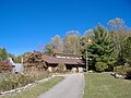 Nature Center
 -
 Duck pond by the Forest office, near the state park entrance.


References
- ^ a b "2018 / 2019 Estimated Fiscal Year Visits for Indiana State Parks ~ Alphabetical" (PDF). Indiana Department of Natural Resources. Retrieved November 2, 2021.
- "O'Bannon Woods State Park". Indiana Department of Natural Resources. Retrieved April 3, 2007.
- United States Geological Survey. "Wyandotte Cave, USGS Leavenworth (IN, KY) Topo Map". TopoQuest. Retrieved July 5, 2008.
Wikimedia Commons has media related to O'Bannon Woods State Park.
- v
- t
- e
Protected areas of Indiana
- Hoosier
- Big Walnut Creek
- Cabin Creek Raised Bog
- Calvert and Porter Woods Nature Preserve
- Cowles Bog
- Donaldson Cave System and Woods
- Dunes Nature Preserve
- Fern Cliff Nature Preserve
- Hanging Rock and Wabash Reef
- Harrison Spring
- Hoosier Prairie
- Marengo Cave
- Meltzer Woods
- Ohio Coral Reef (Falls of the Ohio)
- Pine Hills Natural Area
- Pinhook Bog
- Pioneer Mothers Memorial Forest
- Portland Arch Nature Preserve
- Rise at Orangeville
- Rocky Hollow-Falls Canyon Nature Preserve
- Tamarack Bog Nature Preserve
- Wesley Chapel Gulf
- Wesselman Park Woods
- Wyandotte Cave
- Brown County
- Chain O'Lakes
- Charlestown
- Clifty Falls
- Deam Lake
- Falls of the Ohio
- Fort Harrison
- Harmonie
- Indiana Dunes
- Lincoln
- McCormick's Creek
- Mounds
- O'Bannon Woods
- Ouabache
- Pokagon
- Potato Creek
- Prophetstown
- Shades
- Shakamak
- Spring Mill
- Starve Hollow
- Summit Lake
- Tippecanoe River
- Turkey Run
- Versailles
- White River
- Whitewater Memorial
 Category
- Indianapolis
- Indiana Department of Natural Resources
 Commons

 | This Harrison County, Indiana location article is a stub. You can help Wikipedia by expanding it. |
- v
- t
- e
This article related to a protected area in Indiana is a stub. You can help Wikipedia by expanding it. |
- v
- t
- e
 | This Louisville metro area-related article is a stub. You can help Wikipedia by expanding it. |
- v
- t
- e


