Ogi, Niigata
Former municipality in Hokuriku, Japan
Ogi  Flag  Seal | |
|---|---|
| Country | Japan |
| Region | Hokuriku |
| Prefecture | Niigata Prefecture |
| District | Sado District |
| Merged | March 1, 2004 (now part of Sado) |
| Area | |
| • Total | 25.95 km2 (10.02 sq mi) |
| Population (2000) | |
| • Total | 4,062 |
| Time zone | UTC+09:00 (JST) |

Ogi (小木町, Ogi-machi) was a town located in Sado Island, Niigata Prefecture, Japan.
On March 1, 2004, Ogi and the other 9 municipalities in the island were merged to create the city of Sado.[1] Since then, Ogi has been one of the 10 subdivisions of Sado City.
Transportation
Bus
- Niigata Kotsu Sado
Highway
 National Route 350

Sea
- Ogi Port
- Sado Kisen Terminal
- Car ferry services to/from Naoetsu Port (Jōetsu City)
- Sado Kisen Terminal
-
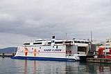 Car ferry Akane

Local attractions
- Shukunegi (ja:宿根木)
- Tarai Bune
- Rengebuji temple
- Ogi Coast
- Yajima, Kyojima
- Kotoura Cave (Ryuodo Cave)
-
 Shukunegi
 -
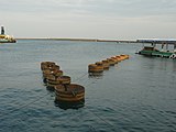 Tarai Bune in Ogi Port
 -
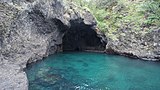 Kotoura Cave (Ryuodo Cave)


See also
References
- ^ 平成の大合併地図帳&都道府県データマップ (in Japanese). 集英社. 2006. p. 17.
External links
- Sado Tourism Association (in English)
- Shukunegi Official Website (in English)
- Sado Steam Ship (in English)
- Sado Geopark (in English)
- v
- t
- e
Dissolved municipalities of  Niigata Prefecture
 Niigata Prefecture
| 2001 | |
|---|---|
| 2005 |
| 2008 |
|---|
| 2005 |
|---|
| 2003 | |
|---|---|
| 2005 |
| 2004 |
|---|
| 2005 |
|---|
| 2005 |
|---|
| 2006 |
|---|
| 2005 |
|---|
| 2005 | |
|---|---|
| 2006 | |
| 2010 |
| 2005 |
|---|
| 2005 |
|---|
| 2004 |
|---|
| 2004 | |
|---|---|
| 2005 |
| 2005 |
|---|
| 2005 |
|
|---|
| 2005 |
|---|
| 2004 |
|---|
Authority control databases | |
|---|---|
| International |
|
| National |
|
 | This Niigata Prefecture location article is a stub. You can help Wikipedia by expanding it. |
- v
- t
- e


