Pampas, Peru
12°23′56″S 74°52′0″W / 12.39889°S 74.86667°W / -12.39889; -74.86667
You can help expand this article with text translated from the corresponding article in Spanish. (February 2009) Click [show] for important translation instructions.
- View a machine-translated version of the Spanish article.
- Machine translation, like DeepL or Google Translate, is a useful starting point for translations, but translators must revise errors as necessary and confirm that the translation is accurate, rather than simply copy-pasting machine-translated text into the English Wikipedia.
- Do not translate text that appears unreliable or low-quality. If possible, verify the text with references provided in the foreign-language article.
- You must provide copyright attribution in the edit summary accompanying your translation by providing an interlanguage link to the source of your translation. A model attribution edit summary is
Content in this edit is translated from the existing Spanish Wikipedia article at [[:es:Pampas]]; see its history for attribution. - You may also add the template
{{Translated|es|Pampas}}to the talk page. - For more guidance, see Wikipedia:Translation.
Place in Huancavelica, Peru

Flag
Coat of arms
Ciudad de los Cuchimichis (The Cuchimichis City)


Pampas
Pampas is a city in Peru. It is the capital of the Tayacaja Province and it was established on June 21, 1825. According to the 2007 census had a population of 9,973 (11,566 in the metropolitan area).[1] It has an approximate altitude of 3,276 metres.
Transportation
The city is connected to the nearby cities like Huancayo and Ayacucho by partially paved roads.[citation needed]
Education
The city house a branch of the Universidad Nacional de Huancavelica and it is home of a local technical institute; the Instituto Tecnologico Pampas - Tayacaja.[citation needed]
Health
The city has now a new hospital, the Hospital Pampas that serve the city and the towns nearby.[citation needed]
Images
-
 A house in Pampas.
 -
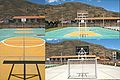 Futsal court in Pampas.
 -
 Slide in the "Parque Ecolgico de Pampas".
 -
 Gardens in the "Parque Ecolgico de Pampas".
 -
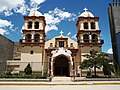 Cathedral of San Pedro de Pampas.
 -
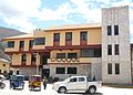 Municipality of Pampas.
 -
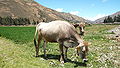 A cow in Pampas.
 -
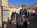 Pampino.


References
- ^ Instituto Nacional de Estadstica e Informtica (2007). "Censos Nacionales 2007: XI de Poblacin y VI de Vivienda" (in Spanish). Archived from the original on May 5, 2012. Retrieved November 12, 2008.
Statistics taken of the agglomeration from Acraquia (799), Ahuaycha (794), Daniel Hernndez (3.946) and Pampas (6.027)
External links
Wikimedia Commons has media related to Pampas (ciudad).
Authority control databases | |
|---|---|
| International |
|
| National |
|


