Paraisópolis, São Paulo
Favela in São Paulo
You can help expand this article with text translated from the corresponding article in Portuguese. (February 2011) Click [show] for important translation instructions.
- View a machine-translated version of the Portuguese article.
- Machine translation, like DeepL or Google Translate, is a useful starting point for translations, but translators must revise errors as necessary and confirm that the translation is accurate, rather than simply copy-pasting machine-translated text into the English Wikipedia.
- Do not translate text that appears unreliable or low-quality. If possible, verify the text with references provided in the foreign-language article.
- You must provide copyright attribution in the edit summary accompanying your translation by providing an interlanguage link to the source of your translation. A model attribution edit summary is
Content in this edit is translated from the existing Portuguese Wikipedia article at [[:pt:Paraisópolis (bairro de São Paulo)]]; see its history for attribution. - You may also add the template
{{Translated|pt|Paraisópolis (bairro de São Paulo)}}to the talk page. - For more guidance, see Wikipedia:Translation.
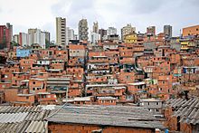
Paraisópolis ("Paradise city", from paraiso paradise (Hisp.) and -polis city (Greek) is a neighborhood of São Paulo city, which is part of the Vila Andrade district, in the south zone.[citation needed] It is located adjacent to the affluent district of Morumbi.[1] Paraisópolis is a favela and is the largest squatted informal settlement in the city.[2] Paraisópolis has an estimated population between 80,000 and 100,000 people. It contains about 20,000 households.[citation needed]
Paraisópolis is known for a 2004 picture by photographer Tuca Vieira. It is considered on the most well-known pictures of Brazil and was taken for the Folha de S.Paulo newspaper. It highlights social inequality, both in Brazil and Latin America in general.[3]
References
- ^ "O lado Morumbi de Paraisópolis". VEJA SÃO PAULO (in Brazilian Portuguese). Retrieved 2018-07-01.
- ^ Scruggs, Gregory (18 July 2019). "Ministry of cities RIP: the sad story of Brazil's great urban experiment". The Guardian. Retrieved 12 April 2021.
- ^ "Inequality ... in a photograph". The Guardian. 2017-11-29. ISSN 0261-3077. Retrieved 2023-12-19.
23°37′00″S 46°43′36″W / 23.61667°S 46.72667°W / -23.61667; -46.72667
- v
- t
- e


