Picacho Peak State Park
32°37′52″N 111°24′56″W / 32.63111°N 111.41556°W / 32.63111; -111.41556
United States historic place
Picacho Pass Skirmish Site--Overland Mail Co. Stage Station at Picacho Pass | |
 Battle of Picacho Pass Monument | |
  | |
| Nearest city | Picacho, Arizona |
|---|---|
| Area | 774 acres (313 ha) |
| Built | 1858 |
| NRHP reference No. | 02001384[2] |
| Added to NRHP | November 22, 2002 |
Picacho Peak State Park is a state park surrounding Picacho Peak in Picacho, Arizona. The park is located between Casa Grande and Tucson near Interstate 10 in Pinal County. Its centerpiece spire is visible from downtown Tucson, a distance of 45 miles (72 km). The summit rises to 3,374 feet (1,028 m) above mean sea level. Though appearing to be the remnant of a volcanic neck, it is now believed to be a tilted and eroded piece of rock overlain by a lava flow.
Name
The place name Picacho Peak is etymologically redundant: picacho means 'peak' in Spanish. In 1775 the peak was referred to as Cerro de Taca 'Taca Hill' by Father Francisco Garcés, using the Oʼodham name Tcacca or Taceo. It was also called Picacho del Tucson 'Tucson Peak' in the past.[3][4]
Description
The park is celebrated for wildflowers that appear mid-February to early April following good winter rain. Though set next to an interstate highway, the park's west face possesses an unspoiled Sonoran Desert setting. A small flat space on top of the spire can be reached via two trail heads. Portions of the trails are precarious, and hikers are aided by cables and catwalks. These additions make the routes some of the few via ferrata in the United States. From the top, there is a view south to the Santa Catalina Mountains near Tucson, east across Interstate 10 to Newman Peak, northwest to Tabletop Mountain near Casa Grande, north to the many mountain ranges surrounding Phoenix, and west to where the north-running Santa Cruz River runs underground supporting farms in a quaint desert valley.
Park rangers recommend that hikers wear sturdy boots and carry two liters of water per person. Gloves are commonly used to help grip the cables.[5]
History
The Butterfield Overland Mail route had a stop near Picacho Peak. The park is near the site of the Battle of Picacho Pass, one of several American Civil War era engagements to occur in Arizona Territory. A Union cavalry patrol from California skirmished with Confederate scouts from Texas, and three men were killed. This marks the second westernmost battle of the American Civil War.[6] Every year during early March, there are reenactments of the battle and other demonstrations of Civil War military history.
Appearances in fiction
Picacho Peak features prominently in the novel The Host by Stephenie Meyer, serving as a guide to the main character in the first act of the story. Much of the action of the novel takes place in or near the state park.
Plane crash
On June 8, 2024, a plane crashed near the summit of Picacho Peak, killing its pilot, 68-year-old James Galvin of Oro Valley.[7]
Gallery
-
 Spring wildflowers at Picacho Peak.
 -
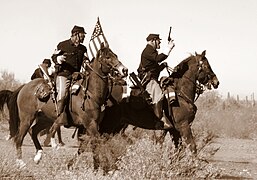 Re-enactment of the Battle of Picacho Peak in March 2007.
 -

-
 Aerial view of Picacho Peak taken from a Boeing B-17 Flying Fortress on April 20, 2013.
 -
 Picacho Peak from the ghost town of Sasco.


See also
 Arizona portal

References
- ^ "Monthly State Parks Visitation Report" (PDF). Arizona Office of Tourism. December 2022.
- ^ "National Register Information System". National Register of Historic Places. National Park Service. July 9, 2010.
- ^ "Picacho Peak". U.S. Geological Survey. Retrieved February 18, 2020.
- ^ The National Gazetteer of the United States of America: Arizona 1986. Denver, CO: Geological Survey. 1987. pp. 472–473.
- ^ Arizona State Parks. "Picacho Peak State Park: Facilities". Retrieved July 12, 2024.
- ^ The westernmost engagement was at Stanwix Station on the Gila River.
- ^ Celaya, Abigail (June 8, 2024). "68-year-old man dead after plane crash at Picacho Peak". Arizona Republic. Retrieved June 8, 2024.
External links
Wikimedia Commons has media related to Picacho Peak State Park.
Wikivoyage has a travel guide for Picacho Peak State Park.
- Picacho Peak State Park
- v
- t
- e
(Yavapai County)
- Boundary Cone
- Fortification Hill
- Mount Wilson
- Mount Union
- Castle Dome
- Carr Peak
- Miller Peak
- Aubrey Peak
- Hualapai Peak
- Lime Peak
- Mae West Peaks
- Four Peaks
- Mount Ord
- East End
- McDowell Peak
- Mount McDowell
- Thompson Peak
- Mount Ballard (Arizona)
- Camelback Mountain
- Mummy Mountain
- Piestewa Peak
- South Mountains
- Sunnyslope Mountain
- Ibex Peak
- Agassiz Peak
- Doyle Peak
- Fremont Peak
- Mount Bigelow
- Mount Lemmon
- Pusch Ridge
- Thimble Peak
- Mount Hopkins
- Mount Wrightson
- Mount Turnbull
- Mistake Peak
- Granite Mountain
- Black Dome
- Sentinel Peak
- Tumamoc Hill
- Apache Peak
- Black Mesa (Navajo County)
- Escudilla Mountain
- Mount Baldy
- Agathla Peak
- Agua Caliente Mountains
- Agua Dulce Mountains
- Antelope Hill
- Aquarius Mountains
- Artillery Mountains
- Atascosa Mountains
- Aubrey Hills
- Baboquivari Peak
- Balakai Mesa
- Beaver Dam Mountains
- Belmont Mountains
- Bill Williams Mountain
- Bitsihuitsos Butte
- Black Hills (Greenlee County)
- Black Mesa (Apache-Navajo Counties)
- Black Mesa (Warm Springs)
- Black Mountain (Maricopa County)
- Black Mountain (Pima County)
- Blackjack Mountains
- Bryan Mountains
- Buckskin Mountain (Arizona-Utah)
- Buckskin Mountains (La Paz County)
- Bush Head
- Cabeza Prieta Mountains
- Canelo Hills
- Carrizo Mountains
- Cerro Colorado Mountains
- Chocolate Mountains
- Copper Mountains
- Coyote Mountains
- Date Creek Mountains
- Dome Rock Mountains
- Dos Cabezas Mountains
- Etoi Ki
- Excalibur
- Galiuro Mountains
- Gavilan Peak
- Gila Bend Mountains
- Gila Mountains (Graham County)
- Gila Mountains (Yuma County)
- Goldfield Mountains
- Grand Wash Cliffs
- Granite Mountains
- Granite Wash Mountains
- Growler Mountains
- Gu Achi Peak
- Guadalupe Mountains
- Harcuvar Mountains
- Harquahala Mountains
- House Mountain
- Hunts Mesa
- Isis Temple
- John the Baptist Mountains
- Juniper Mesa
- Kaibab Plateau
- Kofa Mountains
- Laguna Mountains
- Las Guijas Mountains
- Lime Mountain (Maricopa County}
- Little Harquahala Mountains
- Little Rincon Mountains
- Lukachukai Mountains
- Madrean Sky Islands
- Mescal Mountains
- Mineral Mountains
- Moccasin Mountains
- Mohave Mountains
- Mohawk Mountains
- Mount Trumbull
- Muggins Mountains
- Mustang Mountains
- Navajo Mountain
- The Needles
- New River Mountains
- New Water Mountains
- Newton Butte
- Painted Rock Mountains
- Pajarito Mountains
- Patagonia Mountains
- Peacock Mountains
- Picacho Peak
- Picketpost Mountain
- Pinnacle Peak
- Poachie Range
- Poston Butte
- Rawhide Mountains
- Sacaton Mountains
- San Luis Mountains
- Santa Maria Mountains
- Sevenmile Mountains
- Sierra San Antonio
- Sierra Estrella
- Sierra Madre Occidental
- Sierra Pinta
- Silver Bell Mountains
- Squaw Tits
- Sugarloaf Mountain
- Sunset Mountains
- Swisshelm Mountains
- Tempe Butte
- Temple Butte
- Tinajas Altas Mountains
- Tordillo Mountain
- Tortolita Mountains
- Trigo Mountains
- Tule Mountains
- Tumacacori Mountains
- Virgin Mountains
- Vulcan's Throne
- Vulture Mountains
- Waterman Mountains
- Weaver Mountains
- West Silver Bell Mountains
- White Tank Mountains
- Wickenburg Mountains


