Podvelka
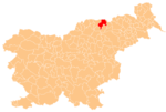
Place in Styria, Slovenia
Coat of arms
 Slovenia
[1]
(2019)[1]
Podvelka (pronounced [pɔˈdʋeːlka]; formerly Ribnica,[2] German: Reifnig[2]) is a village in northeastern Slovenia. It is the seat of the Municipality of Podvelka. It lies in the traditional region of Styria, but belongs to the Carinthia Statistical Region. The settlement is situated on the right bank of the Drava River on the railway line from Maribor to Dravograd.[3]
Name
The name Podvelka was created in the 20th century to designate the train station previously known as Ribnica(-Brezno) (German: Reifnig). The name is a fused prepositional phrase: pod 'below' + Velka. The latter element refers to Velka Creek, which flows from the Pohorje Mountains and empties into the Drava River west of the settlement.[4] The name of the stream is derived from the ellipsis velika (voda) 'large creek'.[5]
References
- ^ a b "Naselje Podvelka". Statistični urad Republike Slovenije. Retrieved March 7, 2020.
- ^ a b Leksikon občin kraljestev in dežel zastopanih v državnem zboru, vol. 4: Štajersko. Vienna: C. Kr. Dvorna in Državna Tiskarna. 1904. p. 262.
- ^ Podvelka municipal site
- ^ "Dravska dolina". Straža. No. 31. April 18, 1919. p. 3. Retrieved July 1, 2024.
- ^ Snoj, Marko (2009). Etimološki slovar slovenskih zemljepisnih imen. Ljubljana: Modrijan. p. 451.
External links
 Media related to Podvelka at Wikimedia Commons
- Podvelka on Geopedia
- v
- t
- e
Municipality of Podvelka
Administrative seat: Podvelka
Authority control databases | |
|---|---|
| International |
|
| National |
|
 | This article about the Municipality of Podvelka in Slovenia is a stub. You can help Wikipedia by expanding it. |
- v
- t
- e


