Ramshorn Peak
Mountain in Wyoming, United States


Ramshorn Peak
Location in Wyoming
Show map of Wyoming
Ramshorn Peak
Ramshorn Peak (the United States)
Show map of the United StatesRocky Mountains
Ramshorn Peak is an 11,635-foot-elevation (3,546-meter) mountain summit located in Fremont County of Wyoming, United States.[3]
Description
The peak is situated approximately 16 miles east of the Continental Divide in the Absaroka Range. It is set in the Washakie Wilderness, on land managed by Shoshone National Forest. Topographic relief is significant as both the east and west aspects rise 2,000 feet (610 meters) in one-half mile. The nearest town is Dubois, Wyoming, 16 miles to the south-southeast, and the peak is a conspicuous landmark seen from U.S. Route 26 / U.S. 287. The mountain's name has been officially adopted by the United States Board on Geographic Names, and was in use in 1914 when published in an USGS bulletin.[3][4] The first ascent of the summit was made July 13, 1960, by H. & Mrs. Kellogg.[5]
Climate
According to the Köppen climate classification system, Ramshorn Peak is located in an alpine subarctic climate zone with cold, snowy winters, and cool to warm summers.[6] Due to its altitude, it receives precipitation all year, as snow in winter, and as thunderstorms in summer. Precipitation runoff from the mountain drains into tributaries of the Wind River.
See also
Gallery
-
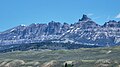 Ramshorn Peak from SSW at Union Pass, zoomed in
 -
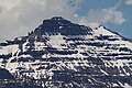 Southeast aspect
 -
 Dubois with Ramshorn Peak to the north


References
- ^ a b "Ramshorn Peak, Wyoming". Peakbagger.com. Retrieved 2021-08-01.
- ^ a b c "Ramshorn Peak - 11,635' WY". listsofjohn.com. Retrieved 2021-08-01.
- ^ a b c "Ramshorn Peak". Geographic Names Information System. United States Geological Survey, United States Department of the Interior. Retrieved 2021-08-01.
- ^ USGS, 1914, US Government Printing Office, page 139.
- ^ Orrin H. Bonney, Lorraine G. Bonney, 1965, Guide to the Wyoming Mountains and Wilderness Areas, Sage Books, page 418.
- ^ Peel, M. C.; Finlayson, B. L.; McMahon, T. A. (2007). "Updated world map of the Köppen−Geiger climate classification". Hydrol. Earth Syst. Sci. 11. ISSN 1027-5606.
External links
- Weather forecast: Ramshorn Peak
- Climbing Ramshorn Peak: Selectpeaks.com
- v
- t
- e
- Abiathar Peak
- Atkins Peak
- Barronette Peak
- Breccia Peak
- Clayton Mountain
- Colter Peak
- Druid Peak
- Eagle Peak
- Fortress Mountain
- Francs Peak
- Index Peak
- Mount Chittenden
- First Peoples Mountain
- Mount Hornaday
- Mount Langford
- Mount Norris
- Mount Schurz
- Mount Stevenson
- Pilot Peak
- Sheep Mesa
- The Thunderer
- Washakie Needles
- Younts Peak
| Bear Lodge Mountains | |
|---|---|
| Others |
- Antler Peak
- Bannock Peak
- Bunsen Peak
- Clagett Butte
- Dome Mountain (Park County)
- Echo Peak
- Gray Peak
- Joseph Peak
- Mount Everts
- Mount Haynes
- Mount Holmes
- Mount Jackson
- Purple Mountain
- Quadrant Mountain
- Sepulcher Mountain
- Terrace Mountain
- Three Rivers Peak
- Trilobite Point
- White Peaks
- Darwin Peak
- Doubletop Peak
- Sheep Mountain
- Elk Mountain (Carbon County)
- Medicine Bow Peak
- Albright Peak
- Battleship Mountain
- Bivouac Peak
- Buck Mountain
- Cathedral Group
- Cleaver Peak
- Cloudveil Dome
- Disappointment Peak
- Doane Peak
- Dry Ridge Mountain
- Eagles Rest Peak
- Elk Mountain (Teton County)
- Forellen Peak
- Fossil Mountain
- Grand Teton
- Green Lakes Mountain
- Housetop Mountain
- The Jaw
- Littles Peak
- Maidenform Peak
- Middle Teton
- Moose Mountain
- Mount Bannon
- Mount Glory
- Mount Hunt
- Mount Jedediah Smith
- Mount Meek
- Mount Moran
- Mount Owen
- Mount Saint John
- Mount Wister
- Mount Woodring
- Mount Woodrow Wilson
- Nez Perce Peak
- Owl Peak
- Prospectors Mountain
- Rammell Mountain
- Ranger Peak
- Raynolds Peak
- Red Mountain
- Rendezvous Mountain
- Rendezvous Peak
- Rock of Ages
- Rockchuck Peak
- Rolling Thunder Mountain
- Shadow Peak
- South Teton
- Spearhead Peak
- Static Peak
- Survey Peak
- Symmetry Spire
- Table Mountain
- Teepe Pillar
- Teewinot Mountain
- Temple Peak
- Thor Peak
- Traverse Peak
- Veiled Peak
- The Wall
- Window Peak
- American Legion Peak
- Atlantic Peak
- Bair Peak
- Bastion Peak
- Bastion Peak-Northeast Peak
- Bears Ears Mountain
- Big Sandy Mountain
- Block Tower
- Bow Mountain
- Brown Cliffs North
- Cathedral Peak
- Desolation Peak
- Dog Tooth Peak
- Dome Mountain (Hot Springs County)
- Doublet Peak
- Downs Mountain
- East Temple Peak
- Flagstone Peak (Fremont County)
- Fremont Peak
- Gannett Peak
- Harrower Peak
- Henderson Peak
- Jackson Peak
- Klondike Peak
- Knife Point Mountain
- Lander Peak
- Lizard Head Peak
- Mitchell Peak
- Mount Bonneville
- Mount Chauvenet
- Mount Febbas
- Mount Helen
- Mount Hooker
- Mount Koven
- Mount Lander
- Mount Nystrom
- Mount Owen
- Mount Sacagawea
- Mount Warren
- Mount Washakie
- Mount Whitecap
- Overhanging Tower
- Payson Peak
- Pingora Peak
- Pylon Peak
- Raid Peak
- Rampart Peak
- Roaring Fork Mountain
- Roberts Mountain
- Shale Mountain
- Sharks Nose
- South Downs Mountain
- The Sphinx
- Split Mountain
- Sunbeam Peak
- Three Waters Mountain
- Torrey Peak
- Turret Peak
- Twin Peaks
- Union Peak
- Valentine Mountain
- Valentine Peak
- War Bonnet Peak
- Warrior Peaks
- Watch Tower
- Whiskey Mountain
- Wind River Peak
- Wolfs Head
- Amethyst Mountain
- Aspen Mountain
- Barlow Peak
- Bridger Mountains
- Cook Peak
- Copper Mountain
- Dirty Mountain
- Douglas Knob
- Dunraven Peak
- Factory Hill
- Ferris Mountains
- Folsom Peak
- Garfield Peak
- Granite Mountains
- Granite Peak
- Heart Mountain
- Hedges Peak
- Hoyt Peak
- Jelm Mountain
- Mansface Hill
- Mount Hancock
- Mount Leidy
- Mount Sheridan
- Mount Washburn
- National Park Mountain
- Owl Creek Mountains
- Prospect Peak (Park County)
- Rawhide Buttes
- Roaring Mountain
- Sierra Madre Range
- Signal Mountain
- Snake River Range
- Specimen Ridge
- Sublette Mountain
- Tongue Butte
- Trischman Knob
- White Mountain
- Wilkins Peak
Portals:
 Geography
 Geology
 Mountains


