Salle, Nepal
Haleshi Tuwachung Municipality Ward No.9 in Sagarmatha Zone, Nepal
Salle, Nepal सल्ले | |
|---|---|
Haleshi Tuwachung Municipality Ward No.9 | |
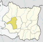
 Location of the Khotang district, Nepal | |
| 27°14′N 86°38′E / 27.23°N 86.63°E / 27.23; 86.63 | |
| Country |  Nepal Nepal |
| Zone | Sagarmatha Zone |
| District | Khotang District |
| Population (1195) | |
| • Total | 1,195 |
| Time zone | UTC+5:45 (Nepal Time) |
Salle is a village and Haleshi Tuwachung Municipality Ward No.9 (Nepal) in Khotang District in the Sagarmatha Zone of eastern Nepal. At the time of the 1991 Nepal census it had a population of 1,931 persons living in 357 individual households.[1]
References
- ^ "Nepal Census 2001". Nepal's Village Development Committees. Digital Himalaya. Retrieved 30 September 2008.
External links
- UN map of the municipalities of Khotang District
- v
- t
- e
Khotang District
Headquarters: Diktel
- Rupakot Majhuwagadhi
- Halesi Tuwachung
For former VDCs See here
 | This article about a location in Khotang District, Nepal is a stub. You can help Wikipedia by expanding it. |
- v
- t
- e


