Sedalia, West Virginia
Unincorporated community in West Virginia
39°21′35″N 80°34′43″W / 39.35972°N 80.57861°W / 39.35972; -80.57861 United States
 West Virginia
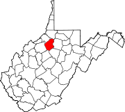
 Doddridge
Sedalia is an unincorporated community in McClellan District, Doddridge County, West Virginia, United States. The community is located along Robinson Fork, a tributary of McElroy Creek.[2] Its former post office[3] is now closed.
The community most likely has the name of an early settler.[4]
References
- ^ U.S. Geological Survey Geographic Names Information System: Sedalia, West Virginia
- ^ The National Map, accessed 2013-12-14
- ^ U.S. Geological Survey Geographic Names Information System: Sedalia WV post office
- ^ Kenny, Hamill (1945). West Virginia Place Names: Their Origin and Meaning, Including the Nomenclature of the Streams and Mountains. Piedmont, WV: The Place Name Press. p. 561.
- v
- t
- e
Municipalities and communities of Doddridge County, West Virginia, United States
County seat: West Union
communities
- West Virginia portal
- United States portal
 | This article about a location in Doddridge County, West Virginia is a stub. You can help Wikipedia by expanding it. |
- v
- t
- e


