St Gluvias
| |
|---|---|
 St Gluvias Church | |
 St Gluvias Location within Cornwall | |
| OS grid reference | SW782345 |
| Civil parish | |
| Unitary authority | |
| Ceremonial county | |
| Region | |
| Country | England |
| Sovereign state | United Kingdom |
| Post town | PENRYN |
| Postcode district | TR10 |
| Dialling code | 01326 |
| Police | Devon and Cornwall |
| Fire | Cornwall |
| Ambulance | South Western |
| UK Parliament | |
St Gluvias is a settlement in Cornwall, England, United Kingdom. The village is now a suburb on the northern edge of Penryn which is two miles (3.2 km) northwest of Falmouth.[1] Until 1 April 2021 there was a civil parish called St Gluvias which doesn't include the suburb but it was renamed to Ponsanooth.[2]
Church history
[edit]The historic parish church of St Gluvias, dedicated to Gluvias of Cornwall (or Gluviacus) serves the Church of England parish of St Gluvias with Penryn.[3] Gluvias of Cornwall was the son of Gwynllyw the warrior, King of Gwentlog, and a nephew of St Petroc. The church was founded in the 6th century and the parish was in the Middle Ages sometimes called Behethlan or Bohelland.[4] In 1881 the church was in a dilapidated state and in need of thorough repair.[5] It was rebuilt by J. P. St Aubyn in 1883 although the medieval tower survived and is built of blocks of granite. The church contains the brass of Thomas Kyllygrewe, c. 1485.[6] There are also three wall-monuments of interest: Samuel Pendarves, d. 1693, and his wife; William Pendarves, d. 1671, and his wife (both are curiously positioned with the figures which should face each other on either side of the corners of a window opening); and J. Kempe, d. 1711, bust under drapery.[7]
The Wesleyan missionary Benjamin Carvosso was born in this parish. Samuel Argall was buried here on 28 January 1626.
There are two Cornish crosses in the parish; one at Enys and one at Penryn. The cross at Enys was originally at Sancreed and was set up at Enys in 1848. The small cross at Penryn was once built into the fish market; when this was pulled down the cross was saved and resited near the town hall in 1895.[8]
-
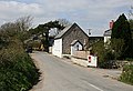 A former Methodist chapel at Laity Moor, now a Greek Orthodox church
 -
 The Cornish cross at Enys

.jpg)
See also
[edit]References
[edit]- ^ Ordnance Survey: Landranger map sheet 204 Truro & Falmouth ISBN 978-0-319-23149-4
- ^ "The Cornwall (Reorganisation of Community Governance) No. 1 Order 2020" (PDF). Local Government Boundary Commission for England. Retrieved 6 July 2021.
- ^ "St Gluvias parish". Retrieved 30 November 2009.
- ^ Doble, G. H. (1964) The Saints of Cornwall: part 3. Truro: Dean and Chapter; pp. 15–19
- ^ "Penryn". The Cornishman. No. 169. 6 October 1881. p. 6.
- ^ Dunkin, E. (1882) Monumental Brasses. London, Spottiswoode
- ^ Pevsner, N. (1970) Cornwall; 2nd ed., revised by Enid Radcliffe. Penguin Books; pp. 177–78
- ^ Langdon, A. G. (1896) Old Cornish Crosses. Truro: Joseph Pollard; pp. 47–48 & 177
- Brown, H. Miles (1945) A Cornish Incumbency, 1741-1776 (John Penrose of St Gluvias). [Wendron?]: H. M. Brown
External links
[edit]![]() Media related to St Gluvias at Wikimedia Commons
Media related to St Gluvias at Wikimedia Commons
- "Online Catalogue for St Gluvias". Cornwall Record Office.
| Unitary authorities | |
|---|---|
| Major settlements (cities in italics) |
|
| Rivers | |
| Topics | |
This article about a location in the former district of Kerrier, Cornwall is a stub. You can help Wikipedia by expanding it. |