Tamarack Peak
Mountain in the American state of Nevada


Tamarack Peak
Location in Nevada
Show map of Nevada
Tamarack Peak
Tamarack Peak (the United States)
Show map of the United StatesCarson Range
Tamarack Peak is a 9,897-foot-elevation mountain summit located in Washoe County, Nevada, United States.
Description
Tamarack Peak is set six miles north of Lake Tahoe on the boundary that Lake Tahoe Basin Management Unit shares with Humboldt-Toiyabe National Forest.[6] It is part of the Carson Range, which is a subset of the Sierra Nevada. It is situated 1.4 miles (2.3 km) east of line parent Relay Peak, 1.8 miles (2.9 km) south of Mount Rose and five miles (8.0 km) north of Incline Village. Topographic relief is modest as the summit rises 1,344 feet (410 meters) above Tahoe Meadows in one mile. Precipitation runoff from this mountain drains north into headwaters of Galena Creek, and south to Ophir Creek. The Tahoe Rim Trail traverses the slopes of the peak, providing an approach option.
Etymology
This landform's toponym was officially adopted in 1988 by the U.S. Board on Geographic Names.[5] The peak is named for the Tamarack tree, a member of the larch family which does not grow in this region,[6] but may have been confused with the Tamarack pine (Pinus contorta murrayana), also called Sierra lodgepole pine, which is a common tree around Lake Tahoe.[7]
Climate
According to the Köppen climate classification system, Tamarack Peak is located in an alpine climate zone.[8] Most weather fronts originate in the Pacific Ocean, and travel east toward the Sierra Nevada mountains. As fronts approach, they are forced upward by the peaks (orographic lift), causing them to drop their moisture in the form of rain or snowfall onto the range. Most of the snow in Nevada falls from December through March.[9]
See also
- List of Lake Tahoe peaks
 Mountains portal

Gallery
-
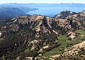
 South aspect
 -
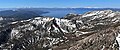
 Tamarack Peak and Lake Tahoe seen from Mt. Rose
 -
 North aspect of Tamarack Peak from Galena Creek Upper Meadow
 -
 North aspect of Tamarack Peak (left of center) seen from Mt. Rose
(Relay Peak in upper right corner) -
 West aspect
 -
 Tamarack Peak (left) and Mt. Rose (right)


References
- ^ United States Board on Geographic Names (1988), Decisions on Geographic Names in the United States, List 8803, Department of the Interior, p. 9
- ^ United States Geological Survey topographical map - Mount Rose
- ^ "Tamarack Peak, Nevada". Peakbagger.com. Retrieved 2022-07-25.
- ^ a b c "Tamarack Peak - 9,897' NV". listsofjohn.com. Retrieved 2022-07-25.
- ^ a b "Tamarack Peak". Geographic Names Information System. United States Geological Survey, United States Department of the Interior. Retrieved 2022-07-25.
- ^ a b Michael C. White (2018), 50 of the Best Snowshoe Trails Around Lake Tahoe, University of Nevada Press, ISBN 9781943859801
- ^ Toree Warfield, June 24, 2015, What’s the dominant pine tree at Lake Tahoe? You might be surprised, Sierrasun.com
- ^ "Climate of the Sierra Nevada". Encyclopædia Britannica.
- ^ John G. Houghton (1975), Nevada's Weather and Climate, Nevada Bureau of Mines and Geology, University of Nevada, p. 53
External links
- Weather forecast: Tamarack Peak
Places adjacent to Tamarack Peak | ||||||||||||||||
|---|---|---|---|---|---|---|---|---|---|---|---|---|---|---|---|---|
| ||||||||||||||||


