Tampico Bridge
Bridge in Veracruz, Mexico
22°13′42″N 97°50′13″W / 22.22833°N 97.83694°W / 22.22833; -97.83694Pueblo Viejo Municipality, Veracruz,
Mexico

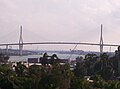
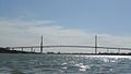
The Tampico Bridge (Spanish: Puente Tampico) is a vehicular cable-stayed bridge connecting the Mexican states of Tamaulipas and Veracruz in eastern Mexico.
Geography
The bridge crosses the Pánuco River near the coast of the Gulf of Mexico.
It connects the city of Tampico in Tamaulipas and Pueblo Viejo Municipality in Veracruz.
Design and engineering
The bridge has been in service since 1988 and was designed by Professor Modesto Armijo from COMEC, a Mexican engineering company. It was designed to withstand the severe Atlantic hurricanes from the Gulf of Mexico.
The bridge uses an orthotropic steel deck girder for a central section of the 360 metres (1,180 ft) long main span, while the rest of the main span and the short lateral spans are a prestressed concrete girder. Both steel and concrete deck girders have the same external shape. This original design principle was later used for the 756-metre (2,480 ft) main span of the Pont de Normandie, a cable-stayed bridge in Normandy, France.
The dynamic analysis of the bridge under turbulent cyclonic winds, as well as the revision of the structural project, and the geometry plus stress control of the bridge during erection, were achieved by Alain Chauvin from Sogelerg, using the French "Scanner" computer program.
Toll
The bridge is tolled by Caminos y Puentes Federales, which charges cars 38 pesos to use it, as of July 2024.[1]
Gallery


References
- ^ a b CAPUFE: Tarifas Vigentes, January 31, 2017
External links
Wikimedia Commons has media related to Tampico Bridge.
- v
- t
- e


