The Steeples
Mountain in British Columbia, Canada


The Steeples
Location of The Steeples in British Columbia
Show map of British Columbia
The Steeples
The Steeples (Canada)
Show map of CanadaCanadian Rockies
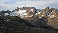
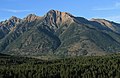
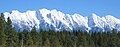
The Steeples is a 2,843-metre (9,327-foot) elevation mountain ridge located at the southern end of the Hughes Range in the Canadian Rockies of British Columbia, Canada. Situated immediately east of Norbury Lake Provincial Park and the Rocky Mountain Trench, this prominent five kilometres in length ridge is visible from the Crowsnest Highway and Cranbrook. The nearest higher peak is Mount Fisher, 10.0 km (6.2 mi) to the north-northwest.[1]
History
The Steeples was named in August 1858 by Thomas Blakiston of the Palliser Expedition as presumably it was believed to resemble church steeples.[3]
The mountain's toponym was officially adopted in 1950 when approved by the Geographical Names Board of Canada.[2][4]
Climate
Based on the Köppen climate classification, The Steeples has a subarctic climate with cold, snowy winters, and mild summers.[5] Winter temperatures can drop below −20 °C with wind chill factors below −30 °C. Precipitation runoff from the mountain drains into tributaries of the Kootenay River.
See also
 Mountains portal
 Canada portal