Trinity Beach, Queensland
Map all coordinates using OpenStreetMap
Download coordinates as:
- KML
- GPX (all coordinates)
- GPX (primary coordinates)
- GPX (secondary coordinates)
Suburb of Cairns, Queensland, Australia
16°47′36″S 145°41′48″E / 16.7933°S 145.6966°E / -16.7933; 145.6966 (Trinity Beach (centre of suburb))- 19.6 km (12 mi) NNW of Cairns CBD
- 365 km (227 mi) NNW of Townsville
- 1,726 km (1,072 mi) NNW of Brisbane
| Suburbs around Trinity Beach: | ||
| Kewarra Beach | Coral Sea | Coral Sea |
| Macalister Range | Trinity Beach | Coral Sea |
| Smithfield | Smithfield | Trinity Park |
Trinity Beach is a coastal suburb of Cairns in the Cairns Region, Queensland, Australia.[2] In the 2021 census, Trinity Beach had a population of 6,594 people.[1]
Geography
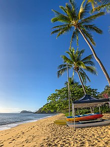
Trinity Beach is approximately 20 kilometres (10 mi) from the Cairns city centre and approximately 6.6 km from Smithfield. Trinity Beach is also a beach stretching for about a mile on the eastern coast of Australia bounded by the Coral Sea.[3] The suburb itself is approximately 2 km wide.
History

Trinity Beach is situated in the Djabugay (Tjapukai) traditional Aboriginal country. [4]
The origin of the suburb name is derived from Trinity Bay.[5]
From 1943 to 1944, Trinity Beach was the site of intensive training in amphibious warfare for Australian and American troops in the context of World War II.[6]
Trinity Beach State School opened on 30 January 1979.[7]
As part of Mulgrave Shire, Trinity Beach experienced suburban development beginning in the 1970s,[8] leading to a population of over 2000 by the mid-1980s.[9]
Trinity Beach became part of the new City of Cairns with the amalgamation of Mulgrave Shire into the new city on 22 March 1995.[10]
In 2000, Cyclone Steve, which made landfall in the Cairns northern beaches area near Trinity Beach,[11] caused significant damage to the roof of the Trinity Beach Hotel.[12]
From 2004 to 2008, the 173-ha Bluewater subdivision,[13] which extends through both Trinity Beach and Trinity Park, was approved for development.[14] As with several other areas in Trinity Beach, portions of the estate sit in a flood zone[15] due to potential inflows from Moore's Gully, which led to a substantial flooding mitigation project for the development in 2010.[16]
In 2023, Trinity Beach was affected by Cyclone Jasper and the resulting 2023 Cairns floods. On 13 December, as the cyclone made landfall, the Trinity Beach waterfront experienced a storm surge event,[17] while soon after overnight, multiple waterfront businesses were vandalised and looted.[18][19]
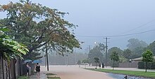
On the morning of 17 December, like other Cairns northern beaches suburbs, Trinity Beach experienced flooding. This flooding led to an evacuation warning for the Bluewater Estate[20][21] and major road closures,[22][23] which resulted in isolation from the rest of Cairns.[24] Videos on social media soon emerged showing inundated residential neighbourhoods in the suburb. The beach itself was thickly covered with debris in the aftermath of the flooding.[25]
Demographics
In the 2011 census, Trinity Beach had a population of 4,734 people.[26]
In the 2016 census, Trinity Beach had a population of 5,488 people.[27]
In the 2021 census, Trinity Beach had a population of 6,594 people.[1]
Education
Trinity Beach State School is a government primary (Prep-6) school for boys and girls at Wewak Street (16°47′41″S 145°41′22″E / 16.7948°S 145.6895°E / -16.7948; 145.6895 (Trinity Beach State School)).[28][29] It includes a special education program.[28] In 2016, the school had an enrolment of 923 students with 60 teaching staff (57 full-time equivalent) and 36 non-teaching staff (22 full-time equivalent).[30] In 2018, the school had an enrolment of 1,027 students with 68 teachers (64 full-time equivalent) and 49 non-teaching staff (32 full-time equivalent).[31]
There are no secondary schools in Trinity Beach. The nearest government secondary school is Smithfield State High School in neighbouring Smithfield to the south.[32]
Amenities
Trinity Beach Community Hall is at 51 Trinity Beach Road (16°47′22″S 145°41′39″E / 16.78940°S 145.69424°E / -16.78940; 145.69424 (Trinity Beach Community Hall)). As at April 2024, a new community hall is under construction by the Cairns Regional Council.[33]
References
- ^ a b c Australian Bureau of Statistics (28 June 2022). "Trinity Beach (SAL)". 2021 Census QuickStats. Retrieved 28 February 2023.

- ^ "Trinity Beach – suburb (entry 48906)". Queensland Place Names. Queensland Government. Retrieved 10 April 2016.
- ^ "Trinity Beach – beach (entry 41949)". Queensland Place Names. Queensland Government. Retrieved 10 April 2016.
- ^ "First people cultural history". Cairns Regional Council. Archived from the original on 9 April 2020. Retrieved 23 June 2020.
- ^ "T Suburbs" (PDF). Cairns Regional Council. Retrieved 23 June 2020.
- ^ "Beaches". Cairns Regional Council. Retrieved 27 December 2023.
- ^ Queensland Family History Society (2010), Queensland schools past and present (Version 1.01 ed.), Queensland Family History Society, ISBN 978-1-921171-26-0
- ^ "Trinity Beach". Centre for the Government of Queensland. Retrieved 27 December 2023.
- ^ "Mulgrave Shire". Retrieved 27 December 2023.
- ^ "Mulgrave Shire Council". Queensland Government. Retrieved 27 December 2023.
- ^ Callaghan, J. 2003. The Tropical Cyclone Risk in Cairns. Natural Hazards 30, 129-153.
- ^ "Australia's worst cyclones". The Daily Telegraph. Retrieved 27 December 2023.
- ^ "Multiplex Development and Opportunity Fund" (PDF). Retrieved 27 December 2023.
- ^ "Queensland Government ArchivesSearch". Queensland Government. Retrieved 27 December 2023.
- ^ "Predictive flood inundation maps". Cairns Regional Council. Retrieved 27 December 2023.
- ^ "Tropical Sustainable Design Case Studies: Moore's Gully" (PDF). James Cook University. Retrieved 27 December 2023.
- ^ "Jasper's Fury: Far North Queensland reels from widespread flooding". The Courier-Mail. Retrieved 27 December 2023.
- ^ "Police increase patrols in cyclone-affected areas after thefts". Nine News. Retrieved 27 December 2023.
- ^ "Break and enters, Trinity Beach and Palm Cove". Retrieved 27 December 2023.
- ^ "Emergency Alert for Bluewater Estate". Retrieved 27 December 2023.
- ^ "Leave Immediately – Blue Water Estate". Retrieved 27 December 2023.
- ^ "Cairns Disaster Dashboard". Cairns Regional Council. Retrieved 17 December 2023.
- ^ "Cairns cut off by floodwaters, towns evacuated and drinking water at risk as former Cyclone Jasper continues to devastate". ABC News. Retrieved 27 December 2023.
- ^ "Stranded residents face isolation in flood-hit Cairns". Special Broadcasting Service. Retrieved 27 December 2023.
- ^ "December rainfall records smashed – as it happened". The Guardian. Retrieved 27 December 2023.
- ^ Australian Bureau of Statistics (31 October 2012). "Trinity Beach (SSC)". 2011 Census QuickStats. Retrieved 5 March 2018.
- ^ Australian Bureau of Statistics (27 June 2017). "Trinity Beach (SSC)". 2016 Census QuickStats. Retrieved 20 October 2018.
- ^ a b "State and non-state school details". Queensland Government. 9 July 2018. Archived from the original on 21 November 2018. Retrieved 21 November 2018.
- ^ "Trinity Beach State School". Trinity Beach State School. 29 November 2020. Retrieved 23 August 2023.
- ^ "Annual Report 2016" (PDF). Trinity Beach State School. Archived (PDF) from the original on 4 March 2018. Retrieved 5 March 2018.
- ^ "ACARA School Profile 2018". Australian Curriculum, Assessment and Reporting Authority. Archived from the original on 27 August 2020. Retrieved 28 January 2020.
- ^ "Queensland Globe". State of Queensland. Retrieved 23 August 2023.
- ^ "Community Halls". Cairns Regional Council. 30 May 2022. Retrieved 24 April 2024.
External links
Wikimedia Commons has media related to Trinity Beach, Queensland.
- "Trinity Beach". Queensland Places. Centre for the Government of Queensland, University of Queensland.
- v
- t
- e
Towns, suburbs and localities in the Cairns Region, Queensland
- Aeroglen
- Aloomba
- Babinda
- Barron
- Barron Gorge
- Bartle Frere
- Bayview Heights
- Bellenden Ker
- Bentley Park
- Bramston Beach
- Brinsmead
- Bungalow
- Cairns
- Cairns City
- Cairns North
- Caravonica
- Clifton Beach
- Deeral
- Earlville
- East Russell
- East Trinity
- Edge Hill
- Edmonton
- Ellis Beach
- Eubenangee
- Fishery Falls
- Fitzroy Island
- Freshwater
- Giangurra
- Glen Boughton
- Goldsborough
- Gordonvale
- Green Hill
- Green Island
- Holloways Beach
- Kamerunga
- Kanimbla
- Kewarra Beach
- Lamb Range
- Little Mulgrave
- Macalister Range
- Machans Beach
- Manoora
- Manunda
- Mirriwinni
- Mooroobool
- Mount Peter
- Mount Sheridan
- Ngatjan
- Packers Camp
- Palm Cove
- Parramatta Park
- Portsmith
- Redlynch
- Smithfield
- Stratford
- Trinity Beach
- Trinity Park
- Waugh Pocket
- Westcourt
- White Rock
- Whitfield
- Woopen Creek
- Wooroonooran
- Woree
- Wrights Creek
- Yorkeys Knob
Main Article: Local government areas of Queensland


