Yendi | |
|---|---|
 The Yendi cathedral | |
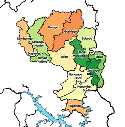
Location of Yendi in Northern region | |
| Coordinates: 9°25′57″N 0°0′15″W / 9.43250°N 0.00417°W | |
| Country | Ghana |
| Region | Northern Region |
| District | Yendi Municipal District |
| Population (2012) | |
• Total | 52,008[1] |
| Time zone | GMT |
| • Summer (DST) | GMT |
Yendi (Dagbani: Yani, meaning "Seat of the Yaa Naa"), is the traditional capital of the Kingdom of Dagbon and the administrative centre of the Yendi Municipal District in the Northern Region of Ghana.[2] As of 2021, the population of Yendi was 154,421 comprising 76,142 males and 78,279 females.[3][1] It is the seat of the King of the Dagbon, Ghana's oldest kingdom.
History
[edit]
King Nyagse constructed Yendi between 1420 and 1500.[4] Yendi is the capital of the Kingdom of Dagbon.[5] The area was abandoned due to an invasion by King Sumaila Ndewura Jakpa of Gonja, which resulted in the death of the Dagbonian King Dariziogo.[4] Yendi was conquered by the Asante Empire under the leadership of Opoku Ware I in 1744 or 1745, but there is academic dispute about the verifiability of this.[6]
The area was taken over by the German Empire and incorporated into Togoland in 1901.[7] The Ya Na resumed their control over Dagbon after the British seized Togoland from Germany as a result of World War I.[8]
23 people were killed in a massacre by the Ghanaian army on 9 September 1969.[9][10] In 2002, a massacre in Yendi killed at least 30 people, including Yakubu II.[11]
Politics
[edit]In the 1969 parliamentary election Shanni Hazrat Mahama, the nominee of the Progress Party, defeated by the National Alliance of Liberals' candidate by a vote of 3,987 to 3,343.[12]
Education
[edit]A trade school was established in Yendi in 1922.[13]
Economy
[edit]The value of trade going through Yendi rose from RM 11,848 in 1905, to RM 27,250 in 1907, and RM 51,152 in 1909.[14]
In 2004, proposals surfaced to link iron ore mines in the vicinity of Yendi by rail.[15]
Climate
[edit]| Climate data for Yendi (1981–2010) | |||||||||||||
|---|---|---|---|---|---|---|---|---|---|---|---|---|---|
| Month | Jan | Feb | Mar | Apr | May | Jun | Jul | Aug | Sep | Oct | Nov | Dec | Year |
| Mean daily maximum °C (°F) | 35.5 (95.9) |
37.7 (99.9) |
38.1 (100.6) |
36.3 (97.3) |
34.2 (93.6) |
31.8 (89.2) |
30.2 (86.4) |
29.9 (85.8) |
30.8 (87.4) |
32.6 (90.7) |
35.3 (95.5) |
35.3 (95.5) |
34.0 (93.1) |
| Mean daily minimum °C (°F) | 20.3 (68.5) |
23.0 (73.4) |
25.0 (77.0) |
25.1 (77.2) |
24.0 (75.2) |
22.7 (72.9) |
22.3 (72.1) |
22.1 (71.8) |
21.9 (71.4) |
22.1 (71.8) |
20.7 (69.3) |
19.8 (67.6) |
22.4 (72.4) |
| Average rainfall mm (inches) | 3.8 (0.15) |
4.7 (0.19) |
43.3 (1.70) |
89.2 (3.51) |
116.6 (4.59) |
170.6 (6.72) |
180.9 (7.12) |
228.8 (9.01) |
262.0 (10.31) |
101.0 (3.98) |
6.5 (0.26) |
2.8 (0.11) |
1,210.2 (47.65) |
| Average rainy days (≥ 0.1 mm) | 1 | 1 | 3 | 5 | 8 | 11 | 11 | 14 | 16 | 9 | 1 | 1 | 81 |
| Source: World Meteorological Organization[16] | |||||||||||||
See also
[edit]References
[edit]- ^ a b "World Gazetteer online". World-gazetteer.com. Archived from the original on September 30, 2007.
- ^ Northern » Yendi Municipal district Archived March 5, 2013, at the Wayback Machine
- ^ "Ghana Districts: A repository of all Local Assemblies in Ghana". www.ghanadistricts.com. Retrieved December 20, 2023.
- ^ a b Shinnie & Ozanne 1962, p. 88.
- ^ MacGaffey 2006, p. 81.
- ^ Haas 2017, pp. 205, 210.
- ^ MacGaffey 2007, p. 109.
- ^ Ladouceur 1972, p. 98.
- ^ MacGaffey 2006, p. 84.
- ^ Ladouceur 1972, p. 97.
- ^ MacGaffey 2006, p. 79.
- ^ Ladouceur 1972, p. 111.
- ^ MacGaffey 2007, p. 118.
- ^ Norris 1984, p. 175.
- ^ OTAL – Ghana Archived March 12, 2006, at the Wayback Machine
- ^ "World Weather Information Service". World Meteorological Organization. Retrieved August 18, 2024.
Works cited
[edit]Journals
[edit]- Haas, Karl (2017). "A View From the Periphery: A Re-Assessment of Asante-Dagbamba Relations in the 18th Century". International Journal of African Historical Studies. 50 (2). African Studies Center, Boston University: 205–224. doi:10.2307/44723447. JSTOR 44723447.
- Ladouceur, Paul (1972). "The Yendi Chieftaincy Dispute and Ghanaian Politics". Canadian Journal of African Studies. 6 (1). Taylor & Francis: 97–115. doi:10.2307/484154. JSTOR 484154.
- MacGaffey, Wyatt (2007). "A History of Tamale, 1907-1957 and Beyond". Transactions of the Historical Society of Ghana. Historical Society of Ghana: 109–124. doi:10.2307/41406735. JSTOR 41406735.
- MacGaffey, Wyatt (2006). "Death of a King, Death of a Kingdom? Social Pluralism and Succession to High Office in Dagbon, Northern Ghana". Journal of Modern African Studies. 44 (1). Cambridge University Press: 79–99. doi:10.2307/3876102. JSTOR 3876102.
- Norris, Edward (1984). "The Hausa Kola Trade Through Togo, 1899-1912: Some Quantifications". Paideuma: Mitteilungen zur Kulturkunde. Frobenius Institute: 161–184. doi:10.2307/23076627. JSTOR 23076627.
- Shinnie, P.; Ozanne, P. (1962). "Excavations at Yendi Dabari". Transactions of the Historical Society of Ghana. 6. Historical Society of Ghana: 87–118. doi:10.2307/41405754. JSTOR 41405754.

