Zarakes
Community in Greece
Zarakes Ζάρακες | |
|---|---|
| 38°18′04″N 24°11′31″E / 38.30111°N 24.19194°E / 38.30111; 24.19194 | |
| Country | Greece |
| Administrative region | Central Greece |
| Regional unit | Euboea |
| Municipality | Kymi-Aliveri |
| Municipal unit | Dystos |
| Population (2021)[1] | |
| • Community | 632 |
| Time zone | UTC+2 (EET) |
| • Summer (DST) | UTC+3 (EEST) |
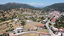
Zarakes (Greek: Ζάρακες, before 1953: Ζάρκα - Zarka[2]) is a village and a community in the Dystos municipal unit of Euboea, Greece. Its population was 632 according to the latest census (2021).[1] The village has historically been Arvanitika speaking.[3]
The community of the same name (Δημοτική Κοινότητα Ζαράκων) comprises Zarakes proper and Paralia Zarakon (Zarakes Beach).
An ancient fortress near Zarakes has been identified with the Eretrian fort Zaretra (Ancient Greek: Ζάρητρα), mentioned by Plutarch.[4]
Attractions in Zarakes include:
- Old village of Zarakes, also known as Μαχαλάς (Mahalas)
- Old mills
- archaeological site of Zarakes near Zoodochos Pigi church
- Old church of Saint Charalampus in old village
Notable people
- Nikos Tranos, sculptor
References
- ^ a b "Αποτελέσματα Απογραφής Πληθυσμού - Κατοικιών 2021, Μόνιμος Πληθυσμός κατά οικισμό" [Results of the 2021 Population - Housing Census, Permanent population by settlement] (in Greek). Hellenic Statistical Authority. 29 March 2024.
- ^ Name changes of settlements in Greece
- ^ Pantelidis, Nikos; Liosis, Nikos (2019). "Dialectical Modern Greek Influences on Arvanitika". Modern Greek Dialects and Linguistics Theory. National and Kapodistrian University of Athens: 224.
- ^ ZARKA (“Zaretra”) Euboia, Greece, entry in The Princeton Encyclopedia of Classical Sites.
External links
- Zarakes historical & folklore website
- Web Camara of Zarakes
- Photo albums from Zarakes & south Evia
- Weather station of Zarakes
- v
- t
- e
Subdivisions of the municipality of Kymi-Aliveri
- Argyro
- Dystos
- Koskina
- Krieza
- Lepoura
- Petries
- Velos
- Zarakes
- Agios Vlasios
- Ano Kourouni
- Kadi
- Kato Kourouni
- Kipoi
- Konistres
- Koili
- Kremastos
- Makrychori
- Manikia
- Monodryo
- Vrysi
- Andronianoi
- Ano Potamia
- Enoria
- Kalimerianoi
- Kymi
- Maletianoi
- Metochi Dirfyon
- Oxylithos
- Platana
- Pyrgos
- Taxiarches
- Vitala
- Agios Ioannis
- Agios Loukas
- Aliveri
- Gavalas
- Partheni
- Prasino
- Tharounia
- Trachili
 | This Central Greece location article is a stub. You can help Wikipedia by expanding it. |
- v
- t
- e


