Ziegler Point
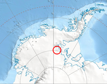
Ziegler Point (79°21′S 83°0′W / 79.350°S 83.000°W / -79.350; -83.000) is a high rock point, or spur, on the southeast side of Gross Hills in the Heritage Range. Mapped by United States Geological Survey (USGS) from surveys and U.S. Navy air photos, 1961–66. Named by Advisory Committee on Antarctic Names (US-ACAN) for equipment operator Ernest L. Ziegler, U.S. Navy, a participant in Operation Deep Freeze 1966 at McMurdo Station.
![]() This article incorporates public domain material from "Ziegler Point". Geographic Names Information System. United States Geological Survey.
This article incorporates public domain material from "Ziegler Point". Geographic Names Information System. United States Geological Survey. ![]()
Portal:
 Geography

- v
- t
- e
Antarctica
- Antarctic sea ice
- Climate
- Climate change
- Heat waves
- Ice shelves
- Geology
- Glaciers
- Mountains
- Tundra
- Volcanoes
| Regions | |
|---|---|
| Bodies of Water | |
| Life |

 Category
 Commons
- Index

 | This Ellsworth Land location article is a stub. You can help Wikipedia by expanding it. |
- v
- t
- e


