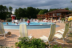
Bad Waltersdorf

Cet article est une ébauche concernant une localité autrichienne.
Vous pouvez partager vos connaissances en l’améliorant (comment ?) selon les recommandations des projets correspondants.
| Bad Waltersdorf | ||||
 Héraldique | ||||
 | ||||
| Administration | ||||
|---|---|---|---|---|
| Pays |  Autriche Autriche | |||
| Land |  Styrie Styrie | |||
| District (Bezirk) | Hartberg-Fürstenfeld | |||
| Code postal | A-8271 | |||
| Immatriculation | HF | |||
| Indicatif | 43+ | |||
| Code Commune | 6 22 64 | |||
| Démographie | ||||
| Population | 3 780 hab. () | |||
| Densité | 72 hab./km2 | |||
| Géographie | ||||
| Coordonnées | 47° 10′ 10″ nord, 16° 00′ 33″ est | |||
| Altitude | 291 m | |||
| Superficie | 5 226 ha = 52,26 km2 | |||
| Localisation | ||||
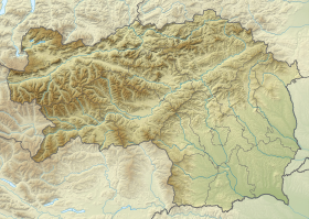
| Géolocalisation sur la carte : Autriche
Géolocalisation sur la carte : Autriche
Géolocalisation sur la carte : Styrie
| ||||
modifier  | ||||


Bad Waltersdorf est une commune autrichienne du district de Hartberg-Fürstenfeld en Styrie.
Géographie
Bad Waltersdorf se trouve à mi-chemin entre la capitale du district, Hartberg, et Fürstenfeld, au milieu du haut-plateau autrichien dans la vallée du Safen, pas loin du Burgenland.
Histoire

Cette section est vide, insuffisamment détaillée ou incomplète. Votre aide est la bienvenue ! Comment faire ?
v · m Communes dans le district de Hartberg-Fürstenfeld | ||
|---|---|---|
|  | |
 Portail de l'Autriche


