Jaba', Haifa
Jaba' Dscheba,[1] Jeba[2] | |
|---|---|
Desa | |
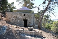 Makam Shaykh Amir, Jaba, pada 2013 | |
| Etimologi: Bukit[3] | |
| 32°39′05″N 34°57′43″E / 32.65139°N 34.96194°E / 32.65139; 34.96194 | |
| Grid Palestina | 146/228 |
| Entitas geopolitik | Mandat Palestina |
| Subdistrik | Haifa |
| Tanggal pengosongan | 24–26 Juli 1948[6] |
| Luas [4] | |
| • Total | 7,012 dunams (7,012 km2 or 2,707 sq mi) |
| Populasi (1945) | |
| • Total | 1.140[4][5] |
| Sebab pengosongan | Serangan militer oleh pasukan Yishuv |
| Wilayah saat ini | Geva Karmel[7][8] |
Jaba' (bahasa Arab: جبع), juga dikenal sebagai Gaba, atau Geba, dalam tulisan-tulisan sejarah, adalah sebuah desa Arab Palestina di Subdistrik Haifa. Desa tersebut dikosongkan dalam Perang Arab-Israel 1948 pada 24 Juli 1948 sebagai bagian dari Operasi Shoter. Desa tersebut berjarak 18.5 km dari selatan Haifa.
Referensi
- ^ Mülinen, 1908, p.283
- ^ Conder and Kitchener, 1882, SWP, II, p. 42
- ^ Palmer, 1881, p. 147
- ^ a b Government of Palestine, Department of Statistics. Village Statistics, April, 1945. Quoted in Hadawi, 1970, p. 48
- ^ Government of Palestine, Department of Statistics, 1945, p. 14
- ^ Morris, 2004, p. xviii, village #168. Also gives cause of depopulation
- ^ Khalidi, 1992, pp. 166, 188
- ^ Morris, 2004, p. xxii, settlement #120
Daftar pustaka
- Barron, J.B., ed. (1923). Palestine: Report and General Abstracts of the Census of 1922. Government of Palestine.
- Benveniśtî, M. (2000). Sacred landscape: the buried history of the Holy Land since 1948 (edisi ke-Illustrated). University of California Press. ISBN 0-520-21154-5.
- Buhl, Frants, (1896): Geographie des alten Palästina. p. 210 ff
- Conder, C.R.; Kitchener, H.H. (1882). The Survey of Western Palestine: Memoirs of the Topography, Orography, Hydrography, and Archaeology. 2. London: Committee of the Palestine Exploration Fund. (p. 251)
- Dauphin, Claudine (1998). La Palestine byzantine, Peuplement et Populations. BAR International Series 726 (dalam bahasa French). III : Catalogue. Oxford: Archeopress. ISBN 0-860549-05-4. Pemeliharaan CS1: Bahasa yang tidak diketahui (link)
- Government of Palestine, Department of Statistics (1945). Village Statistics, April, 1945.
- Hadawi, S. (1970). Village Statistics of 1945: A Classification of Land and Area ownership in Palestine. Palestine Liberation Organization Research Center.
- Hütteroth, Wolf-Dieter; Abdulfattah, Kamal (1977). Historical Geography of Palestine, Transjordan and Southern Syria in the Late 16th Century. Erlanger Geographische Arbeiten, Sonderband 5. Erlangen, Germany: Vorstand der Fränkischen Geographischen Gesellschaft. ISBN 3-920405-41-2.
- Khalidi, W. (1992). All That Remains: The Palestinian Villages Occupied and Depopulated by Israel in 1948. Washington D.C.: Institute for Palestine Studies. ISBN 0-88728-224-5.
- Mills, E., ed. (1932). Census of Palestine 1931. Population of Villages, Towns and Administrative Areas. Jerusalem: Government of Palestine.
- Morris, B. (2004). The Birth of the Palestinian Refugee Problem Revisited. Cambridge University Press. ISBN 978-0-521-00967-6. (pp. 96, 177, 245, 247, 299, 438-41, 457, 458)
- Mülinen, Egbert Friedrich von 1908, Beiträge zur Kenntnis des Karmels "Separateabdruck aus der Zeitschrift des Deutschen Palëstina-Vereins Band XXX (1907) Seite 117-207 und Band XXXI (1908) Seite 1-258."
- Palmer, E.H. (1881). The Survey of Western Palestine: Arabic and English Name Lists Collected During the Survey by Lieutenants Conder and Kitchener, R. E. Transliterated and Explained by E.H. Palmer. Committee of the Palestine Exploration Fund.
- Schürer, E. (1891). Geschichte des jüdischen Volkes im Zeitalter Jesu Christi [A History of the Jewish People in the Time of Jesus Christ] (dalam bahasa English). 1. Diterjemahkan oleh Miss Taylor. New York: Charles Scribner's Sons. Pemeliharaan CS1: Bahasa yang tidak diketahui (link)
Pranala luar
- Welcome To Jaba'
- Jaba', Zochrot
- Survey of Western Palestine, Map 8: IAA, Wikimedia commons
- Jaba' at Khalil Sakakini Cultural Center


