Rozenburg

Bendera

Lambang kebesaran

(2006)
(1 January, 2007)
Rozenburg [ˈroː.zə(m).ˌbʏr(ə)χ] ⓘ adalah sebuah bekas gemeente Belanda yang terletak di provinsi Holland Selatan. Pada tahun 2003 daerah ini memiliki penduduk sebesar 13.240 jiwa.

-
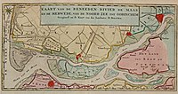 Rozenburg Island in 1769
 -
 Rozenburg Island in 1867, just before the construction of the Nieuwe Waterweg, its planned route visible in the top left corner
 -
 Satellite image of the Rhine-Meuse delta showing the island of Rozenburg (10)


Referensi
- l
- b
- s


